L.A. Drives: Topanga and Malibu canyons

Join Charles Fleming on an L.A. Drive through Topanga Canyon, Mulholland Highway, Malibu Canyon and Pacific Coast Highway.
Los Angeles roads and freeways may feel like a frenzy, but just outside the city lies a honeycomb of world-class motoring opportunities.
Welcome to L.A. Drives, a new feature whose mission is to take a hot car, add a cool route, throw in a little history and sightseeing, and create an adventure.
On this outing, we took a bright blue Aston Martin V12 Vantage S convertible. The first order of business? Take down the top and crank up the tunes.
We started south on Pacific Coast Highway and headed into the hills up Topanga Canyon Boulevard. The flat winding road soon gained altitude and turned twisty before scooting through the funky community of Topanga Village.
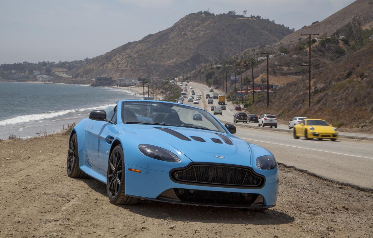
A bright blue Aston Martin V12 Vantage S convertible is the car of choice for Charles Fleming on his L.A. Drive through Topanga Canyon, the Santa Monica Mountains and Malibu.
This was once a great artists’ enclave, and during the ‘60s was ground zero for a lot of cutting-edge rock ‘n’ roll. Today, it’s still funky — home to feed stores that supply the horsey folks living in these hills and a few incense-burning shops, yoga studios and restaurants.
We grabbed a quick espresso at the Water Lily Cafe, and left Topanga Canyon Boulevard for Old Topanga Canyon Road, gliding past Inn of the Seventh Ray, a romantic canyon eatery that has been serving eclectic meals for more than 40 years.
Old Topanga is a shady drive, overhung with sycamore and oak trees, that rolls past some houses that, judging from the smell, make good use of those feed stores we passed earlier. It turned even curvier as we approached the summit and scooted down the other side.
Having left the ocean side of the mountains for the valley side, we turned left onto Mulholland Highway. Here the pace picked up, and we were able to unspool the big V-12 convertible a little as we drove along this storied road.
Though not all of it is paved — or open to the public, or appropriate for a low-slung English sports car — Mulholland stretches all the way from Griffith Park in the east to Leo Carrillo State Park, and the Ventura County line, to the west.
We were careful not to push the Aston Martin too hard. The speed limit along this stretch of Mulholland is 45 mph, and the CHP guards it assiduously — especially on the weekends. A friend of mine was told, by the officer who ticketed him, “This is my road.”
For a little dip into local history, we turned left into King Gillette Ranch just before Mulholland meets Malibu Canyon and Las Virgenes Road.
This bucolic oasis, now part of the Santa Monica Mountains National Recreation Area, was home to entrepreneur King Gillette, who made his fortune perfecting the disposable razor blade. He built this ranch in the 1920s and lived here for a while.
The property was later owned by a film director who built a private airfield so he could fly in his Hollywood friends for parties, then by Bob Hope, the Catholic Church, evangelist Elizabeth Clare Prophet and Soka University before it was made a public park in 2007. It still has some Hollywood in it, though. The TV show “The Biggest Loser” is filmed in a compound at the back of the park, where parking and admission are free.
There’s also a lot of other Hollywood lore nearby at Malibu Creek State Park, where scenes from the TV show “M*A*S*H*” and the movie “Planet of the Apes” were shot.
We returned to Mulholland after visiting the ranch, and then turned left again onto Las Virgenes Road. Then, for another dose of history and religion, we turned left at the next corner to visit Malibu Temple, a Hindu house of worship.
Begun in 1981 and managed by the Hindu Temple Society of Southern California, this is an active house of worship. Visitors are asked to take off their shoes and comport themselves respectfully. Also, a sign says, no offerings of coconut or burning of camphor are allowed. So we took our shoes off, behaved ourselves and offered no coconuts.
Back on Las Virgenes Road, we continued west, following Malibu Canyon as it wound past Tapia Park and Camp David Gonzales, a juvenile education facility run by the Los Angeles County Probation Department.
It’s a sweeping, breezy drive back to the coast. We relaxed and let the Aston Martin cruise down 7.4 miles of gorgeous canyon, past the great lawns of Pepperdine University and back onto Pacific Coast Highway.
Did the car improve the drive? Maybe, but just a little. This is a great drive no matter what you’re driving.
Heading left, or south, Pacific Coast Highway coasts through the town of Malibu, passing Malibu Lagoon State Park on the right and Malibu Country Mart on the left, which offers a variety of shopping, dining and caffeination options. Just beyond is the Malibu Pier, which is a great spot for watching the local surf scene or grabbing some lunch or a cold beverage.
We drove on, another 12 miles south, down PCH to our starting point at Topanga Canyon. Here, there are more choices. We could’ve finished the adventure with a fresh fish meal at the Reel Inn or a cold drink from Wylie’s Bait and Tackle — both places have been there for decades — or a full dinner farther south at Mastro’s Ocean Club, at the site of the old Charthouse restaurant.
When we were done, we had clocked 32 miles of classic Southern California canyons and coastline. That’s a great L.A. Drive.
L.A. Drives is a regular feature designed to make the most of Southern California’s great motoring opportunities. Stay tuned for more dramatic drives.
Twitter: @misterfleming
