Highway 1 was buried under a massive landslide. Months later, engineers battle Mother Nature to fix it

On unstable ground: Engineers and road workers fight Mother Nature while trying to fix Highway 1 at Mud Creek in Big Sur.(Video by Brian van der Brug / Los Angeles Times)
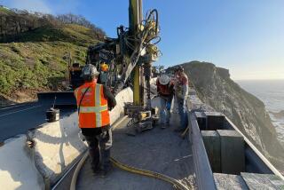
On a sunbaked, dust-scoured road overlooking the Big Sur coast, four men in hard hats and fluorescent vests huddle against the stiffening wind. Worry isn’t in their nature, but that doesn’t mean they aren’t concerned.
This Wednesday morning, with the summer nearly over, portents of fall — like the wind — bring uncertainty, and uncertainty can mean trouble when you’re standing on top of the largest landslide to bury Highway 1.
“Come the middle of November, we’re going to start seeing big surf coming in from Hawaii, and it’s going to just clobber the toe.”
John Duffy is speaking. He is an engineering geologist, 63 years old, and often cited as an expert in landslide management. He is also an avid surfer.
Duffy is concerned about erosion. Loss of the toe — the 15 acres of land that the slide pushed out to sea — would compromise what they’ve accomplished in the last four months.
“We’ve already lost 100 feet of shoreline,” says Lance Gorman, a major damage restoration engineer.
The men look down at the excavators and dozers maneuvering massive chunks of granite on the south flank of the toe into what looks like a breakwater just above the wrack line. A similar barrier was recently completed on the north flank.
If you lived 1,000 years, you’d probably never see anything like this.
— Augie Wilhite, John Madonna Construction
Ever since May, when a near-vertical slope of mountain collapsed at a place called Mud Creek, teams of geologists and engineers have clawed over rocks and boulders, through brush and chaparral, to come up with a plan for reconnecting this severed artery.
The rebuilt highway, they decided, would lie on top of the slide, and the California Department of Transportation, manager of the $40-million project, hopes to see traffic flowing by the end of next summer.
Up the coast, the Pfeiffer Canyon Bridge — brought down by a landslide in February — has reopened, a Herculean demolition and construction project completed in just eight months, but Mud Creek, says Duffy, is more complicated.
Estimated to be 5 million cubic yards, the rock and mud sloughed off this mountain would by one estimate fill the Rose Bowl seven times, and while the worst seems over, Mud Creek could surprise them.
“The earth,” says Duffy, “is still adjusting and trying to find a state of equilibrium.”
Driven by the urgency to open the highway — visitors hoping to drive the coast, businesses and residents dependent on access — Duffy and his colleagues are practicing engineering on the fly, trying to move ahead with a long-term plan while adapting to sudden exigencies such as erosion and imminent rockfalls.
Gorman pulls out a piece of slightly crumpled graph paper detailing his solution: to connect the two breakwaters, creating a solid line of rock across the width of the slide.
They pause. His plan — an additional 1,410 feet of boulders stretching nearly four football fields — means more material, more money, more time. The scale of the slide never fails to impress them.
“If you lived 1,000 years,” says Augie Wilhite with John Madonna Construction, “you’d probably never see anything like this.”
::
California has seen larger landslides.
Jump back in time, say 18,000 years ago, and you will come upon the Blackhawk landslide that poured down the north slopes of the San Bernardino Mountains near the Lucerne Valley at speeds of up to 300 mph, carrying with it 300 million cubic yards of material.
More recently, there have been huge slides on Santa Cruz Island, on the Palos Verdes Peninsula and, of course, in Big Sur, whose geology — like most of the West Coast — is a fractured mess of stone lying in the Franciscan Complex, an unstable mélange of shale and schist, serpentine and basalt created over millions of years of subduction, upthrust and faulting.
In 2001, the California Geological Survey studied 73 miles of the coastal route and counted 1,404 landslides, both dormant and active. If there are no cost overruns on Mud Creek, California will have spent close to $105 million since 2009 keeping a few of these slides at bay.
Geologists such as Duffy, who has worked on the coast for more than 30 years, first with Caltrans and now with a private engineering firm, Yeh and Associates, know this topography by heart: Elephant’s Trunk, Salmon Creek, Gray Slip, Shale Point and the most well-known, a stretch of coast just north of Julia Pfeiffer Burns State Park.
A landslide there displaced nearly 2 million cubic yards of material and closed Highway 1 in 1983. For more than a year, 30 dozers and 7,700 pounds of explosives removed nearly 3 million cubic yards of rock and soil, most of which landed in the ocean.
“The old J.P. Burns landslide represented an old approach to landslides,” says Duffy, “in which we brought in heavy equipment and changed the landscape entirely.”
The strategy was criticized for being too intrusive, and Caltrans, said Duffy, is still defensive about that work. Thirty-five years later, the agency not only has better equipment but, as Duffy claims, a better understanding of slope management, applying strategies that don’t prescribe the wholesale removal of failed material.
What is most significant, in Duffy’s mind, are not the landslides — “we will always have landslides,” he is fond of repeating— but the increased use of the highway over the last 20 years.
“Highway 1 used to be a three-season road,” he says, like the roads over the Sierra. “Now it’s open all year long.”
Increased use makes a discussion of economics unavoidable. According to one study, the route carries about 3,000 vehicles a day to the resorts, art galleries, hotels and restaurants of Big Sur and to the residences scattered along the highway.
“Even if only half are tourists,” he says, “spending money on a motel, a dinner, a sweatshirt or ceramic sea otter, then that really adds up.”
::
Like the surface of some distant planet, Mars perhaps, the Mud Creek construction site is as forbidding as it is beautiful.
Cold gusts turn the ocean into a carpet of whitecaps, and by midafternoon, crew members will be fighting 30 mph gusts blasting off the Pacific. They tie bandannas around their necks, pull hoodies over their heads and under their hard hats. Gloves and jacket sleeves poke out of tangerine vests.
Putting in 12- to 14-hour days, seven days a week, they have scrambled up Mud Creek’s slopes with ropes and slalomed down in a cascade of scree. Pebbles in their shoes, they have courted the contours of the slide as if getting to know a lover, which may seem an excess of poetic license until they start referring, as they do, to its body, flanks, toe and crown.
If they’re wary of the media, steadily drawn to this disaster on California’s iconic coast, it’s because they dislike being second-guessed, and with more than 70 stakeholders ranging from the California Coastal Commission to local wildflower groups, that’s an ongoing reality.
Besides, they have a job to do.
Caltrans has never been completely comfortable with this stretch of Highway 1, eyeing it as an adult might an errant teen. For the most part, it behaved.
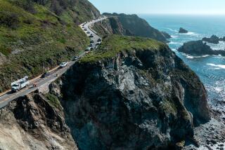
Mud Creek had been a seasonal drop of water from the Silver Peak Wilderness, not even warranting mention on maps. Here cliffs had forced the highway to hug the edge, the surf a long fall just beyond the shoulder.
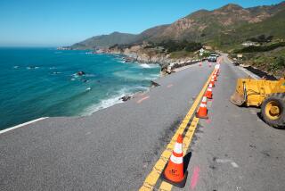
Last winter, Mud Creek came of age. With smaller, adjacent springs, it spilled over and under the road, which by February had dropped 4 feet. By March, construction crews had established a permanent post here with dozers and backhoes, each day a Groundhog Day as they tried to stabilize the shifting asphalt and keep a lane open.
By May, the mountain began a more serious assault.
After a routine flyover, Jonathan Warrick with the U.S. Geological Survey recalls reviewing images of the slide and seeing the road, broken into 3-foot chunks of asphalt, taking a hard right into the ocean. Warrick and other researchers study the Big Sur coast to understand the behavior of landslides and prevent disasters like La Conchita, Calif., in 2005 or Oso, Wash., in 2014.
“The Big Sur coast with its spectrum of rock types and varied topography makes a great natural landslide laboratory,” says his colleague Kevin Schmidt. “The more we can learn from environments like these, the better our understanding of how, where and when future large slides may occur.”
One day, Warrick saw something ominous. A fissure had begun to open in a slope nearly 1,000 feet above the ocean where there was a small grove of oak trees.
“At first there were four of them, and then only three,” Warrick said. “One had slipped downslope 100 feet.”
On May 17, construction crews evacuated, and three days later, during the night of May 20, the mountain collapsed, spewing 5 million cubic yards of rock and mud downslope and nearly 650 feet into the ocean.
Everyone still counts their good fortune not being here.
::
Five months later, Mud Creek is a closely watched parcel of California real estate. Microwave units, like traffic cops’ radar guns, survey the mountain every three minutes, and lasers shoot light on tetrahedral prisms mounted on 19 boulders, registering the smallest shift.
Geologists and on-site personnel study PET-scan-like images of the slide, colored green to yellow to red, low risk to high risk. If something moves, the call goes out.
“No one gets too far from a radio out here,” says Radar Dave — David Cummings — who’s responsible for signing in visitors, conducting safety checks and keeping an eye on the mountain.
He greets Duffy and Wilhite as they climb aboard a fat-tire golf cart to rock and roll over the roads on the slide. No one fastens a seat belt, just in case they have to jump.
Offshore, a line of pelicans skirts the muddy turquoise water, and to the south, sunlight, cutting through wisps of fog, checkerboards the ocean and headlands toward the Piedras Blancas Light Station.
Wilhite wheels around the end-dump trucks, filled with boulders from a Cambria quarry, and a water truck, trying to keep the dust down.
Within days of the mountain’s failure, the reconnaissance began.
Geologists mapped not only material that slid into the sea, but also the vertical slope where that material once resided, and engineers plotted the new road.
Because there wasn’t room to go around the slide, and because a tunnel would be too long, requiring nearly two miles in order to find stable ground for its entrances and exits, the best option was to go over the slide. As they sketched the plan, they secured the site.
After carving a network of roads and terraces on top of the slide, they dug a catch basin at the base of the vertical slope, where boulders — calving from above — could land without bounding into the crews below. Sixteen shipping containers, each holding three K-rails, were brought in as an additional defense.
To fight ocean erosion, they began building the twin breakwaters, technically known as revetments, on the slide’s northern and southern flanks, and behind each revetment they plan to build up layers of soil and fabric to keep pressure on the hillside just below the path of the road.
For now, the road is a sinuous line on paper: two 12-foot lanes and two 4-foot shoulders with three gradual turns, tuned to 45 mph. There is talk of adding a turnout with signage explaining the nature of the slide.
::
The golf cart bounces onto the beach at the base of the northern revetment, and Duffy likes what he sees. Maybe the extension of the breakwater running across the toe, as they discussed this morning, will not be necessary.
Waves are breaking offshore. Curling left, they meet a gradual slope of sand, rushing — not slamming — against the toe, their energy diminished.
“We’re seeing the development of a break,” he says, which might save the toe.
Duffy associates the work on Highway 1 to other great feats of American engineering, projects not unlike the laying of steel for the transcontinental railroad or pouring concrete for the interstate highways, accomplishments that have required steady maintenance over the years.
Highway 1 is no different, for as Duffy is certain, the mountains of Big Sur will never stop moving.
Four weeks later — after more evaluation and studies — the engineers and geologists at Mud Creek decided to extend the northern and southern revetments across the toe. The longer barrier will give the highway additional security.
The winter swell, waves up to 20 feet, had arrived.
Twitter: @tcurwen
More to Read
Start your day right
Sign up for Essential California for news, features and recommendations from the L.A. Times and beyond in your inbox six days a week.
You may occasionally receive promotional content from the Los Angeles Times.
