California storm: Hail, waterspouts, ‘weak’ tornadoes forecast
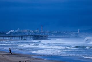
The latest round of the most powerful winter storm to hit Southern California in two years will bring periods of heavy rain, thunderstorms, some hail, damaging winds and even the possibility of waterspouts and weak tornadoes on Saturday, according to the National Weather Service.
Coastal and valley areas could get up to 1½ inches of rain, while mountain areas could see double that. The snow level is hovering at about 6,000 feet.
Early Saturday morning, the weather service issued a tornado warning for parts of L.A. County. The weather service posted on Twitter a map showing what it said was “a weak tornado” near Walnut and Azusa. No injuries were reported.
PHOTOS: Rain storm hits the Southland
In an advisory issued Saturday morning, the weather service said areas about 7,000 feet could see up to two foot of snow, while coastal areas can expect high surf.
Evacuations remain in effect in foothill communities in the eastern San Gabriel Valley, which saw mudflows Friday and where some hillsides are unstable.
A strong low-pressure storm system poised off the coast will move inland over the weekend, bringing up to 3 inches of rain to the coast and up to 10 inches in some mountain areas. Winds will be powerful; some inland portions of San Bernardino, Riverside and San Diego counties could see gusts of 65 mph or more.
Evacuations remain in effect in the foothill communities of Glendora and Azusa, east of Pasadena and in the shadows of the Angeles National Forest. There, an illegal campfire erupted into the 2,000-acre Colby fire in January, destroying five homes and leaving thousands of others exposed to danger beneath denuded slopes.
Authorities, fearing that homes could be inundated with mud and debris, issued evacuation orders for about 1,000 homes in Glendora and an additional 200 homes in nearby Monrovia. But in some areas residents estimated that as many as three-quarters of homeowners had ignored the “mandatory” evacuation and elected to stay put, a decision that did not please fire and rescue officials.
“Understand this: If there is mud coming down, fire personnel cannot get to you,” warned Steve Martin of the Los Angeles County Fire Department. “There’s a reason for these evacuations.”
An unstable hillside in Azusa prompted police to order evacuations Friday evening of all 26 homes on Ridge View Drive in the Colby fire burn area.
“The hillside is not stable,” said Azusa police Sgt. Sam Fleming, adding there was already 2 to 3 feet of mud in the backyards of two homes on the street.
“Mud is extremely heavy, and people can get stuck real quick,” Fleming said. “Should that hillside go, it’s going to happen quickly. We’re wanting to get as many people [as possible] out quickly ... because there won’t be a lot of time.”
L.A. saw its driest year on record in 2013. This storm was been the most significant rain in two years. Downtown L.A. received more than two inches or rain Friday, more than the entire rain season, which started in June, so far.
More to Read
Start your day right
Sign up for Essential California for news, features and recommendations from the L.A. Times and beyond in your inbox six days a week.
You may occasionally receive promotional content from the Los Angeles Times.
