Earthquake that rattled L.A. was most powerful in years

The magnitude 5.3 earthquake that rattled Southern California on Thursday was the strongest in the region in several years.
The magnitude-5.3 earthquake that rattled Southern California on Thursday was the strongest in the area in several years.
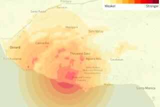
Though there were no immediate reports of damage, the quake was felt across a wide area and was a blunt reminder that California is earthquake country. The U.S. Geological Survey put the epicenter about 23 miles off the Channel Islands, about 85 miles west of Los Angeles.
Earthquake early-warning system gave heads-up before 5.3 magnitude temblor hit L.A. area>>
It was centered near the Eastern Santa Cruz Basin Fault Zone, Caltech seismologist Egill Hauksson said. “Earthquakes happen out there now and again. There’s a major offshore fault system,” he said.
Seismologist Lucy Jones said on Twitter that the fault system “moves Southern California around a bend of the San Andreas fault.”
There is a slightly greater likelihood that the the temblor could trigger a larger earthquake, but that chance decreases with time, Hauksson said.
The last big earthquake in the Channel Islands region before Thursday’s temblor was in 1981, which was a magnitude 6.0, Hauksson said. A magnitude 4.8 quake struck near the islands in 2013.
One of the last quakes to be felt this widely in the L.A. area was a magnitude 4.4 in Encino in 2014. That quake also shook a wide area and was the largest in the Los Angeles area in four years. It was the strongest to hit directly under the Santa Monica Mountains in the 80 years.
Another widely felt earthquake came later that same month, a magnitude 5.1 centered in La Habra. Residents close to the epicenter reported toppled furniture, broken glass and fallen pictures; several water mains broke, and a rock slide caused a car to overturn, and more than a dozen homes and apartments were declared uninhabitable because of possible structural damage.
The Santa Barbara area is home to a number of earthquake faults, the largest of which is the Santa Ynez fault, which is 80 miles long and runs just north of the city. That fault is believed to be capable of triggering an earthquake as powerful as 7.5.
The great Santa Barbara quake of 1925, recorded as a magnitude 6.8, destroyed a significant portion of the city’s downtown area, damaged rail lines and caused extensive landslides on bluffs. It killed 13 people and was felt as far away as Orange County.
Since the magnitude 7.2 Easter Sunday earthquake of 2010 that hit along the California-Mexico border, there have been 14 earthquakes of magnitude 5 or greater in Southern California. Hauksson estimated that perhaps about half of them were felt in Los Angeles.
Get ready for a major quake. What to do before — and during — a big one>>
UPDATES:
12:35 p.m., April 6, 2018: This article was updated with a reference to another recent earthquake that was felt widely throughout L.A., the 2014 La Habra earthquake.
1:50 p.m.: This article was updated throughout with additional details and background.
1:25 p.m.: This article was updated with information on the magnitude 6.0 quake that struck the Channel Islands in 1981.
This article was originally posted at 12:55 p.m. on April 5, 2018.
More to Read
Start your day right
Sign up for Essential California for news, features and recommendations from the L.A. Times and beyond in your inbox six days a week.
You may occasionally receive promotional content from the Los Angeles Times.
