Go with the floe to ‘Iceberg Alley’
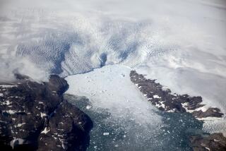
The icebergs that travel to Labrador are time capsules -- sealed thousands of years ago, when snow fell on Greenland. The snow compressed into glacial ice, white from the trapped air bubbles, these from pre-pollution times.
Today, that glacial ice oozes and creeps toward the waterline. Its edges melt and break off, catching the frigid Labrador Current. Every year, an opalescent armada drifts south toward Canada.
And every year, more and more travelers like my companion and me make a pilgrimage to the austere and sparsely populated coasts of southern Labrador and northern Newfoundland to greet those bergs.
Streaked and shimmering, arched and tunneled, spired and prowed, pummeled and listing, these frozen behemoths briefly mesmerize, then melt. For centuries, fishermen cast their nets here for cod until the species became depleted and the waters were closed to fishing in 1992.
Its impressive bergs earned this stretch of the Atlantic a moniker: Iceberg Alley. The fishermen whose nets were once ripped by itinerant floes now haul tourists for close-up views of their former nemeses.
During high season, from late May to late June, more than 1,000 icebergs stream down the alley. In good years -- 2007 saw a bumper crop -- they decorate the bays and jam the harbors. But there’s no predicting how many will turn up near land. The number depends on the prevailing winds, recent weather and sea ice cover.
For iceberg aficionados, they’re worth the wait. Although the technical terms for iceberg forms are prosaic -- tabular, blocky, wedged, domed, pinnacled and dry docked (U-shaped) -- in real life, these glacial carvings are pure poetry: “stupendous ramparts,” wrote Edgar Allan Poe, “. . . towering away into the desolate sky, and looking like the walls of the universe.”
THE LABRADOR COAST
Our iceberg quest last year started on the car ferry from St. Barbe, Newfoundland, across the Strait of Belle Isle to Blanc-Sablon, the easternmost community in Quebec. Without icebergs, the trip takes 90 minutes. During high season, it may take up to nine hours -- for the very reason one travels all this way: Icebergs of every size and shape clot the strait while harbor seals drape themselves on pack ice.
Icebergs aren’t the only draw. East along Route 510, the Labrador Coastal Drive, a gorgeously spare landscape unfolds. The winding road from L’Anse-au-Clair to Red Bay takes you past dwarf conifers and salmon-rich rivers, aboriginal burial mounds and hulking boulders. This pristine glacial field saw the retreat of the continental ice sheet a mere 10,000 to 15,000 years ago.
The only vertical element against an endless sky is a rhythmic line of bleached phone poles. Dotting the highway are fishing outposts and visitor centers, where you can inquire about iceberg prospects at the next cove or bay down the road.
In this otherwise overlooked corner of Canada, you won’t find plush accommodations or provocative cuisine. The typical B&B experience is a spare room in someone’s basement. Local fare features traditional fish and brewis: boiled and mashed salt cod on hard tack or hard bread soaked overnight, topped with scrunchions -- crisp fried bits of salt pork.
Save your appetite for dessert: homemade pie made from the delicate and tart local squashberries, partridgeberries or cloudberries.
At the end of the 50-mile paved road is Red Bay, once a flourishing Basque whaling site that supplied oil to Europe for lamps and soap. Now, Red Bay has calved its young people to Quebec and to the petroleum oil fields up north; the place feels slightly forlorn. But last year, the town’s iceberg viewing season was one of the best in memory, with 40 to 50 frozen specimens congregating in the bay and harbor.
A trek up the town’s boardwalk to the World War II hilltop lookout known as American Rocky Man offers a panoramic view. A coin-operated telescope brings the action up close -- so close that what appears to be a gleaming crystal sculpture from afar can look stained and raggedy under magnification. Even for “stupendous ramparts,” thousands of years and 1,800 nautical miles take a toll.
The fantastical shapes of icebergs result from the deteriorating forces of waves, wind and melting. They range from flat, stadium-sized slabs to growlers (named for the sound they make spinning in the water) about the width of a grand piano.
Iceberg allure also stems from illusion. From land, it’s nearly impossible to gauge the size and location of a berg without a reference point, such as a bird, boat or trees on an adjacent shoreline. And although the massive proportions make icebergs appear solid, they are in constant flux.
Most of their bulk is below water (seven-eighths, to be exact), and close approach by boat is dangerous. But kayakers can’t seem to resist paddling in close to touch their surface. For them, the risk is not so much that the berg will roll -- a kayak would float on the sudden swell -- but that sheets of ice may vertically sheer off.
‘FROZEN HURRICANES’
Then too, icebergs can explode under the thermal pressures of sunlight. A cathedral-like formation may suddenly plunge in the ocean or shatter into a thousand pieces. The sound resembles a grenade going off.
It’s no wonder that seasoned iceberg watchers carry motor-driven cameras. Or that the operators of offshore oil rigs spend millions each year towing bergs away from their operations. As one Atlantic oilman described it, icebergs’ destructive power puts them in the category of “frozen hurricanes.”
But iceberg viewing needn’t be a contact sport. For some, the appeal of iceberg tourism is that in a provincial capital such as St. John’s, Newfoundland, you can sunbathe and sip on sangria while taking in these strange passersby from the Arctic.
For the ultimate iceberg show, however, detour to Quirpon Island, a rolling, moss-and-juniper-clad speck off the extreme northeastern tip of Newfoundland’s Great Northern Peninsula, about 45 minutes by boat from the mainland.
Quirpon (pronounced CAR-poon) was once home to an 1860s lighthouse that guided sailing vessels and steamships. The lighthouse is now automated and the lightkeeper’s 1922 home has been transformed into a comfortable inn, with simple but hearty meals, convivial conversation -- and no telephones or TV in the rooms.
Linkum Tours, which owns the isle, advertises “the longest iceberg viewing season in Newfoundland.” From the wide wooden helipad overlooking the mouth of Belle Isle Strait, we could gaze in every direction at a tableau not only of icebergs but also humpback, minke and orca whales. (The same current that carries icebergs here is a watery conveyor belt for fish between the Gulf of St. Lawrence and the Atlantic.) At sunset, their breaching and spouting and chuffing were surreal, like an outdoor Imax movie.
Early in the morning, we scrambled down the rocks to see what the current had brought in. Faceted bergs and whale flukes lighted up in the rising sun. When we grew tired of squinting at the distance, we tramped around the island, every step lofted by springy ground cover that invites napping. The only sounds were those of the surf, whales and seabirds.
At sunset on Quirpon, a bottle of Grand Marnier appeared. The dinner table was set with clear glass pitchers of water: iceberg water, chilled by iceberg ice harvested in 5-gallon buckets from the cove.
When immersed in whichever beverage you prefer, the ice makes a popping sound that has earned it the label bergy seltzer: tiny explosions of compressed air bubbles trapped in the original snow layers millenniums ago. Chemically, the liquid is indistinguishable from distilled water. But in this remote and wild setting, the clean, soft taste was beyond compare.
On Quirpon, sipping iceberg water (or triple sec with iceberg cubes) while gazing out at icebergs was a highly agreeable form of suspension. Nature came full circle. The time capsule had opened.
More to Read
Sign up for The Wild
We’ll help you find the best places to hike, bike and run, as well as the perfect silent spots for meditation and yoga.
You may occasionally receive promotional content from the Los Angeles Times.


