El Nino watch issued; could portend rain for dry California
The odds are increasing that El Niño, the powerful climate phenomenon that alters precipitation patterns across the globe, will develop in the Pacific Ocean this year, U.S. government forecasters say.
The National Oceanic and Atmospheric Administration’s Climate Prediction Center activated its alert system on Thursday to issue an El Niño watch.
The alert means that conditions in the eastern tropical Pacific are favorable enough that El Niño has a more than a 50% chance of forming by the summer or fall.
Though it’s too early to predict with much confidence, if El Niño re-emerges it could produce wetter weather in the southern United States next winter, bring more rain to California, temper the Atlantic hurricane season and push up global temperatures in 2015, experts say.
The El Niño cycle begins every two to seven years when weak trade winds in the Pacific allow warmer water to build up along the west coast of South America.
El Niño conditions often result in higher rainfall in California, but not always. Typically, they cause the jet stream to dip south over North America, directing storms to the California coast and across the southern U.S. La Niña, the cycle’s cool-water counterpart, is associated with drier weather in those regions.
If El Niño returns this year it would be the first since 2009-10, a moderate episode that was followed by the next season by La Niña. For the past two years the eastern tropical Pacific has remained in neither a cool nor warm state some experts have referred to as “La Nada.”
Thursday’s forecast by the Center for Climate Prediction and International Research Institute for Climate and Society at Columbia University, gave a 52% probability of El Niño developing by the fall, compared with a 41% chance of conditions remaining neutral.
Mike Halpert, acting director of the Climate Prediction Center, said scientists have observed a warming of sub-surface waters that has been “fairly impressive.”
“We’re seeing a fair amount of evolution towards El Niño below the surface and we’re getting some confirmation from a number of our computer models,” he said. “It looks pretty good at this point.”
Thursday’s El Niño watch follows several months of forecasts based on observations from satellites, buoys and floats and computer models that have shown increasing signs El Niño could return later this year.
Halpert cautioned that El Niño forecasts before spring are notoriously unreliable because of volatile ocean and atmospheric conditions. Predictions made this early in past years, he said, have sometimes failed to play out.
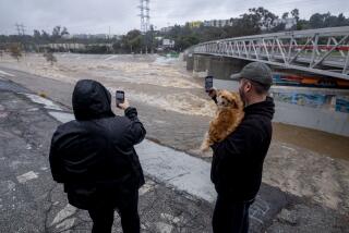
The last major El Niño, an unusually powerful episode in 1997-98, brought rainfall more than 200% above normal to Southern California. Powerful storms hit the coast, triggering destructive landslides and floods.
With California still in a drought, the state might be more open to the risks posed by El Niño if it meant an influx of needed rain, Halpert said.
“For the folks in California, this might be a case where they would welcome that,” he said. “You might take a bit of the bad to refill your reservoirs.”
Twitter: @tonybarboza


