Florida on edge as Hurricane Dorian becomes a major Category 3 storm
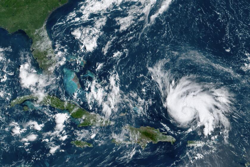
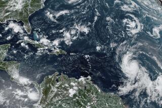
Hurricane Dorian continued to gain strength Friday, becoming a major Category 3 storm with 115 mph winds as it moved over the Atlantic Ocean and threatened to strike Florida’s east coast with a force it hasn’t experienced in decades.
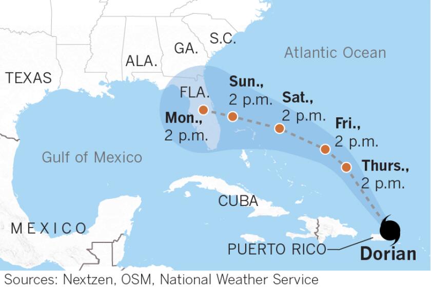
The National Hurricane Center expects Dorian to make landfall early Tuesday as a potentially catastrophic Category 4 storm. The center’s projected track shows the storm slamming into West Palm Beach in central Florida, but meteorologists warned its track could change over the next few days.
For now, Florida’s entire eastern coastline, including Miami and Jacksonville, remain in Dorian’s “cone of uncertainty” and face the prospect of strong wind, heavy rain and a life-threatening storm surge.
“I don’t think anybody in the state of Florida, from the Georgia state line down to the Keys, can say that they’re out of the woods,” said W. Craig Fugate, an emergency response consultant and former administrator of the Federal Emergency Management Agency. “Nor can they say they’re going to get hit. So it’s like, get ready!”
Brian McNoldy, a hurricane researcher at the University of Miami, said Dorian would almost certainly intensify over the next few days.
“It’s got a very warm ocean the whole way and very low wind shear and not a lot of dry air to contend with, which is what kept the storm from intensifying when it was in the Caribbean,” he said.
If Dorian does build in strength, it could be the first Category 4 or higher hurricane to make landfall on Florida’s Atlantic coast since 1992, when Andrew struck south of Miami as a Category 5.
That storm killed 65 people and left more than $25 billion in damage.
President Trump, who called Dorian an “absolute monster,” formally declared an emergency in Florida on Friday, authorizing the Department of Homeland Security and the Federal Emergency Management Agency to coordinate disaster relief efforts alongside state and local officials.
“All indications are it’s going to hit very hard, and it’s going to be very big,” Trump said from the Rose Garden outside the White House, in a video posted Thursday night on Twitter. “It may be that you’re going to evacuate. We’ll see what happens. We’re waiting.”
Two years ago, then-Florida Gov. Rick Scott ordered more than a million people to evacuate days before Hurricane Irma hit the state.
Gov. Ron DeSantis has declared a state of emergency in all 67 counties and activated 2,500 members of the Florida National Guard, with an additional 1,500 on standby.
Speaking at a media briefing Friday at the Emergency Operations Center in West Palm Beach, DeSantis said that state officials were monitoring options for evacuation, and that for “certain people” it was going to be necessary.
If evacuation orders are issued, he said, the state will suspend all road tolls and open the shoulders of major highways, such as I-95 and I-75, for heavy traffic.
In the meantime, DeSantis urged Floridians to heed local officials and prepare by stockpiling a seven-day supply of water, medicine and nonperishable food.
“If it hits here, there will be power outages and it’s not going to be put back on right away,” he said. “So take time to prepare. … The one constant is that this storm is getting stronger.”
Early Friday, Dorian’s winds increased from nearly 105 mph to 110 mph in just a few hours. By late afternoon, the storm was a Category 3 hurricane, moving west-northwest about 595 miles east of West Palm Beach with maximum sustained winds of 115 miles per hour.
Tropical storm and hurricane conditions may be felt on the Florida peninsula as early as Sunday, but the storm is likely to slow down in the coming days.
“That gives it more time over the warm ocean to intensify,” said McNoldy. “But it also gives people more time to prepare or evacuate.”
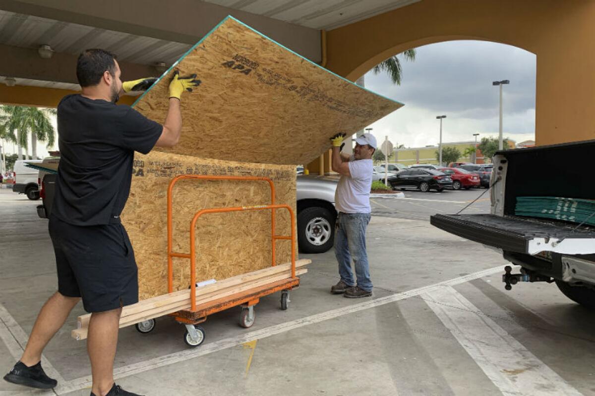
Across Florida, residents began to stockpile supplies, emptying stores of bottled water and canned goods. Lines of motorists waiting for gas became so long that Florida’s Highway Patrol moved to escort fuel trucks to gas stations to replenish pumps.
On what is usually one of the busiest travel weekends of the year, major airlines waived fees for passengers wishing to change reservations to Florida and the Bahamas. Cruise companies changed their Caribbean itineraries and rerouted ships from Florida. Workers at NASA’s Kennedy Space Center in Cape Canaveral used a massive transporter to move its 400-foot Launch Pad 39B to its vehicle assembly building in an attempt to keep it from harm.
A direct hit on a big city with a high population could have a devastating impact and posed the biggest response challenge for emergency officials, Fugate said.
“There’s no mystery that the vulnerability is where the most people live,” he said. “Take the southern part of the state, Palm Beach down to Miami-Dade, or Daytona Beach through Orlando and the I-4 corridor, or Jacksonville. If any of those areas are where the storm has its biggest impacts, these are going to be very large national responses.”
Compounding the risk of flooding from storm surge, Dorian is expected to make landfall as Florida experiences the phenomenon of “king tides,” unusually high tides that happen when the moon is closest to Earth. Already, roads have flooded along some parts of Florida’s coast.
With heavy rain forecast, Fugate said, Floridians further inland should not be complacent. Hurricane Charley, he noted, wrought massive damage to the Orlando area in 2004.
“This will very likely be a hurricane from one side of the state to the other,” Fugate said. “People right now think this is an east coast storm, but the west coast can be also significantly impacted and everything in between.”
Fugate noted that most of the current forecasting stops about the time Dorian crosses the Florida peninsula.
“But then the question is where will it be going after that? In the Florida panhandle, they’re still doing recovery from Hurricane Michael. So when it gets into the Gulf, where is it going? Is it going further west? Is it going back into Florida to hit again?”
Whatever track Dorian takes, the National Hurricane Center warned that heavy rain is expected in the Bahamas, Florida and across the southeastern United States and that it will last for days.
“We will still be talking about this hurricane in a week,” McNoldy said. “It could actually still be an active storm off of the coast of New England, let’s say, a week from now.”
The National Hurricane Center began tracking Dorian on Aug. 23. The storm has since moved past Puerto Rico and the U.S. Virgin Islands.
Labor Day weekend may bring a powerful hurricane to the Florida Peninsula
More to Read
Start your day right
Sign up for Essential California for news, features and recommendations from the L.A. Times and beyond in your inbox six days a week.
You may occasionally receive promotional content from the Los Angeles Times.
