SoCal will see snow for the first time in years. Could it snow near you?
In a matter of months, Southern California’s mountains have transformed from shades of brown to green – and this week, perhaps to white.
“All systems go for a major and unusual storm,” National Weather Service officials said Wednesday. Forecasts show up to 8 feet of snow could fall on some of Southern California's highest peaks, while lower elevations could receive several inches.
Snow levels in Southern California’s Transverse Ranges, which run from Santa Barbara and Ventura counties to the Inland Empire, could drop to 1,500 or 1,000 feet in some areas, said UCLA climate scientist Daniel Swain.
“I would argue that most people, if not virtually all people in California, will be able to at least see snow on the nearby hills from the right vantage point locally,” Swain said in a virtual briefing Thursday.
On Wednesday, reports of high winds and falling hail and graupel came in from across the state, one day after officials issued a rare blizzard warning for the mountains of northern Los Angeles and Ventura counties.
Fueled by a cold front blowing over the northern part of the state, the storm is expected to bring heavy rain, strong winds, thunderstorms and flooding in some areas around Los Angeles. Historical amounts of snow for parts of Southern California are also predicted.
“This well may be the largest single-event snowfall in some parts of Southern California since the 1980s,” Swain said. “This is a big deal.”
How low is 1,500 feet?
The Grapevine on Interstate 5 climbs to about 1,500 feet above sea level in the Tehachapi Mountains’ Tejon Pass. On Wednesday, crews were preparing snowplows and spreading salty brine on the road to prevent it from freezing. At its highest, Tejon Pass reaches 4,144 feet in elevation.
The San Gabriel Mountains could receive several feet of snow, with up to 8 feet potentially piling up on Mt. Baldy. The forecast prompted local resorts to close their slopes.
The Santa Monica Mountains could see accumulations of snow around 1,500 feet, and possibly some dusting at around 1,000 feet, Swain said. For comparison, Sandstone Peak, the highest point in the Santa Monicas, stands 3,114 feet tall.
Where is it high enough to snow?
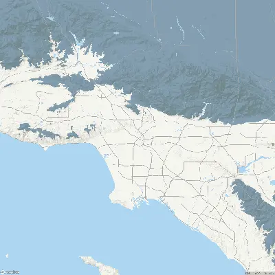
Southern California’s foothills and even some desert areas are all within reach of this week’s snow storm. The map below offers a view of the region by elevation.
Elevation (in feet)
0
500
1,000
1,500
2,000
2,500
3,000
3,500+
How unusual is low-elevation snow?
Low-elevation snow in California has always been a rare sight, but not impossible.
In 1989, the last and only other time a blizzard warning was issued for the L.A. area, up to 5 inches of snow fell in parts of the San Fernando and Simi valleys. The last time downtown Los Angeles saw more than tiny amounts of snow was on Jan. 15, 1932, when the weather service recorded 2 inches there.
In the 20th century, air masses that would sometimes bring significant amounts of snow to Sacramento, San Francisco and Los Angeles were both colder and drier than the current pattern. That’s because colder air tends to pick up less moisture through evaporation.
This week’s storm, Swain said, hits a sweet spot.
“This air mass is about as cold as you can get with one that’s still moist enough to produce substantial precipitation,” he said. “In our warmed climate, I would argue this is probably about as cold as we can get, with moisture in the air.”
Had this exact weather pattern played out 50 or 60 years ago, Swain said, “we might have been talking about widespread sea level snow.”
“If this air mass near the surface was a degree or two colder, that’s all it would have taken to produce snow in downtown Sacramento and downtown San Francisco, and maybe even Los Angeles. But it’s not.”
This air mass is about 2 or 3 degrees too warm to dust Southern California’s sandy beaches with snow. “And that’s about how much California has warmed since the last time there was widespread sea level snow in California.
“It really has become just extremely difficult to see that pattern,” Swain said. “I’ll never say never, but the odds are certainly lower today than they used to be and they were already quite low to begin with.”
Times staff writers Hayley Smith, Grace Toohey and Paul Duginski contributed to this report.