Here’s where more than 7,500 buildings were destroyed and damaged in California’s wine country fires
UPDATED Oct. 25, 2017

The wildfires that ripped through Northern California this month destroyed at least 8,400 homes and buildings, according to state officials. Using satellite imagery and data released by Cal Fire, we’ve mapped over 7,500 damaged and destroyed structures. The scope and scale of damage is among some of the worst from wildfires in state history.
The bulk of the destruction can be found in Santa Rosa, where the Tubbs fire ripped through major residential areas on Oct. 8 and 9.
Deadliest California wildfires

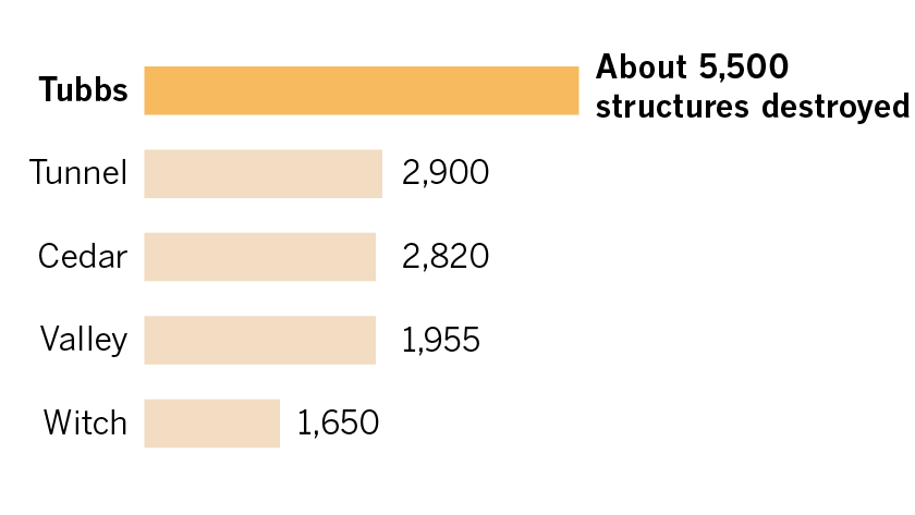
Most destructive California wildfires
Documenting the destroyed and damaged structures requires coordination across government agencies, who must not only identify these structures before evacuees can return home, but must assess the loss in property value as well.
The estimated total insured losses for the Northern California fires stood at $1.045 billion, according to preliminary figures released Thursday by State Insurance Commissioner Dave Jones. Here's what we know about the destruction in the Northern California fires so far:
Tubbs fire
Satellite image analysis by The Times combined with data collected by Cal Fire and Sonoma County shows the Tubbs fire destroyed or damaged at least 5,500 structures alone.
The Tubbs fire began Oct. 8 and grew to over 36,000 acres. As of Monday, crews had it 94% contained.
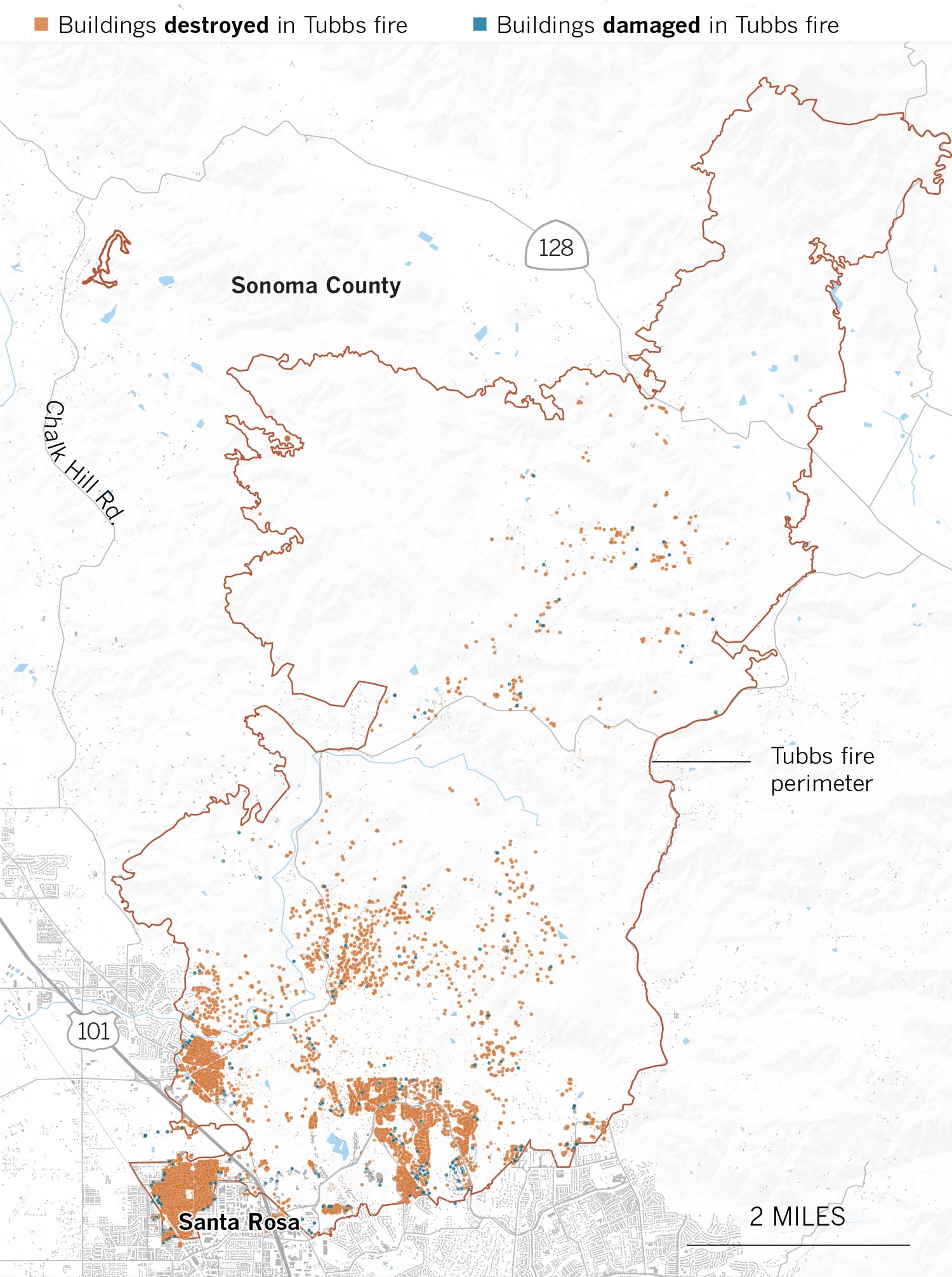
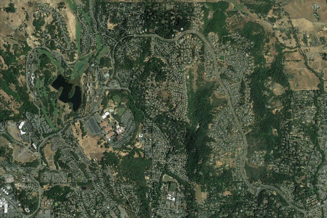
More than 1,500 homes were destroyed in the mountainous area north of Santa Rosa, but the fire hit the city and surrounding area the hardest. Most of the damage occurred in three areas: Coffey Park; Fountaingrove, located in northern Santa Rosa; and Larkfield-Wikiup, about five miles north of Santa Rosa.
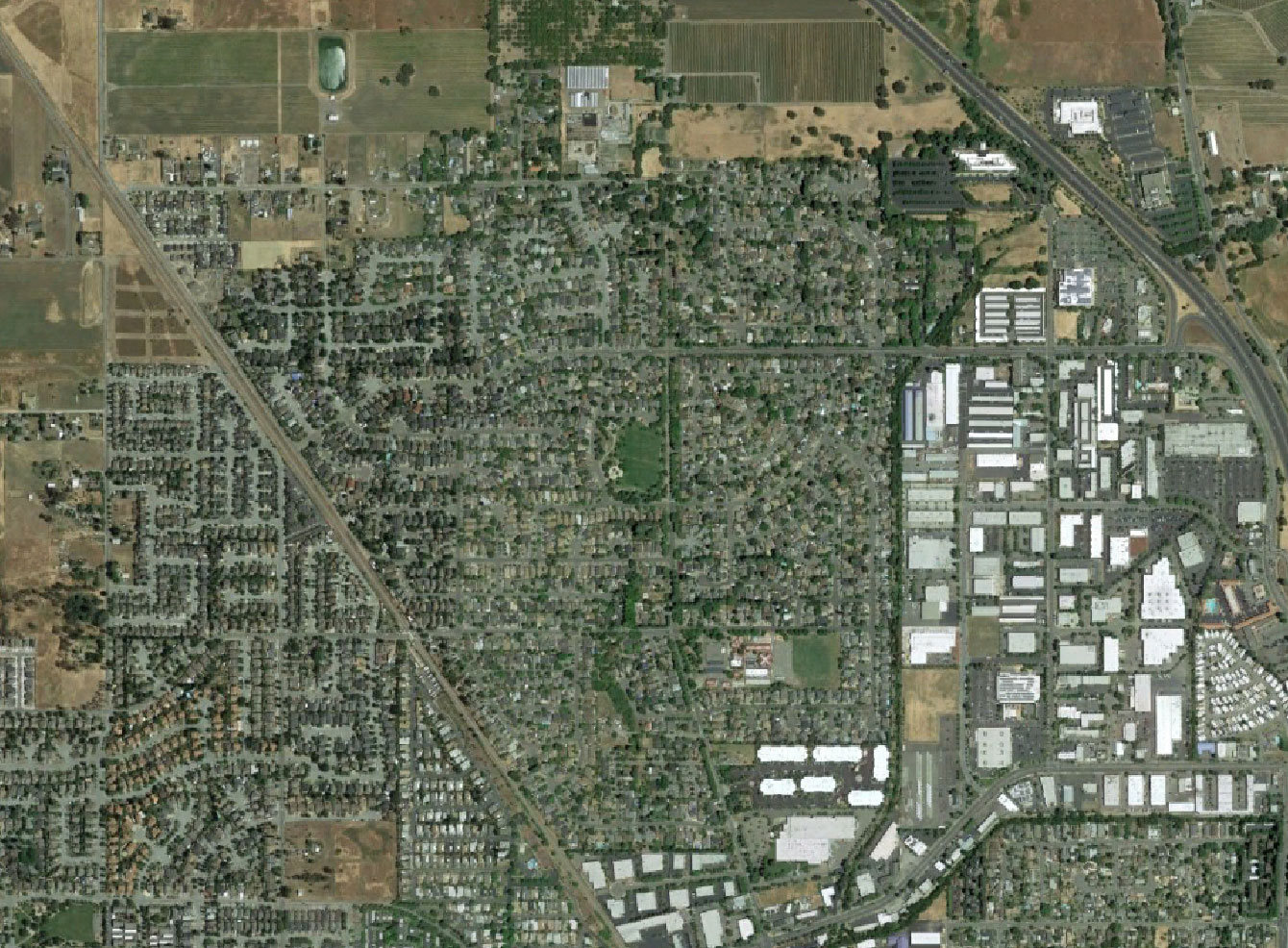
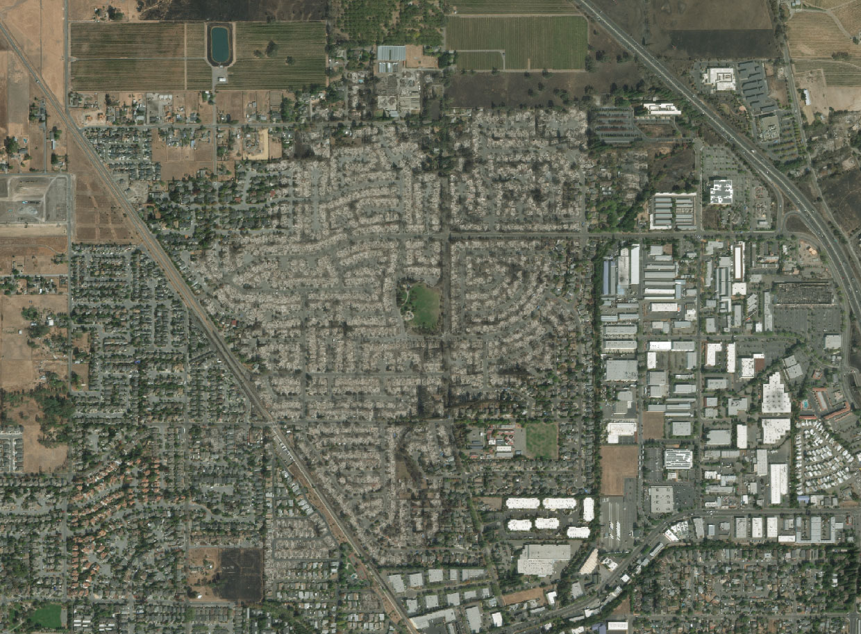
Coffey Park

Fountaingrove

Larkfield-Wikiup

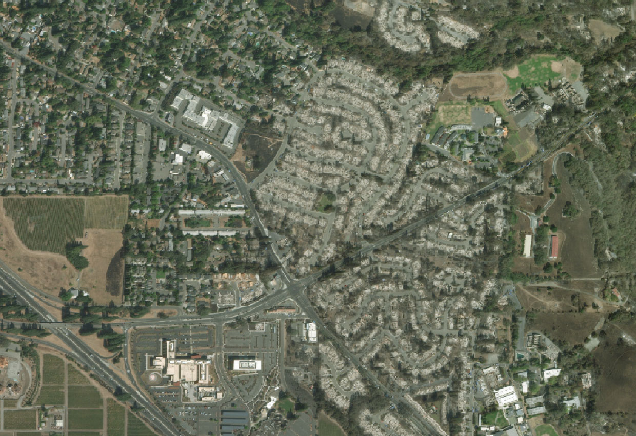
Coffey Park
The Coffey Park area, which quickly went up in flames in the early morning of Oct. 9, was one of the most densely populated areas in Santa Rosa affected by the fire. About 1,500 homes were destroyed in the small neighborhood. Structures that appear to still be standing may have fire or smoke damage that could prevent homeowners from moving back in.

Fountaingrove
Almost 1,800 structures were destroyed in the Fountaingrove area, located in the northernmost part of Santa Rosa. The fire also destroyed a new, $4-million firehouse, according to the Santa Rosa Press-Democrat.


Larkfield-Wikiup
The fire also tore through the Larkfield-Wikiup area, an unincorporated community about five miles north of Santa Rosa, destroying about 750 structures.


Pocket fire
The Pocket fire, which began in the early morning on Oct. 9, burned 17,537 acres and was 90% contained as of Tuesday. The fire broke out in a sparsely populated area near Geyserville, so structural damage was limited, and there were no fatalities in the Pocket fire. According to data released by Cal Fire, out of the close to 100 structures within the perimeter, six were destroyed and two were left damaged.


Atlas Fire
The Atlas fire burned 51,624 acres and was 96% contained as of Tuesday. It began on Oct. 8, racing down Atlas Peak mountain and killing six people. Mapping from Cal Fire and Napa County estimates that over 800 structures were destroyed or damaged, but damage assessments are still ongoing. Much of the destruction was concentrated in areas northeast from the city of Napa, wreaking havoc on nearby small communities, wineries and resorts.

Silverado Oaks / Vichy Springs area
The fire caused the most concentrated destruction in area north of Vichy Springs, a few miles north of Napa, near the Silveardo Resort and Spa. This area is surrounded by vineyards and large golf courses, which may have prevented the fire from spreading further.


Nuns fire
The Nuns fire, which began on Oct. 8, merged with several smaller fires, became the largest of the wine country fires and burned over 56,000 acres. It spread to both Sonoma and Napa County, killing two people. As of Tuesday, it was 93% contained. Damage assessment estimates from both counties show that close to 1,000 structures have been destroyed or damaged in the fire. The fire did not reach the city of Sonoma, but impacted several smaller communities and wineries.
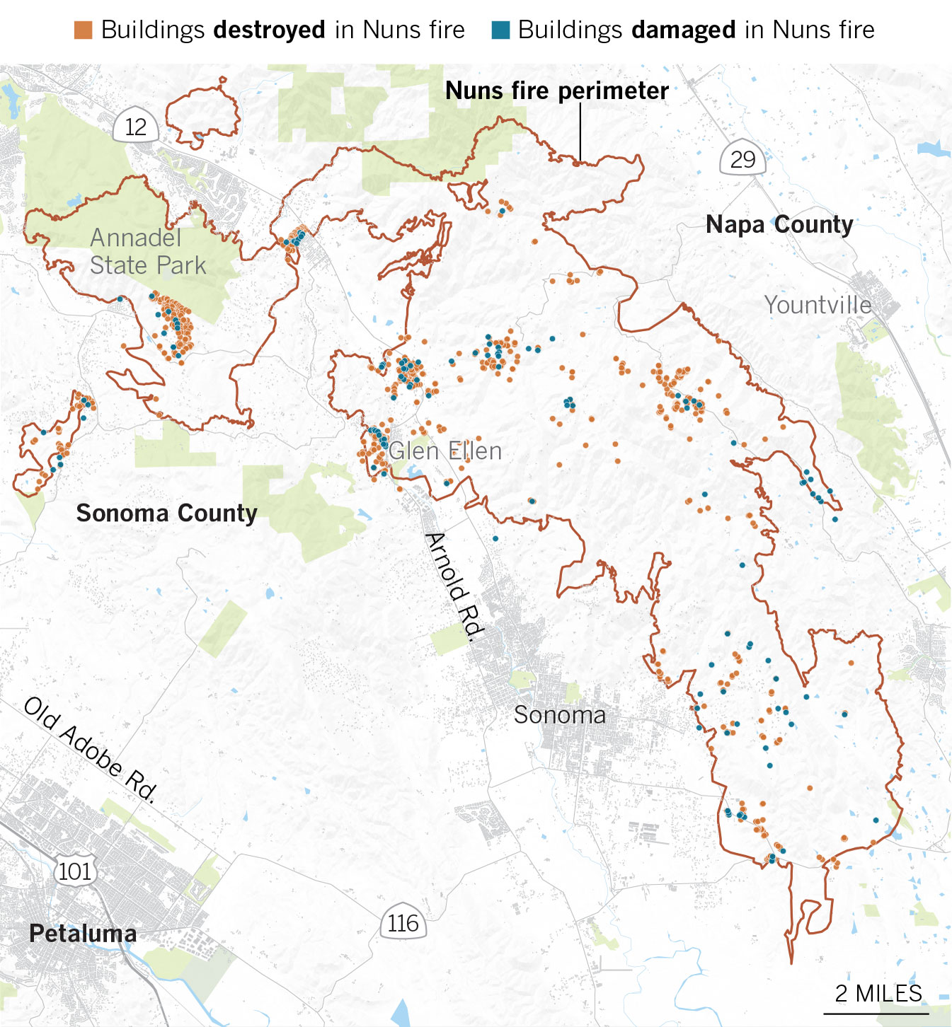
Annadel State Park
Some of the most concentrated structure damage occurred right outside Annadel State Park, a few miles east of Santa Rosa, and in the nearby Kenwood community.


The California Department of Forestry and Fire Protection, along with agencies in Sonoma and Napa County, are continuing to document the total number of structures that have been destroyed and damaged in the Northern California fires. This page will be updated as more information becomes available.
Oct. 24, 2:00 p.m.:This article was updated to include information about the Pocket fire.
Oct. 25, 2:30 p.m.:This article was updated to include information about the Atlas fire and Nuns fire.
The original article was published on Oct. 23 at 6 p.m.
Sources: Map imagery from Digital Globe, Google Earth, Mapzen and OpenStreetMap. Building data from Cal Fire, Napa County and Sonoma County.
Credits: Additional reporting by Lorena Iniguez Elebee, Len De Groot, Raoul Ranoa, Paul Duginski, Ally Levine and Swetha Kannan