How the Maui fires consumed Lahaina

Banyan tree among a large burned building with a charred boat in the foreground
The iconic banyan tree stands among the rubble of burned buildings days after a catastrophic wildfire swept through Lahaina. (Robert Gauthier / Los Angeles Times)

PUBLISHED

UPDATED

twitterfacebookenvelope

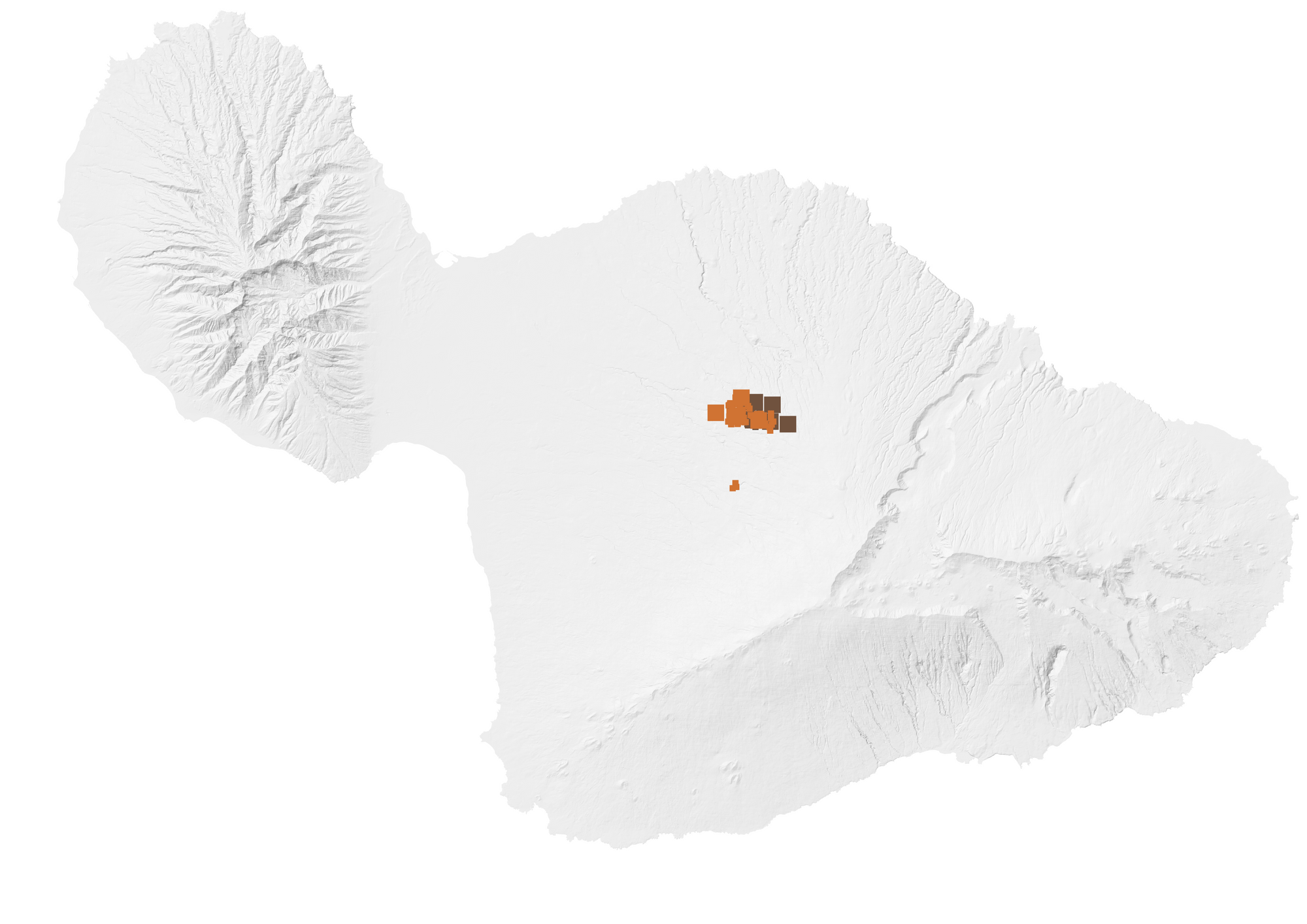
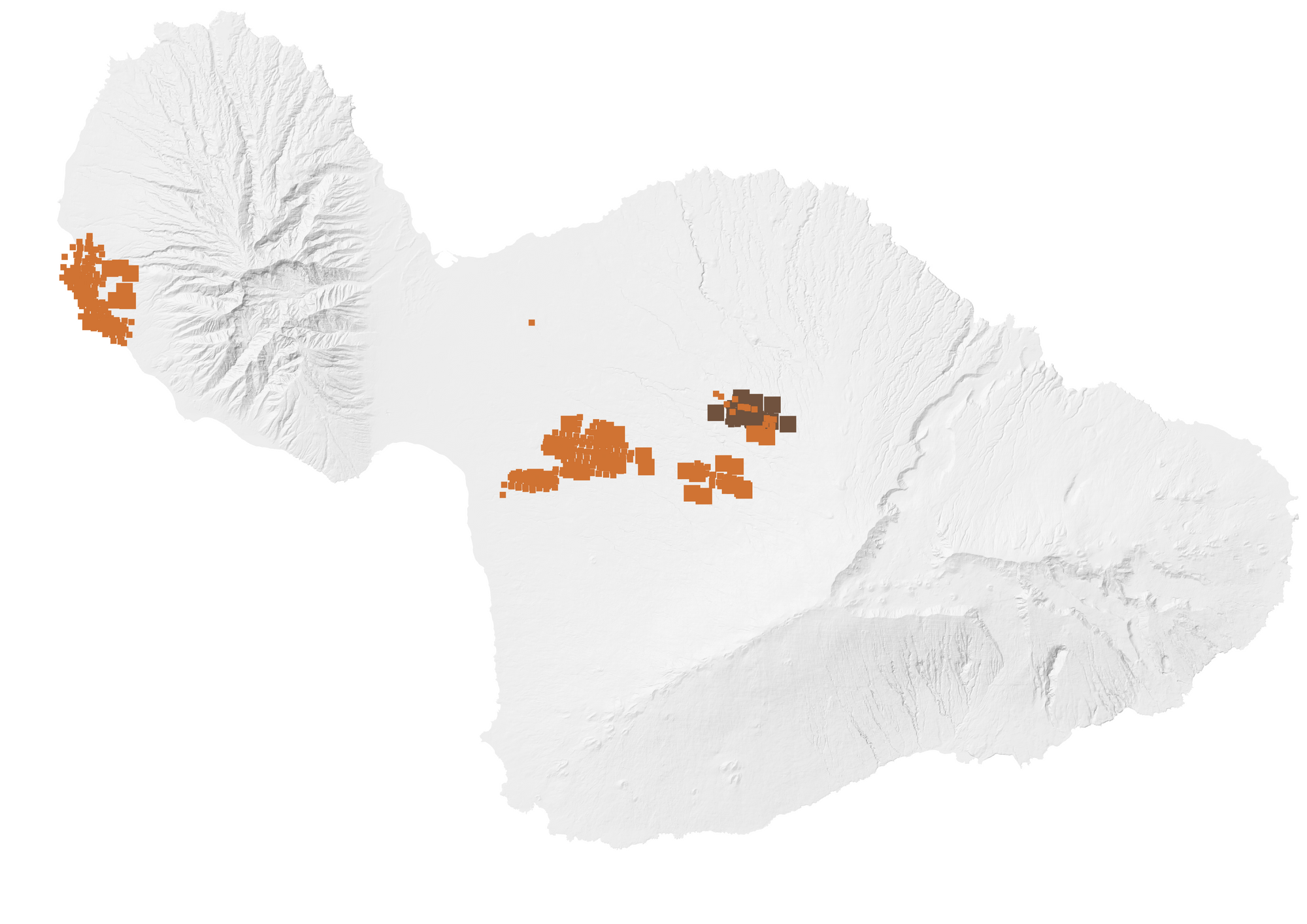
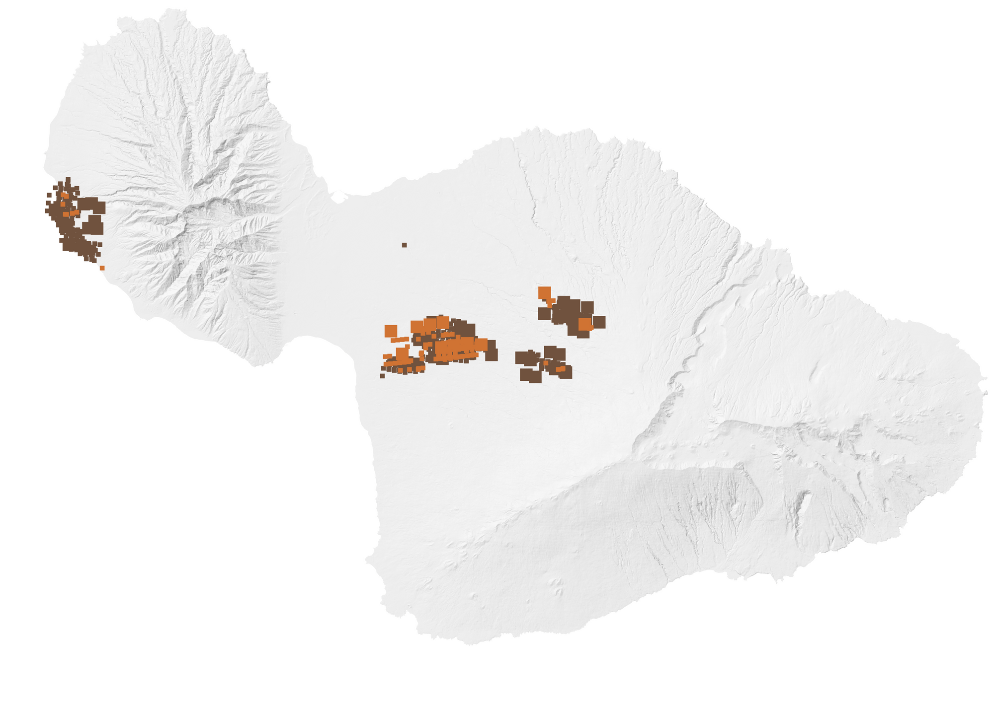
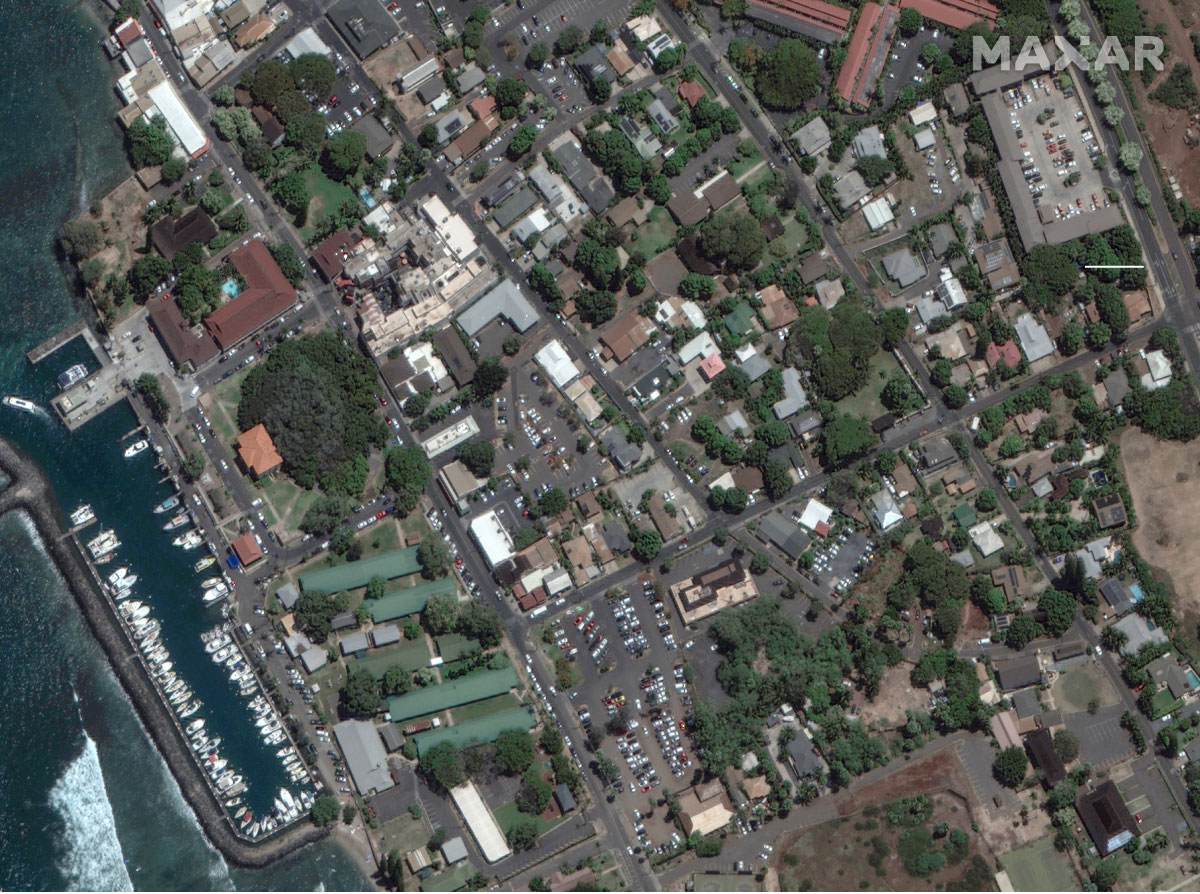
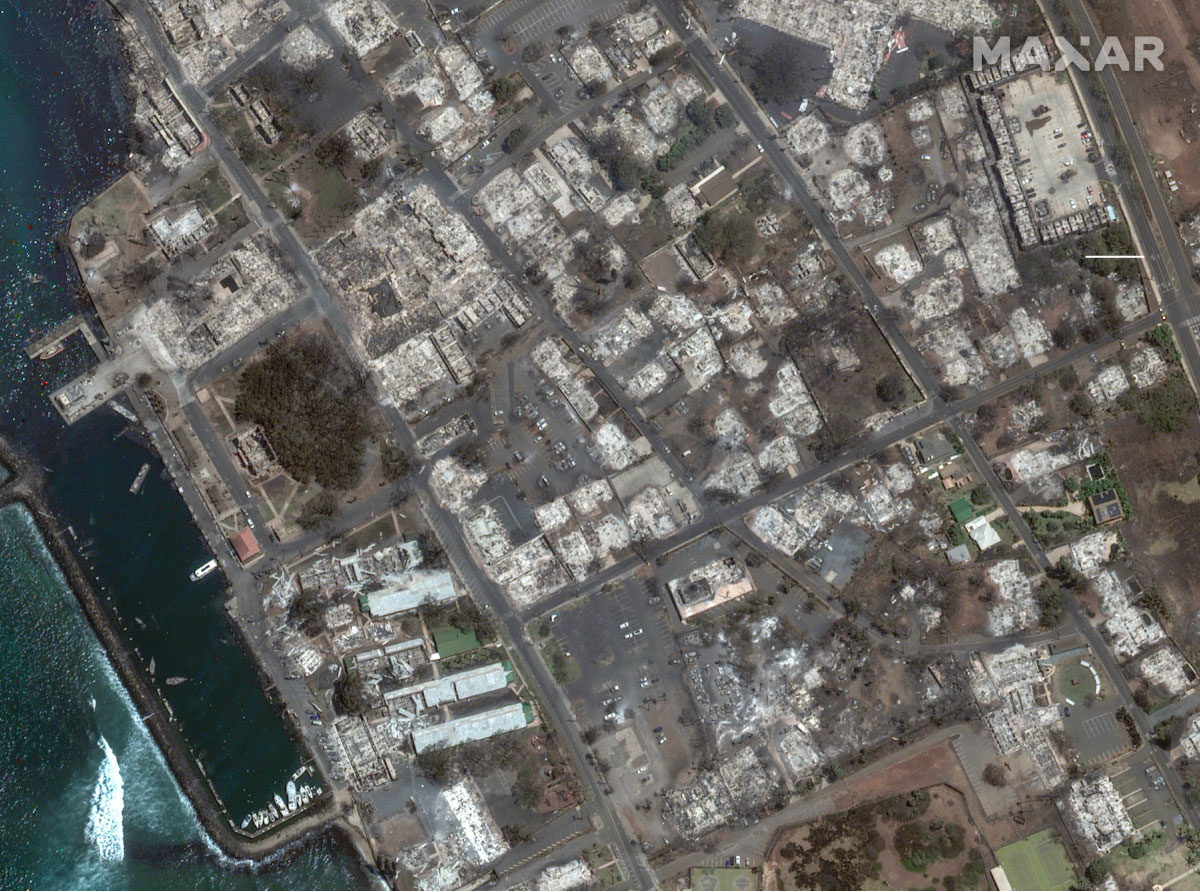
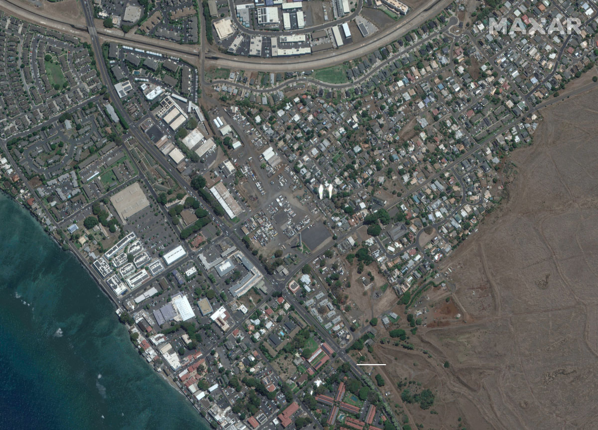
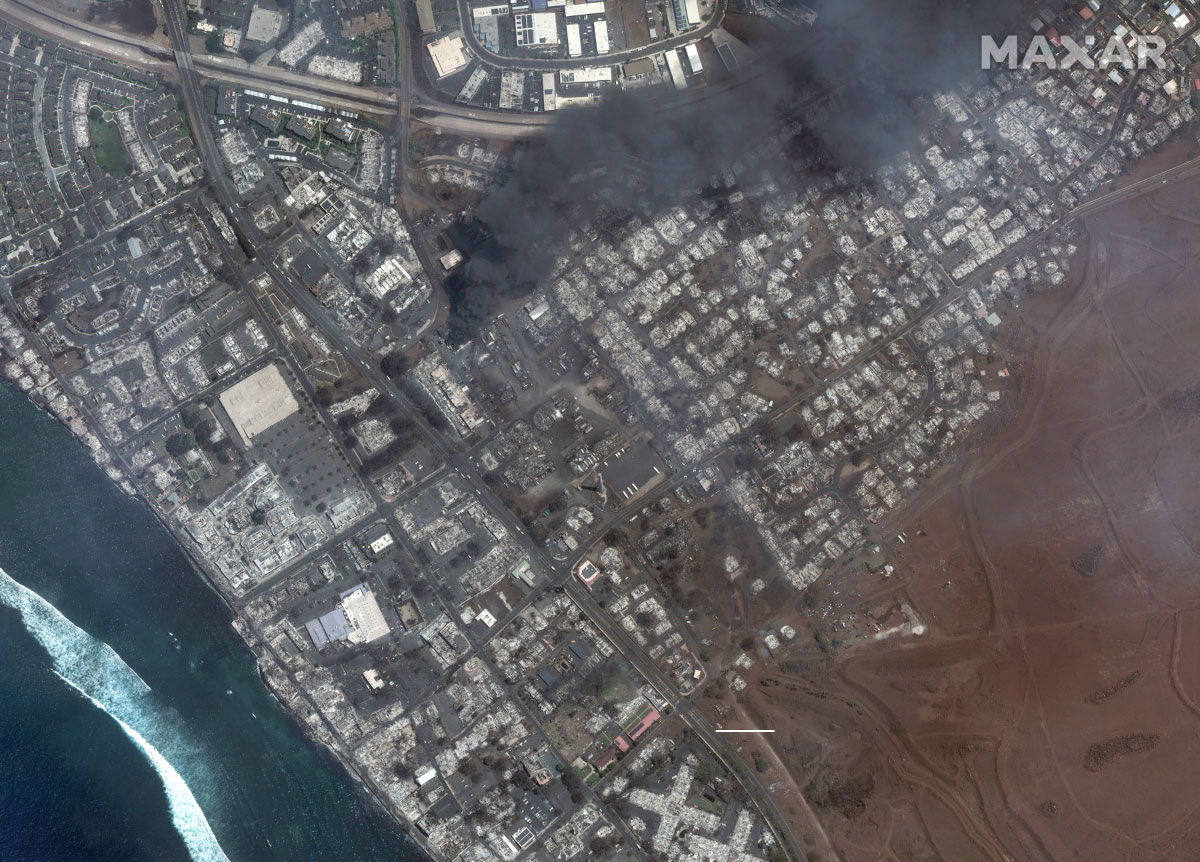
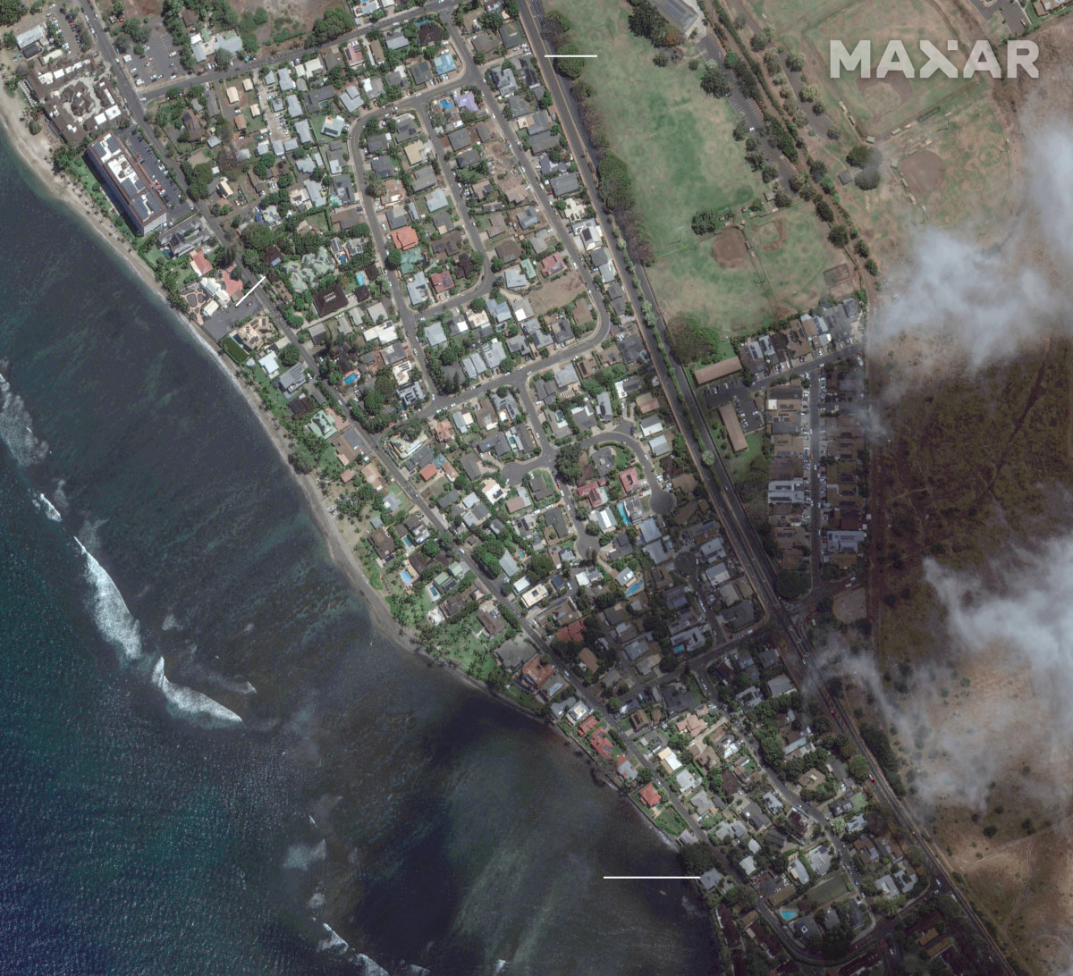
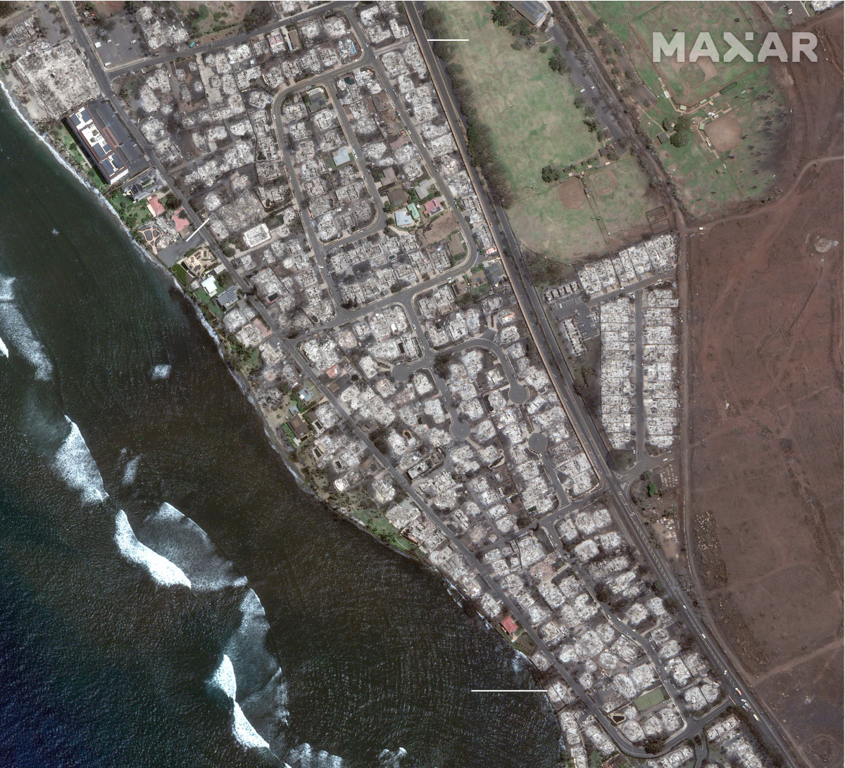
The fires on Maui are the deadliest in 100 years of U.S. history.

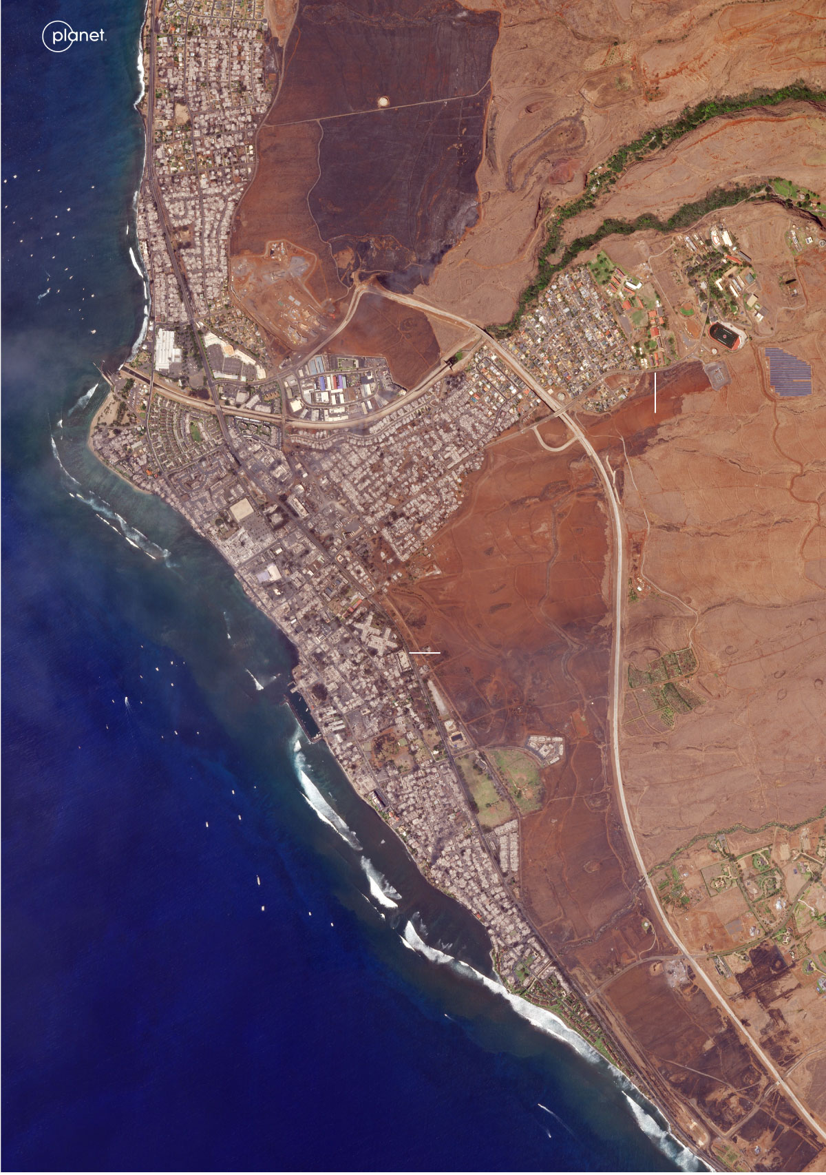
Officials have confirmed the deaths of more than 100 people, with about 1,300 still missing. In Lahaina, West Maui, more than 2,200 homes, apartment buildings and other structures were damaged or destroyed.

The first warning signs came more than a week ago, when on Aug. 4 the National Weather Service said to expect dry weather and high fire danger in Hawaii the following Monday into Wednesday as a system of low pressure — namely, a hurricane — moved from southeast of Hawaii to southwest of the state, while high pressure remained to its north.

Because air moves from high pressure to low pressure, the weather setting would subject the state to fire weather, the agency reiterated Sunday, with Hawaii caught between wind blowing from northeast of the state to its southwest – similar to Santa Ana wind events in Southern California.

Maui County warned residents in a Facebook post that “strong winds may lead to property damage. Winds may blow down trees, power lines and roofs. Power outages are possible.”

What happened next would result in the destruction of a one-time capital of the Hawaiian kingdom.

Tuesday, Aug. 8 at 12:22 a.m.

A brush fire ignites and begins to spread in central Maui. Strong winds, with gusts of up to 80 mph, made the area unsafe for helicopter operations.

3:45 a.m.

Later dubbed the Upcountry fire, the fire prompts evacuations in various parts of Kula, on the western side of Maui’s eastern volcano. By late morning, it would burn mostly pastureland.

6:37 a.m.

About 20 miles away, this time on the western side of Maui’s western volcano, another fire starts near Lahaina Intermediate School on the town's northeastern edge, at its highest elevations. Evacuations in the immediate area were ordered within three minutes.

10 a.m.

Officials say publicly that the Lahaina fire is 100% contained, although it did warn of power outages limiting the ability to pump water and reported a downed electric line in the area.

Through the late morning and early afternoon, the attention appears to focus on the Upcountry fire. State and county firefighters, tankers and heavy equipment are focused there, and Maui County authorities warn that wind conditions there are so intense that “the fire can be a mile or more from your house, but in a minute or two, it can be at your house.”

In Lahaina, there were reports of power outages and downed communications – not unusual during high winds. But suddenly, by mid-afternoon, witnesses in Lahaina started seeing smoke worsening.

Hot spots from fire, hot smoke or other sources are captured by satellites as they pass over Hawaii throughout the day. While the combined satellite data cannot show exactly what burned, it provides a clear picture of the fire areas.

Active fire footprint
Previous detection

Tuesday, Aug. 8, 1:45 to 2:34 a.m.

Upcountry fire

Lahaina

Kula

5 MILES

MAUI

Aug. 8, 10:57 a.m. to 2:35 p.m.

Aug. 8, 9:50 p.m. to Aug. 9, 3:06 a.m.

Lahaina fire

Aug. 9, 10 a.m. to 2:18 p.m.

Shaded areas represent cumulative fire footprints detected by satellites orbiting the Earth roughly every 12 hours.

NASA FIRMS

3:30 p.m.

The Lahaina fire flares up again and begins burning a housing development on the highest part of town, near the school.

4:30 p.m.

High winds push embers downhill and to the south and west, toward the Kahoma area, on to the coast and the heart of town. More homes catch fire and witnesses hear a gas station explode.

4:45 p.m.

Multiple road closures are reported, along with bottlenecks on the northbound highway. Fleeing residents in cars are trapped in flames. Many died in their cars.

5:45 p.m.

The Coast Guard began receiving reports of people in the water needing rescue after fleeing from fire and smoke. Initial reports suggest as many as 100 people are in the water, and people struggle to breathe amid heavy smoke and from being pulled to sea.

Later that evening, Maui County officials urge people to shelter in place “if you are not in an impacted area.” Authorities say “road closures are occurring as needed due to zero visibility,” and that the 911 system in West Maui is unavailable.

At 3:15 a.m. the next day, the high wind warning ends.

Eventually, almost all of Lahaina was reduced to ash.

Satellite imagery captured over Maui on the afternoon of Aug. 9 shows the extent of the loss.

Satellite imagery captured on Aug. 9 shows burned buildings throughout the town of Lahaina

Lahaina Intermediate School

Lahaina Bypass

Honoapiilani

Highway

Pacific

Ocean

Satellite imagery captured on Aug. 9 shows burned buildings throughout the town of Lahaina

Lahaina Intermediate School

Honoapiilani

Highway

Lahaina

Bypass

Pacific

Ocean

Aug. 9 2:24 p.m.

(Planet Labs PBC)

Front Street and Banyan Court

Satellite imagery shows burned buildings in Lahaina’s historic Front Street, including a large banyan tree

June 25

Honoapiilani

Highway

Banyan Court

Lahaina

Harbor

Front Street

(Satellite image ©2023 Maxar Technologies)

Satellite imagery shows burned buildings in Lahaina’s historic Front Street, including a large banyan tree

Aug. 9

Honoapiilani

Highway

Banyan Court

Lahaina

Harbor

Front Street

(Satellite image ©2023 Maxar Technologies)

Lahaina Square and the Kahoma neighborhood

Satellite imagery shows central Lehaina before the fire.

June 25

Kahoma

neighborhood

Lahainaluna Road

Lahaina Square

Shopping Center

Honoapiilani

Highway

(Satellite image ©2023 Maxar Technologies)

Satellite imagery shows the destruction of central Lehaina.

Aug. 9

Kahoma

neighborhood

Lahainaluna Road

Lahaina Square

Shopping Center

Honoapiilani

Highway

(Satellite image ©2023 Maxar Technologies)

Southern Lahaina

An annotated satellite image from June 25 shows the southern area of Lahaina before the fire.

June 25

Honoapiilani

Highway

Lahaina Recreation Center

William K.

Kaluakini

House

Front Street

Lucy Kaiewe

Searle House

(Satellite image ©2023 Maxar Technologies)

Satellite imagery shows the southern area of Lahaina on June 25 and on August 9. The two photos, side-by-side, show the burned areas, including the William K. Kaluani House and the Lucy Kaiewe Searle House.

Aug. 9

Honoapiilani

Highway

Lahaina Recreation Center

William K.

Kaluakini

House

Front Street

Lucy Kaiewe

Searle House

(Satellite image ©2023 Maxar Technologies)

The federal government estimates that the cost to rebuild will exceed $5.5 billion, according to the Pacific Disaster Center and the Federal Emergency Management Agency. At least 4,500 people are in need of shelter.