How the last 20 years of Sierra snowpack stack up, in one graphic
PUBLISHED
UPDATED
The Sierra snowpack has reached its seasonal peak.
The snowpack plays an important role in providing water to millions of Californians. Throughout the winter months, snow accumulates on the high peaks of the Sierra Nevada and slowly melts in the spring and early summer. The runoff fills dozens of major reservoirs downstream.
Last year’s epic snowpack helped relieve a yearslong drought, reaching an eye-popping 252% of normal on April 8. By that date, the mountains held an average equivalent of 64.2 inches of water.

Aggressive and impactful reporting on climate change, the environment, health and science.
The current snowpack now holds a healthy 28.6 inches of water on average after a series of winter storms alleviated concerns that California was facing a “snow drought.”
The California Department of Water Resources tracks the snow water equivalent in the Sierra using a network of 130 electronic sensors. The system went online in 1990s and began producing daily data in the early 2000s. Before that, officials relied on monthly snow surveys to measure the snowpack.
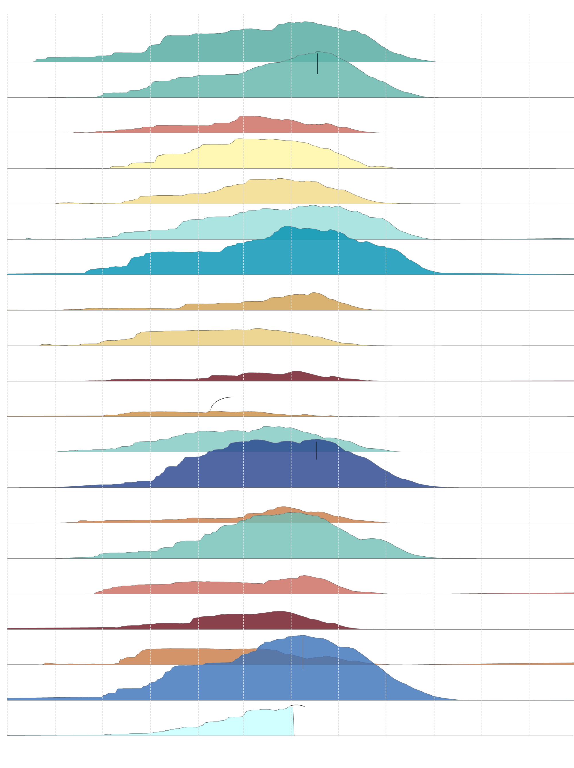
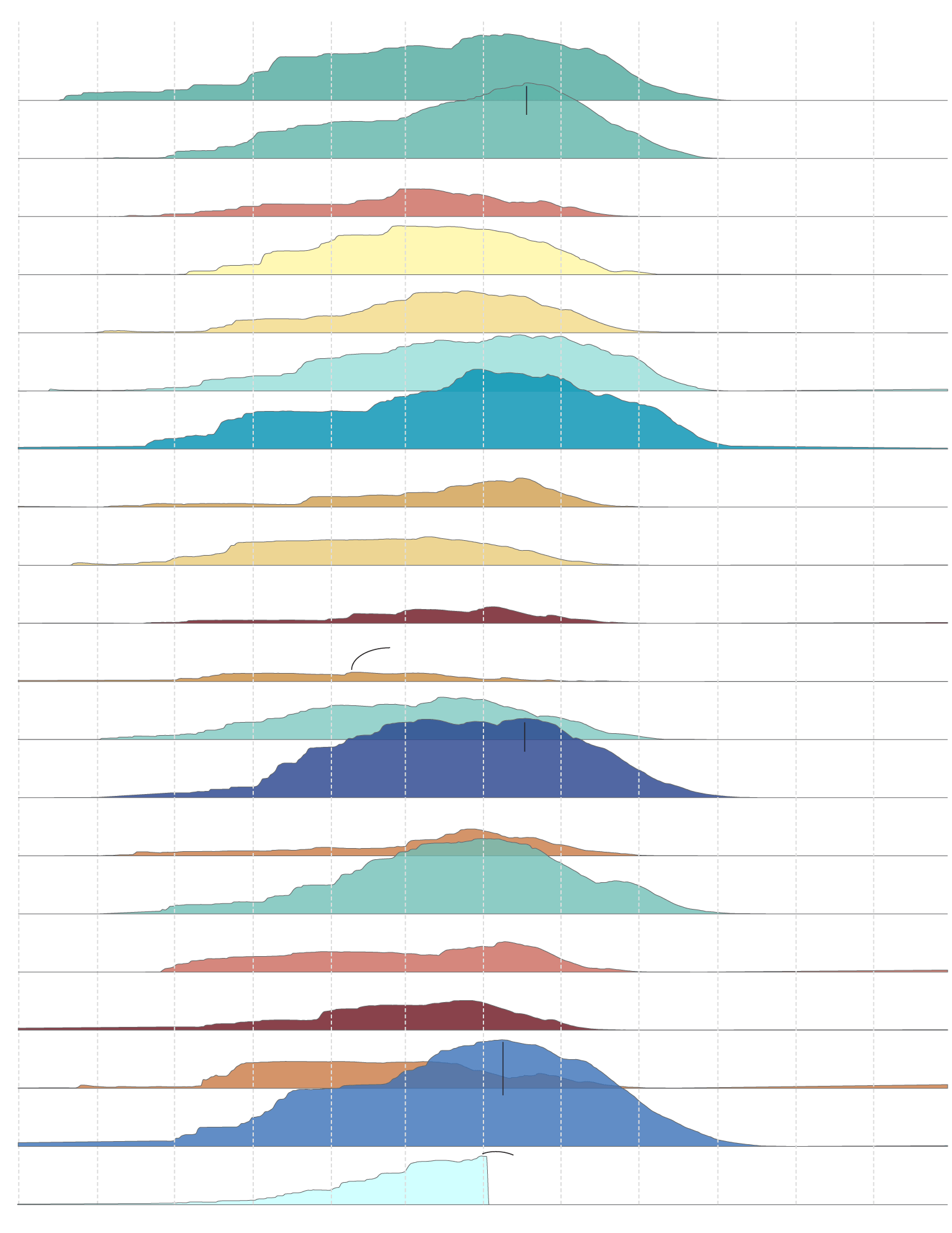
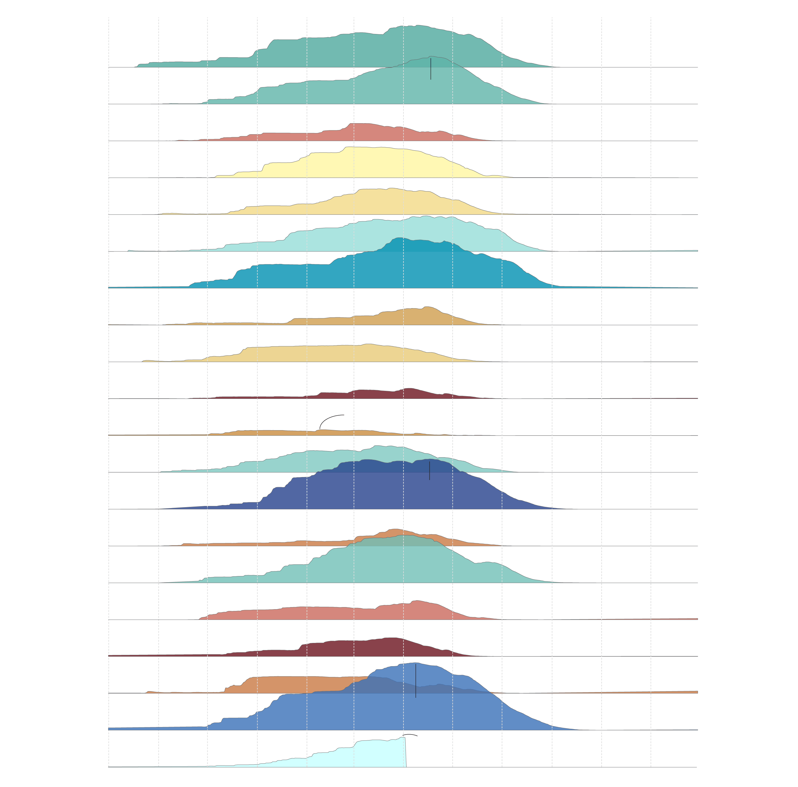
This graphic plots a 20-year history of the Sierra snowpack, showing wet years interspersed with severe droughts.
20 years of Sierra snowpacks
Drier/wetter conditions
Oct.
Nov.
Dec.
Jan.
Feb.
March
April
May
June
July
Aug.
Sept.
2005
Snowpack peaked at 45.5 inches on April 18, 2006
2006
2007
2008
2009
2010
2011
2012
2013
2014
The smallest modern snowpack came in at 5.6 inches on Feb. 9, 2015
2015
2016
47.8 inches
April 17, 2017
2017
2018
2019
2020
2021
2022
64.2 inches
April 8, 2023
2023
28.8 inches
March 31, 2024
2024
Oct.
Nov.
Dec.
Jan.
Feb.
March
April
May
June
July
Aug.
Sept.

Oct.
Dec.
Feb.
April
June
Aug.
2005
Snowpack peaked at 45.5 inches on April 18, 2006
2006
2007
2008
2009
2010
2011
2012
2013
2014
The smallest modern snowpack
came in at 5.6 inches on Feb. 9, 2015
2015
2016
47.8 inches
April 17, 2017
2017
2018
2019
2020
2021
2022
64.2 inches
April 8, 2023
2023
28.8 inches
March 31, 2024
2024
Oct.
Dec.
Feb.
April
June
Aug.
Oct.
Nov.
Dec.
Jan.
Feb.
March
April
May
June
July
Aug.
Sept.
2005
Snowpack peaked at 45.5 inches on April 18, 2006
2006
2007
2008
2009
2010
2011
2012
2013
2014
The smallest modern snowpack came in at 5.6 inches on Feb. 9, 2015
2015
2016
47.8 inches
April 17, 2017
2017
2018
2019
2020
2021
2022
64.2 inches
April 8, 2023
2023
28.8 inches
March 31, 2024
2024
Oct.
Nov.
Dec.
Jan.
Feb.
March
April
May
June
July
Aug.
Sept.
Oct.
Nov.
Dec.
Jan.
Feb.
March
April
May
June
July
Aug.
Sept.
2005
Snowpack peaked at 45.5 inches on April 18, 2006
2006
2007
2008
2009
2010
2011
2012
2013
2014
The smallest modern snowpack came in at 5.6 inches on Feb. 9, 2015
2015
2016
47.8 inches
April 17, 2017
2017
2018
2019
2020
2021
2022
64.2 inches
April 8, 2023
2023
28.8 inches
March 31, 2024
2024
Oct.
Nov.
Dec.
Jan.
Feb.
March
April
May
June
July
Aug.
Sept.
When stacked up, the last two decades reveal California’s quintessential pattern of bust and boom. When California faces long dry spells, it takes large amounts of snow and rain to reverse the trend.
This cycle is projected to become more extreme as the planet warms. With human-caused climate change, higher temperatures are intensifying droughts, and the state’s average snowpack is projected to shrink significantly as temperatures continue to climb.
Tracking the rise and fall of California’s snowpack over the past two decades provides a long-term view of the state’s highly variable climate and the patterns that dictate our water fortunes.