Here’s how much it has rained in California
UPDATED
A powerful atmospheric river hit California on Sunday, pouring 2.5 inches of rain over the state during a five-day wet spell that broke local precipitation records in some parts of the Southland.
The storm initially brought heavy winds and widespread power outages to the Bay Area and Central Coast before “parking” over Southern California, where it inundated streets and caused landslides in the Hollywood Hills and Santa Monica Mountains. At least nine people have died in storm-related incidents.
The storm – supercharged by El Niño and climate change – is the largest so far in California’s wet season. In a typical year, a few atmospheric river events can deliver 30% to 50% of the West Coast’s annual rainfall.
Last year, a total of 31 atmospheric rivers pummeled the state in a seemingly endless deluge. The storms – and resultant Sierra snowpack – helped relieve years of drought conditions. How did this storm compare to last year’s downpours? These graphics explain.
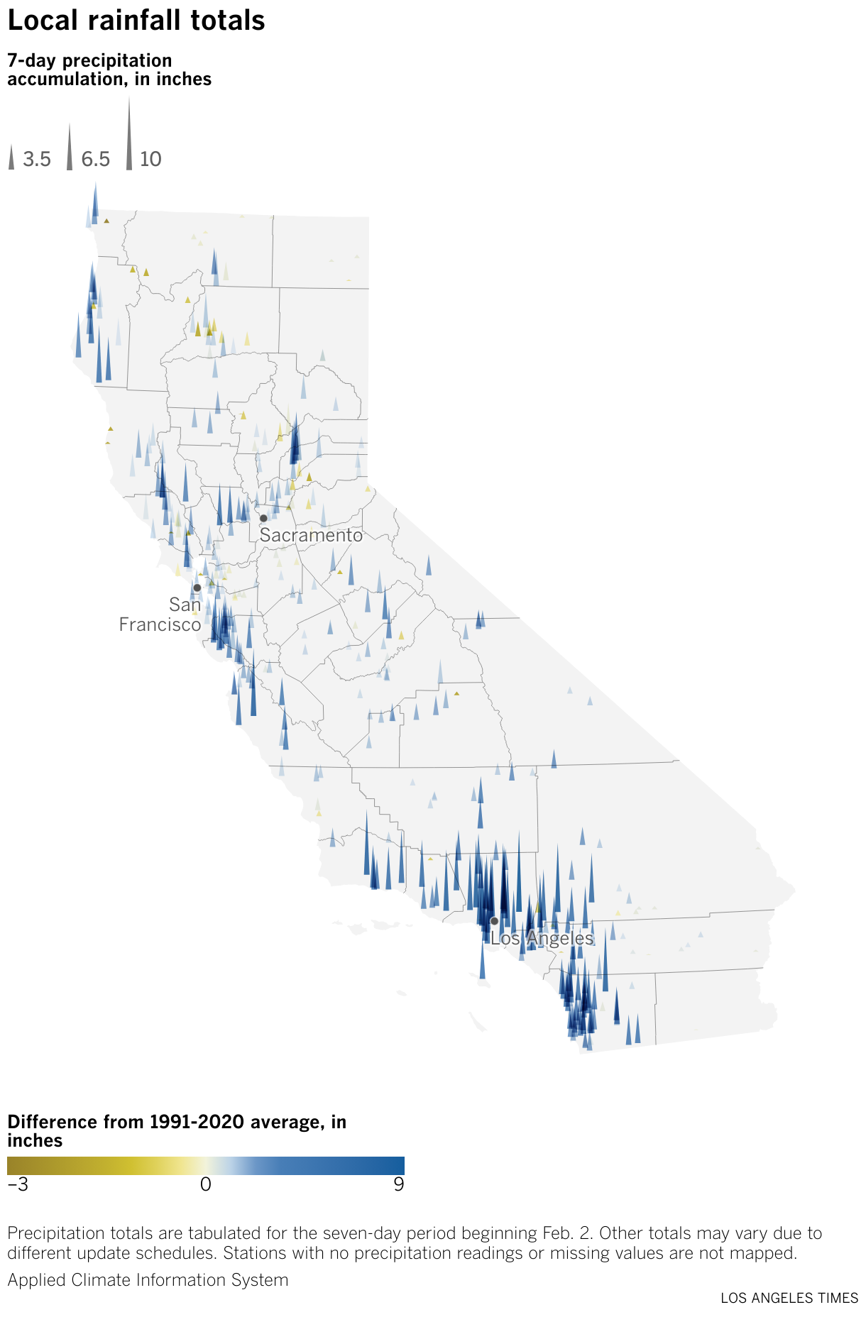
The storm has brought above-average rainfall across the state
As the rain picked up Sunday throughout the state, many areas across Greater Los Angeles received more than 6 inches in the first 72 hours.
For reference, an inch of rain falling over one square mile is equal to more than 17 million gallons of water, enough to fill 26 Olympic-sized swimming pools.
Over the last week, downtown Los Angeles and other stations in the area totaled up to nine times the average rainfall for this time of year. Downtown San Francisco recorded nearly twice the average. On Sunday night, heavy rains forced officials to close the Santa Barbara Airport due to flooding on the airfield.
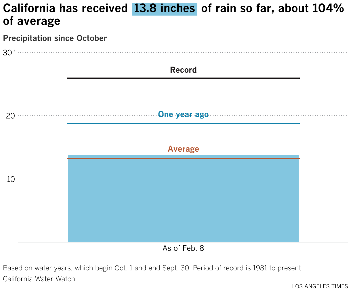
California’s water year saw a slow start
Since the start of the water year on Oct. 1, California had seen relatively little rain and snow.
After the storm, total precipitation for the year caught up to the historical average, which state water managers set between 1981 and the present. The accumulation is still well below the total from this time last year.
Significant storms in December and the current torrential rains may mean little for the state’s water supplies. Most of the precipitation seen thus far has fallen as rain over the coast instead of snow over the mountains.
California traditionally receives about 30% of its water from the Sierra snowpack, which as of Friday stood at more than 75% of its average level for this time of year. Water managers have warned this “snow drought” could persist into the spring.
Don’t ditch the umbrella yet
Many Californians have grown accustomed to cloudless skies due to the periods of prolonged drought and the region’s Mediterranean climate, which means most of its rain falls during the winter months into March.
In recent seasons, the state’s wettest months have been in January and March.
Last summer’s Tropical Storm Hilary brought nearly 3 inches of rain to the South Coast hydrologic region, which includes much of coastal Southern California – the most for a single day that year. This February's storm accumulated nearly 6 inches of rain in five days.
The Central Coast’s highest daily rainfall total last year was 3.5 inches on Jan. 10. In the five days of rain this month, the region received 2.5 inches. Last year, deluges returned in March and brought devastating floods to the town of Pajaro in Monterey County.
While Southern Californians weathered an August tropical storm, Bay Area residents enjoyed rain-free days for almost a month. On Oct. 25, 2021, the region accumulated 4.5 inches of rain, the most in 20 years. February’s storm brought a total of 3 inches of rain to the region in five days.