L.A.’s monster storm was even worse in some areas than the alarming forecasts

- Share via
Southern California has a complex relationship with the rain.
Many years, we get very little of it. But when the big storm hits, it can bring devastating deluges that instantly alter the landscape and put people in harm’s way.
And that brings us to “Stormwatch,” the vital but sometimes mocked warnings about dangerous weather headed our way.
For days, forecasters raised alarms about potentially life-threatening storms that would dump heavy rain on the region. It would be the latest in a winter of extreme weather that brought once-in-1,000-year flooding to Ventura and San Diego County.

Many took the warnings seriously. A few scoffed.
But in the end, the grim forecast turned out to be largely right — and in some cases actually underestimated the rainfall.
The National Weather Service warned of an astonishing 6.37 inches of rain for downtown Los Angeles, and, incredibly, 8.66 inches fell for the four-day period ending late Tuesday — more than 60% of downtown L.A.’s annual average rainfall.
Elsewhere in the region, Long Beach was predicted to get 6.43 inches; 7.34 inches fell. Santa Clarita was expected to get 6.64 inches; 7.72 inches dropped. Northridge expected 6.74 inches; it got 7.81 inches. Westlake Village was on tap to get 5.74 inches; it got 7.61 inches. In Pomona, a 6.67-inch forecast gave way to 9.41 inches of rainfall.

Other areas saw estimates a little under expectation, but still within range of a memorable storm. Pasadena has so far received 8.61 inches of rain — impressive, but shy of an eye-popping forecast of 9.75 inches. Ojai was expecting to receive 7.16 inches but got 4.48 inches so far.
The accuracy of the forecast came in part because the configuration and orientation of this storm — while rare for Southern California — is familiar to weather officials so they could model it with a certain level of confidence.
Once there are forecasted totals in the lower-lying cities of “5, 6, 7, 8 inches, the impacts are pretty much the same” in terms of flooding and landslide risk, said meteorologist Ryan Kittell of the National Weather Service’s Oxnard office.

The mountain and foothill forecasts were also spot on, with forecasts of 8 to 14 inches of rain; by Tuesday night, the Sepulveda Pass had seen 13.02 inches of rain; Bel Air, 13.04 inches; and Cogswell Dam in the San Gabriel Mountains, 13.86 inches.
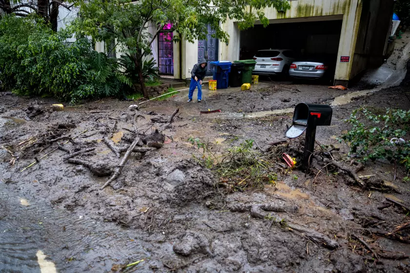
The epic rainfall broke records, caused damage to homes in Hollywood Hills, the San Fernando Valley and the San Gabriel Valley due to sliding mud and debris and left longtime residents stunned.
“In my 35 years of being in this canyon, this is the scariest it’s ever gotten,” said Dennis Hacela, whose neighborhood on Beverly Drive was hard hit.

As Californians face non-stop rain from an atmospheric river this week see how rainfall totals in your area compares to other regions and previous years.
Typically, it’s the San Gabriel Mountains that get the most rain in our storms, and it’s rarer for places such as the Santa Monica Mountains and Hollywood Hills to get that much rain. But the weather service accurately warned of the “potentially historic” nature of the storm across the entire region and the risk of swift moving flows of mud, rocks and other debris.
By contrast, some Angelenos had a different reaction to forecasters after Tropical Storm Hilary marched through Southern California last August. Forecasters issued wide warnings of what could happen, while also noting that the path of the storm was uncertain.
One forecast put Hilary’s center traveling over the eastern edge of L.A. County, but there was also a chance the eye of Hilary could take a western track — a direct hit on the west side of L.A. County, through Rancho Palos Verdes, Santa Monica and Malibu. There was also the possibility of an eastern track, with the eye as far east as directly over the Colorado River.
In the end, Hilary took a slightly eastward track, which ended up producing nearly 3 inches of rain for L.A. — a lot for an August evening but not out of line for a very wet winter day. Hilary’s worst impact hit the Coachella Valley and the high desert, sending torrents of mud into one area of Cathedral City, requiring the rescue of dozens of residents; washing away homes in the San Bernardino National Forest; and causing millions of dollars in damage to Death Valley.
Kittell said more could have been done to discuss the uncertainty about a tropical storm’s path ahead of the arrival of Hilary, which was the first tropical storm to hit the region in decades.
Officials confirmed 9 deaths in the storm statewide, as hazardous weather continued Tuesday, with mud and debris flows in east Los Angeles County.
Part of the difficulty from that situation had to do with Hilary’s novelty — unlike in the Gulf Coast, Southern California has many mountain ranges, and there were many things lacking in the historical record that could give forecasters an idea of what to expect.
By contrast, the storm setup for Southern California starting Sunday — while rare — has been seen before by the National Weather Service meteorologists in Oxnard, helping to narrow down the prediction.
Exactly as anticipated, the core of the low pressure system fueling California’s storm stalled along the coast just off San Francisco. The standard sea level pressure globally is about 1,013 millibars; “usually, when you get just below 1,000 millibars or so is when you start to have a more impactful storm,” and this time, the central pressure got down to 978 millibars, said Dalton Behringer, a National Weather Service meteorologist for the Monterey office.
“It’s just a lot stronger than we normally see,” Behringer said.
The storm also strengthened quite quickly. Adjusted for the latitude for the San Francisco Bay Area, a 17-millibar drop in pressure — over a 24-hour period — at the center of the storm qualifies it as a “bomb cyclone,” and is an indication of how quickly the storm has strengthened. The actual highest drop in pressure seen in this storm easily surpassed that benchmark — falling by 22 millibars over 24 hours, Behringer said.

Los Angeles’ upscale canyon and hillside communities were particularly hard hit by mudslides and flooding from record rain
That helps explain the monster winds that caused hundreds of thousands of customers in Northern and Central California to lose power, causing the downing of power lines, and likely tragically contributed to the deaths of four people — in Santa Cruz, Sacramento and Sutter counties — from falling trees.
The weather service Saturday night issued an unprecedented “hurricane force wind warning” west of Big Sur. Peak Sunday gust reports were impressive and dangerous, clocking in at 102 mph at Pablo Point in Marin County, 98 mph at Loma Prieta in Santa Clara County and 88 mph at Big Sur in Monterey County.
San Francisco International Airport experienced a peak gust of 67 mph; Sacramento and Santa Cruz, 64 mph; Monterey, 60 mph; San José, 51 mph; and Napa, 49 mph.
Because the storm moved winds in a counterclockwise configuration, that meant that Southern California was lined up to get winds from the south and southwest, and would pick up moisture to fuel itself from the tropics. So that’s why forecasters were pretty confident that the region would get hit hard by a lot of rain — the question was which area would get hit the worst.

Los Angeles County flood control network withstands punishing rains -- for now
The initial projections about three to five days ahead of the storm suggested Santa Barbara and Ventura counties would get hit the hardest, but a couple of days ahead of the storm, there were growing indications that Los Angeles County would face the worst. And that ended up being what happened.
“This storm, while it was rare, we’ve had variety like this in my career. And I’ve been here for 20 years,” Kittell said. The storm was exceptional for being stalled over the region for this long of a period, but “we have analogues to compare it to. ... We have seen things like this before.”
Times staff writer Summer Lin contributed to this report.
More to Read


Sign up for Essential California
The most important California stories and recommendations in your inbox every morning.
You may occasionally receive promotional content from the Los Angeles Times.

More From the Los Angeles Times


Podcasts

A series of small-town dog killings was a prelude to the violence committed by one of California’s deadliest serial killers.

The stories behind the most compelling cases from the people who know them best.

German broadcaster DW explores the idea of 15-minute cities — and why the climate-friendly concept is drawing backlash.


