New Jersey braces for brunt of Hurricane Sandy
ATLANTIC CITY -- With forecasters predicting that Hurricane Sandy may slam directly into the coast of New Jersey, Gov. Chris Christie ordered this city’s casinos shut down, barrier islands evacuated, and everyone to stay off the beaches.
Christie told state residents to let emergency officials’ judgment overrule their own.
“How about if we go by this rule? Anything that looks stupid, is stupid,” he advised.
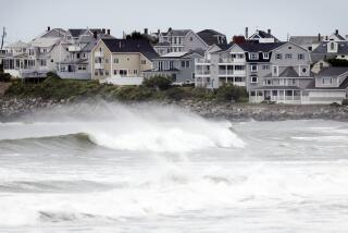
On Sunday morning, heavy surf already was pounding the piers and beaches here, and plywood covered the windows of the souvenir shops and high-rise casinos that line the boardwalk.
Bill Kilcup, in nearby Ocean City for a wedding, stopped for a quick cup of coffee on his way home to New Mexico. He was getting ready to rejoin a slow stream of cars heading west -- away from the oncoming monster storm -- on the Atlantic City Expressway.
PHOTOS: Hurricane Sandy, en route to “Frankenstorm”
“I just want to get out of here,” he said. “Right now we just want to get as far west as we can.”
Schools in parts of New Jersey and Pennsylvania were converted into emergency shelters, and tolls were waived on highways going north and west out of South Jersey.
With the hurricane expected to produce gale force winds for 24 hours or more, mayors and emergency response officials were warning that even inland towns could lose power for a week or more.
“We have to be prepared for the worst here,” Christie told reporters.
“With that much rain and that much wind and with leaves still on the trees, you all know what’s going to happen,” he added. “So let’s not kid ourselves. We’re in for a bit of a haul here if this happens the way they say it’s going to happen.”
Christie said he had little choice but to order evacuations.
“I don’t want people leaving their homes. I would much rather people stay in their homes, but the fact of the matter is, if we’re looking at hurricane force winds on the barrier islands, sustained for 24 hours or more, it is simply unsafe for people to be there.”
The nightmare prospect for the narrow, low-lying barrier islands are storm surges so high that ocean waves meet the bay on the inland side, swamping the islands entirely. With moon-driven high tides this week, forecasters warned of storm surges of 6 to 10 feet along the Atlantic coastline from New Jersey and Long Island up to southern New England.
Forecasters, sounding a little awestruck themselves, said the expected collision of three major weather systems had the potential to produce an epic mess: widespread flooding and beach erosion, high winds and heavy rains, crippling power outages, airline and other transportation snafus lasting days, even snowdrifts in West Virginia and Pennsylvania.
“This is a once in a lifetime storm for the Mid-Atlantic and Northeast,” said Tom Kines, senior meteorologist at AccuWeather. On Sunday morning, he said, the storm seemed to be heading for a landfall near Atlantic City.
But he said Sandy is so sprawling that the exact track is not important.
“Unlike a hurricane where the damage is 50 to 75 miles around the center, the damage from this is going to cover hundreds of miles,” he said.
Since the strongest winds are north of the storm’s center, even Maine could see winds of 50 mph, he said.
“The aerial coverage of the damage is going to be phenomenal,” he added.
ALSO:
Planned Parenthood battles Texas in court over funding
ACLU sues Homeland Security over photos, video restrictions
Texas trooper in chopper shoots, kills 2 suspected illegal immigrants
More to Read
Start your day right
Sign up for Essential California for news, features and recommendations from the L.A. Times and beyond in your inbox six days a week.
You may occasionally receive promotional content from the Los Angeles Times.


