Start your day right
Sign up for Essential California for news, features and recommendations from the L.A. Times and beyond in your inbox six days a week.
You may occasionally receive promotional content from the Los Angeles Times.
California has suffered some destructive earthquakes in the last few decades — among them Sylmar in 1971, Whittier Narrows in 1987, Loma Prieta in 1989 and Northridge in 1994.
All those quakes caused major destruction and resulted in loss of life. But they were not true seismic catastrophes. Much bigger quakes are possible, such as an event along the scale of the 1906 San Francisco quake.
Another example is the 2011 quake under the New Zealand city of Christchurch, which was the subject of a Times report last week. It was a magnitude 6.2, but it became New Zealand’s second-deadliest earthquake on record — killing 185 people and irrevocably destroying large parts of its downtown — because it hit directly underneath the city, one of the nation’s oldest. Experts say a similar quake in California would be much more destructive. Here are some scenarios:
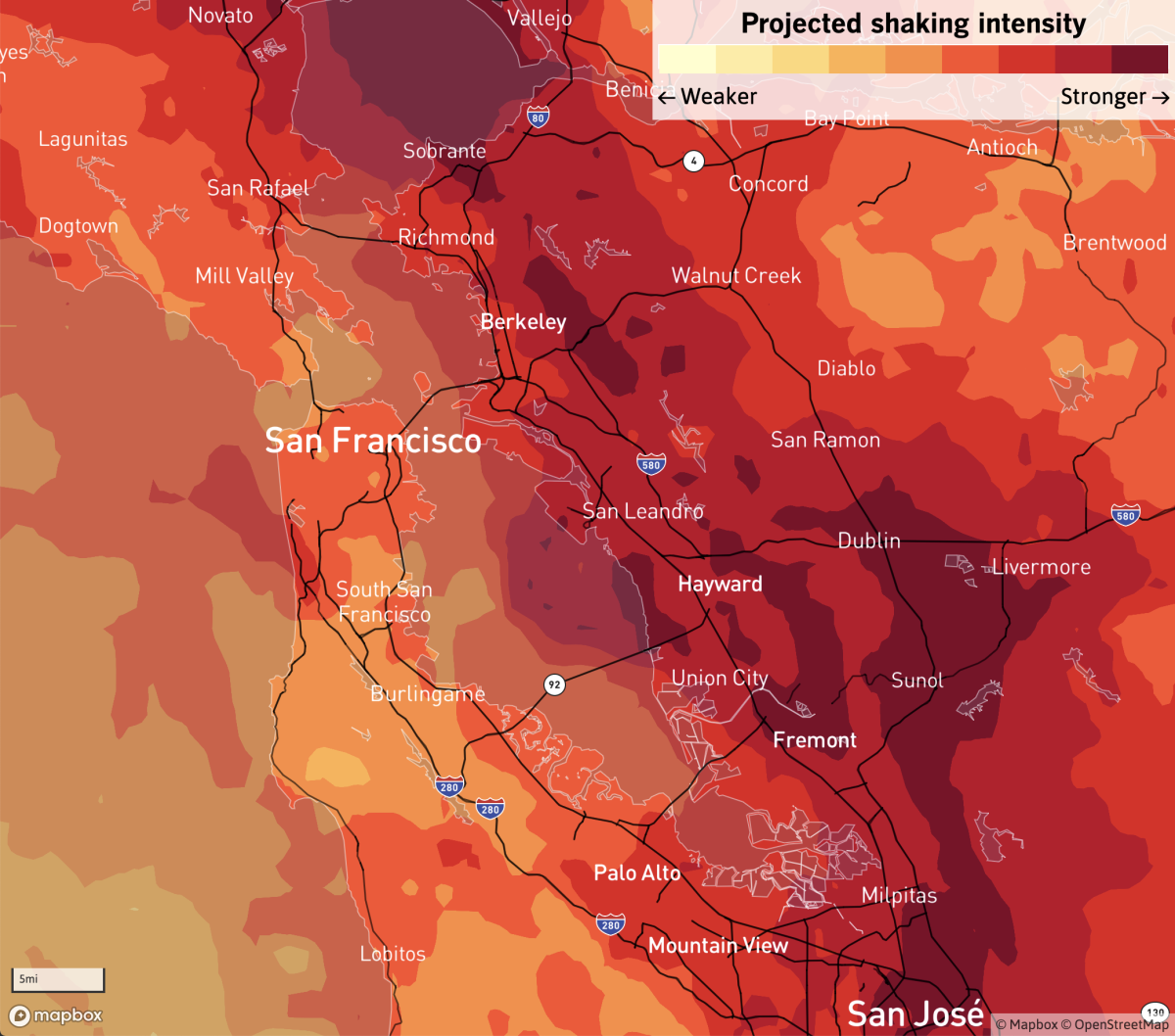
A landmark report in 2018 by the U.S. Geological Survey estimated that at least 800 people could be killed and 18,000 others injured in a hypothetical magnitude 7 earthquake rupturing on the Hayward fault through Oakland, Berkeley, Richmond, Hayward and Fremont.
Hundreds more could die from fire following an earthquake along the ruptured 52-mile section of the fault in this HayWired scenario. More than 400 fires could ignite, burning the equivalent of 52,000 single-family homes, and a lack of water for firefighters caused by old pipes shattering underground could make matters worse, USGS geophysicist Ken Hudnut has said.
“This fault is what we sort of call a tectonic time bomb,” USGS earthquake geologist emeritus David Schwartz said of the Hayward fault. “It’s just waiting to go off.”
The Hayward fault is so dangerous because it runs through some of the most heavily populated parts of the Bay Area, spanning the length of the East Bay from San Pablo Bay to Milpitas.
Out of the region’s population of 7 million, 2 million people live on top of the fault.
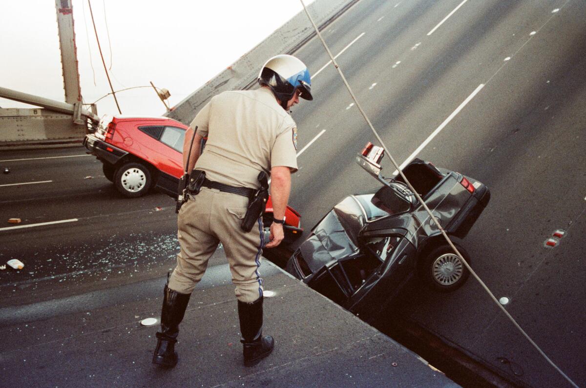
The so-called HayWired scenario envisions a scale of disaster not seen in modern California history — 2,500 people needing rescue from collapsed buildings and 22,000 being trapped in elevators, Hudnut said. More than 400,000 people could be displaced from their homes, and some East Bay residents may lose access to clean water for as long as six months.
The earthquake would cause 8,000 structures to collapse, 100,000 to be red-tagged — meaning they’re too damaged to enter — and 390,000 to be yellow-tagged, meaning occupancy is limited due to significant damage, Keith Porter, a University of Colorado Boulder research professor who coordinated the HayWired report’s engineering section, has said.
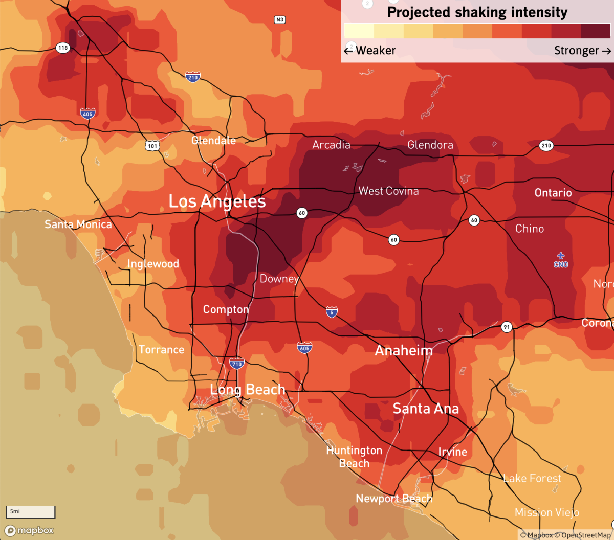
The U.S. Geological Survey published a hypothetical scenario of what a magnitude 7.8 earthquake on the San Andreas fault would look like. The ShakeOut scenario could result in the deaths of about 1,800 people.
More than 900 people could die from fire; more than 400 from the collapse of vulnerable steel-frame buildings; more than 250 from other building damage; and more than 150 from transportation accidents, such as car crashes due to stoplights being out or broken bridges.
Los Angeles County could suffer the highest death toll, more than 1,000, followed by Orange County, with more than 350 dead. San Bernardino County could have more than 250 dead and Riverside County more than 70 dead. Nearly 50,000 could be injured.
Main freeways to Las Vegas and Phoenix that cross the San Andreas fault would be destroyed in this scenario; Interstate 10 crosses the fault in a dozen spots, and Interstate 15 would see the roadway sliced where it crosses the fault, with one part of the roadway shifted from the other by 15 feet, seismologist Lucy Jones, an author of the report, has said.
The aqueducts that bring in 88% of Los Angeles’ water supply and cross the San Andreas fault all could be damaged or destroyed, Jones said.
A big threat to life would be collapsed buildings.
As many as 900 unretrofitted brick buildings close to the fault could come tumbling down on occupants, pedestrians on sidewalks and even roads, crushing cars and buses in the middle of the street. Fifty brittle concrete buildings housing 7,500 people could completely or partially collapse. Five high-rise steel buildings — of a type known to be seismically vulnerable — holding 5,000 people could completely collapse. From 500,000 to 1 million people could be displaced from their homes.
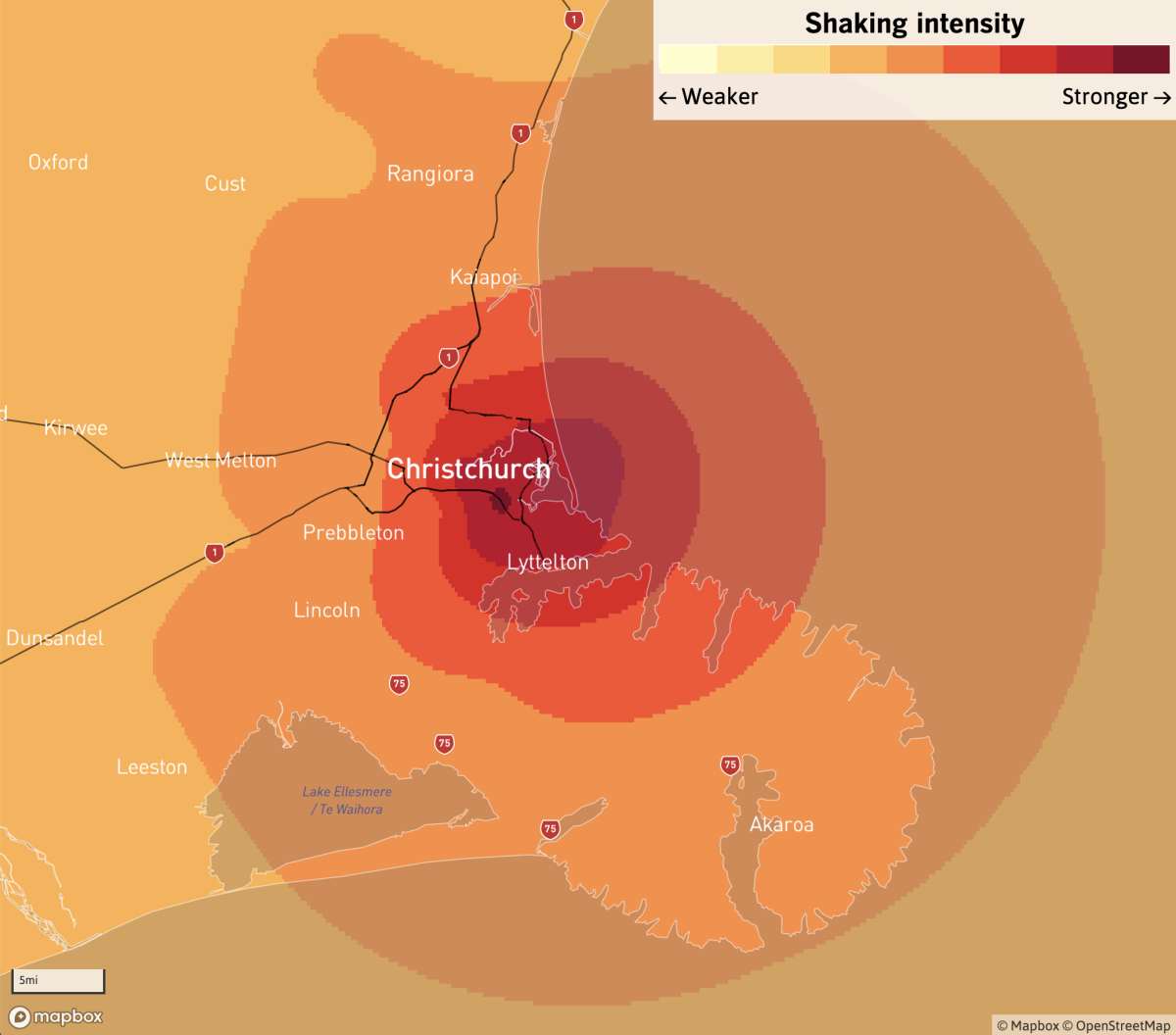
A magnitude 6.2 earthquake that hit New Zealand on Feb. 22, 2011, resulted in the deaths of 185 people. Many died in the collapse of just two downtown concrete office buildings, the six-story Canterbury Television building, killing 115 people, and the five-story Pyne Gould Corp. building, causing 18 deaths.
Two others came close to catastrophe: the 27-story Hotel Grand Chancellor nearly collapsed; at the Forsyth Barr Building, 18 stories high, many occupants became trapped when both sets of stairways collapsed.
More than 40 people were killed from older unreinforced masonry or brick buildings or block structures. The vast majority of them had been outside of the collapsing structures, including pedestrians and those riding by in vehicles.
So many buildings came tumbling down that Christchurch’s city center was cordoned off to the public, some areas for more than two years.
The quake redrew the geography of Christchurch. Downtown is now flatter and smaller, with 1,500 buildings in the Central Business District having been demolished. Some businesses left for the suburbs and never came back. Officials also bought and demolished 8,000 houses along rivers, the coast and in the hills and restricted those areas from future development.
Christchurch’s closest port, Lyttelton — New Zealand’s third-largest — suffered massive devastation, incurring more than $320 million in damage so extensive that the rebuilding process was expected to take at least 12 to 15 years. A big blow to Christchurch was that Lyttelton’s damaged wharves no longer allowed large cruise ships to dock. Large cruise ships are expected to return to Lyttelton next year.
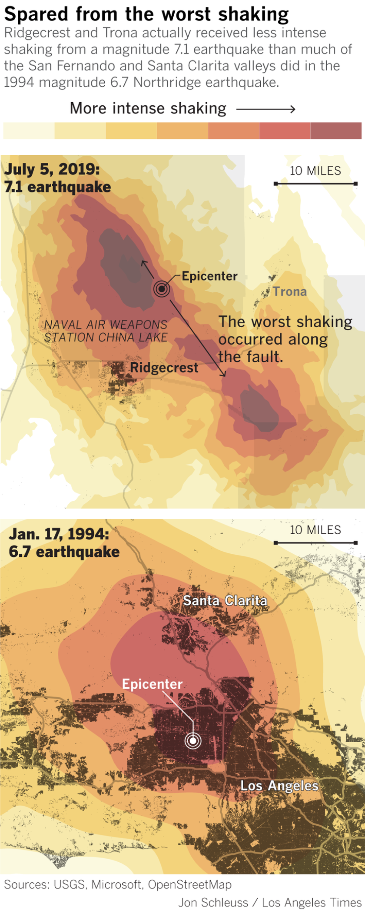
The magnitude 7.1 earthquake that hit near Ridgecrest on July 5 was the strongest to strike California in two decades.
The earthquake caused an estimated $5 billion in damage to Naval Air Weapons Station China Lake, the U.S. Navy’s largest base for developing and testing weapons of warfare, located in the Mojave Desert. An official told the Navy Times in August that more than half of the base’s damaged buildings were built before 1980 and did not meet seismic standards.
The nearby town of Ridgecrest, overall, suffered relatively little damage. The town, which began growing up near the Navy base during World War II, does not have a stock of unretrofitted brick buildings like those constructed before the 1933 Long Beach earthquake, USGS seismologist Susan Hough has said. There are also very few “soft-story” apartments with weak ground floors built to accommodate parking.
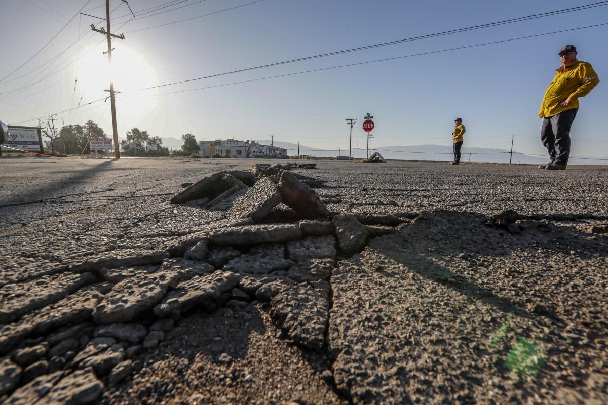
While mobile homes were torn off foundations, chimneys fell, gas lines leaked and some homes caught fire, many buildings did fine — and many businesses were up and running within a day or two of the biggest shock. The local newspaper said the Ridgecrest Cinemas, which suffered a roof collapse in one theater during the July 5 earthquake, reopened most of its screens later that month.
Trona, an unincorporated town southwest of Death Valley with a population under 2,000, appeared to have been hit harder than Ridgecrest. More than 30 homes were red-tagged as uninhabitable in Trona and other San Bernardino County communities. In the days after the earthquakes, there was no running water, electricity was unstable, and many residents resorted to sleeping in their cars or yards.
The magnitude 6.7 earthquake killed at least 57 people and left more than 80,000 residential and commercial units damaged or destroyed, as well as more than 5,000 mobile homes. Some 125,000 people were temporarily homeless after the earthquake.
The worst shaking was felt in a small section of L.A. County, with most damage in the San Fernando Valley. Wide swaths of the county did not suffer major damage.
The earthquake delivered its worst shaking to relatively newer buildings in the San Fernando and Santa Clarita valleys, recorded as “severe” shaking on the Modified Mercalli Intensity Scale, a strength that can damage poorly built structures.
Two concrete buildings collapsed catastrophically: a Bullock’s department store and a Kaiser Permanente medical office in the San Fernando Valley. Hundreds could have died had the earthquake occurred during the workday, and not at 4:31 a.m.
The shaking nearly caused a new steel-frame Automobile Club of Southern California building in Santa Clarita to collapse. A total of about 200 steel-frame buildings had significant cracking, raising questions about the safety of such structures in a severe earthquake.
The shaking also seriously damaged or destroyed 200 wood-frame apartment buildings with flimsy ground stories, known as “soft-story” buildings. One that catastrophically collapsed on its ground floor killed 16 people, most of whom were sleeping.
In 2015, L.A. officials passed laws requiring retrofit of soft-story and brittle concrete buildings. There is no L.A. retrofit law for steel-frame buildings, although two nearby cities, Santa Monica and West Hollywood, do have that requirement.
The Northridge earthquake caused $20 billion in damage and $49 billion in economic losses.
Start your day right
Sign up for Essential California for news, features and recommendations from the L.A. Times and beyond in your inbox six days a week.
You may occasionally receive promotional content from the Los Angeles Times.