California and the West can see small glimmers of hope in weather outlooks for October

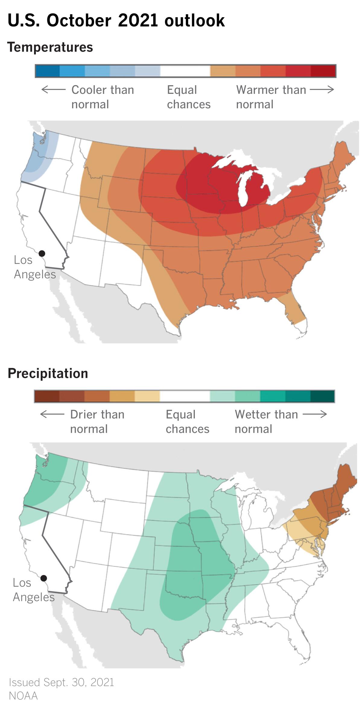
Outlook maps for October temperature and precipitation in the U.S. offer a glimmer of hope for California and parts of the West. For the first time in months, California’s precipitation outlook map isn’t colored a desiccated brown, indicating drier-than-normal conditions.
Likewise, the temperature outlook map isn’t glowing red, resembling a stove-top burner set on high.
On both maps for October, issued on Sept. 30 by the National Oceanic and Atmospheric Administration, California and neighboring states are colored a neutral white. That means experts predict equal chances that temperatures and precipitation will be above average, near average or below average.

If that sounds a little like cold comfort, remember that maps for months have placed California and the West in the hotter- and drier-than-average categories. So this is an improvement.
Normal rainfall for October in downtown Los Angeles is 0.58 of an inch. The NOAA Climate Prediction Center’s outlook means that the odds of a much wetter-than-average month are as good or better than the odds of a much drier-than-average month. The maps show the probability, or percent chance, based on the climatological record from 1991 to 2020.
October is not a rainy month in Los Angeles. The wettest months in Southern California are December, January and February.
The last regionwide storms dropped 1.41 inches of rain on downtown Los Angeles in early March, climatologist Bill Patzert said. Since March 15, downtown has gotten about a half-inch from spotty monsoon showers, but Southern California has seen no regional rain for almost seven months.
“Any change in the atmospheric pattern that has us locked in this drought would be welcome,” Patzert said. The system expected to arrive on Friday will be the first north Pacific front since March, he said.
Washington, most of Oregon and northern Idaho are depicted in NOAA’s outlook map as wetter than normal. And some of that wetter-than-normal green extends south into drought-stricken Northern California.
This map predicts that a broad swath in the middle of the country from North Dakota to Wisconsin and south to New Mexico, Texas and Louisiana will be wetter than average. This month, the map’s brown is in the the Northeast and New England, which are predicted to be drier than normal in October.
In the temperature outlook, the U.S. east of the Rockies will be warmer than normal, while coastal Washington and Oregon are expected to be cooler than normal. During October, California, Nevada and Arizona are expected to have equal chances of being warmer than average, average, or cooler than average.

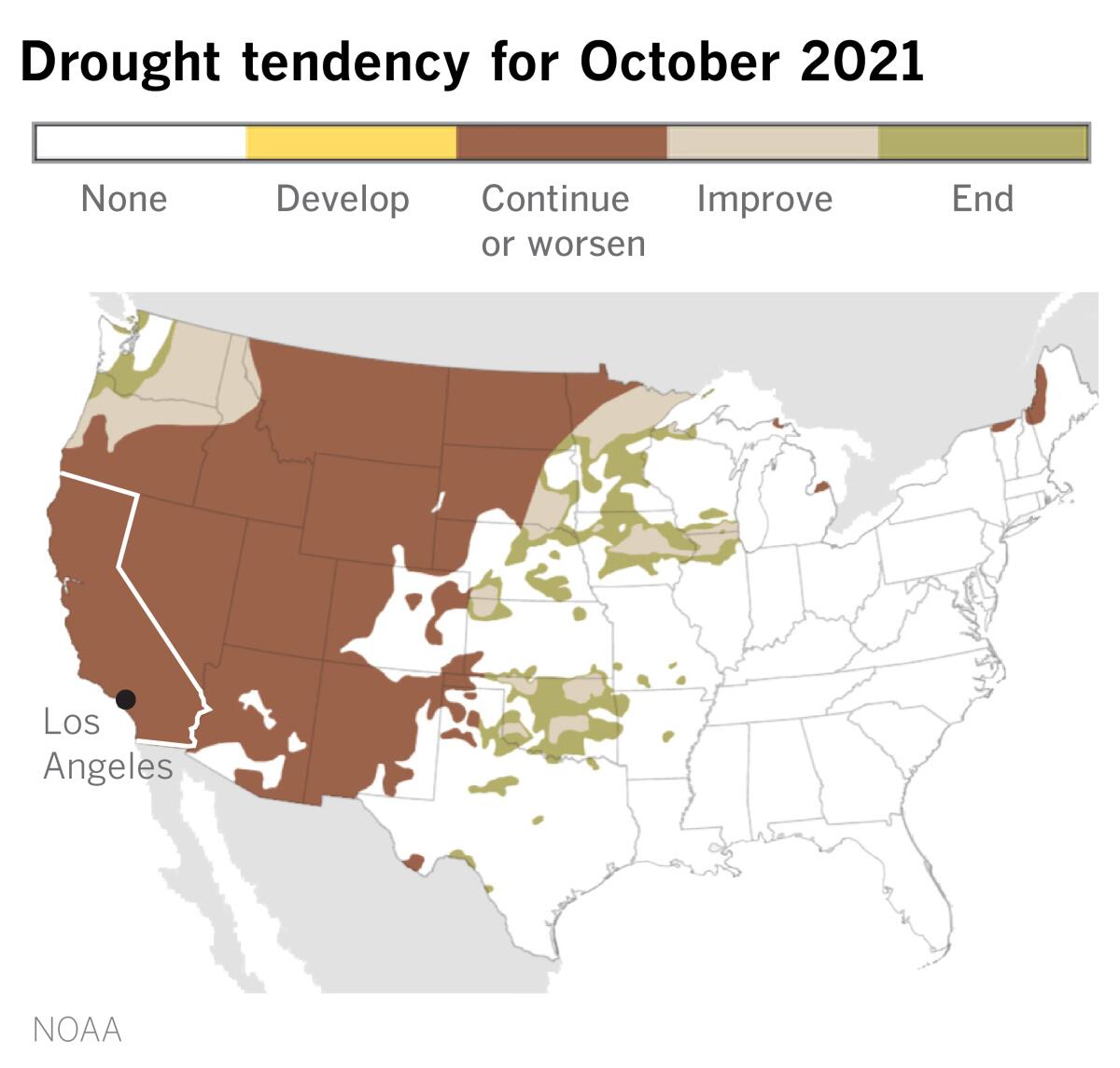
If the temperature and precipitation outlooks offer some slightly positive news, the drought map is the Debbie Downer of the forecast maps. A large portion of the West is colored brown, indicating that drought will continue or worsen. But a closer look shows a few hopeful signs around the edges. The drought is expected to end or improve in Washington and parts of Oregon and Idaho, as well as in parts of the upper Midwest and Great Plains.
Droughts of this magnitude take a long time to develop, and they wouldn’t be likely to disappear in the period of one month, so this isn’t particularly surprising.
A wild card in all this is the fact that October is a peak month for typhoons in the western Pacific. Tropical cyclones on the far side of the ocean from California can travel to the north or northeast, where they may influence the jet stream.
The jet stream, also called the storm track, is a narrow band of strong winds rushing from west to east in the upper levels of the atmosphere. Powerful storms such as typhoons can muscle the jet stream’s patterns of low-pressure troughs and high-pressure ridges, a little like battle rope waves, and these changes can affect the West Coast of North America.
So storms on the other side of the world can add an element of uncertainty to temperature and precipitation forecasts for California, especially in October.
After months of being on a continuous loop of heat, drought and wildfire, Californians can hardly be blamed for finding some slight encouragement in the NOAA outlook for October.
More to Read
Start your day right
Sign up for Essential California for news, features and recommendations from the L.A. Times and beyond in your inbox six days a week.
You may occasionally receive promotional content from the Los Angeles Times.


