Hurricane Arthur heads north, out to sea after hitting North Carolina
North Carolina’s Outer Banks absorbed a direct hit from Hurricane Arthur on Friday but emerged with only minimal damage as the storm blew out to sea and threatened riptides and flooding from New Jersey to Massachusetts.
“I think we dodged one,” Mike Sprayberry, North Carolina’s emergency management director, said Friday morning.
------------
FOR THE RECORD
An earlier version of this post misspelled the first name of Sheriff’s Capt. Kathryn Bryan.
------------
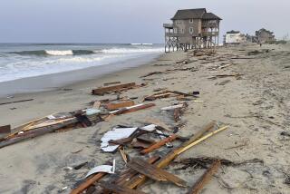
The first named hurricane of the Atlantic season brought flooding, beach erosion and power outages to the North Carolina coast. But no deaths or serious injuries were reported, and thousands of tourists made plans to resume July 4 weekend celebrations as sunshine returned.
“Things look quite good -- there has been minimal damage,” North Carolina Gov. Pat McCrory told reporters at a mid-morning news conference.
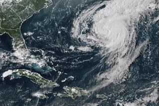
Arthur pushed out to the open Atlantic late Friday afternoon. The National Weather Service posted tropical storm warnings for Nantucket, Cape Cod, Nova Scotia, Prince Edward Island and New Brunswick. The weather bulletin warned of “large and damaging waves” and “life-threatening rip currents.”
The hurricane was 170 miles southwest of Chatham, Mass., at 5 p.m. EDT, moving at 26 mph, the weather service reported. Maximum sustained winds dropped to 80 mph, reducing Arthur to a Category 1 hurricane. The storm made landfall as a Category 2 hurricane at 11:15 p.m. EDT on Thursday near Cape Lookout, N.C., with maximum sustained winds of 100 mph.
The worst flooding hit the isolated Outer Banks barrier islands of Hatteras and Ocracoke, where roads were cut by overwash and power was knocked out. On Roanoke Island just west of the Outer Banks, the historic downtown area of Manteo was flooded after Arthur’s counterclockwise winds blew floodwaters from Pamlico Sound.
Six to 8 inches of water flooded storefronts in Manteo and power was out in some parts of town, said former Mayor John Wilson. He said the eye of the storm passed over the island around 4 a.m.
“The water’s already starting to go down -- I think we’ll be able to go out and start cleaning up in a couple hours,” Wilson said Friday morning.
About 44,000 customers lost power in North Carolina, McCrory said, and some inland highways in the eastern part of the state were flooded.
On the Outer Banks, the fragile Bonner Bridge remained closed as officials waited for floodwaters to recede so that they could assess the structure’s stability. The bridge provides the only road access to Hatteras Island, where narrow Highway 12 was flooded and blocked by overwash.
McCrory said crews hoped to reopen the road and bridge by Saturday afternoon.
In Kill Devil Hills on the northern Outer Banks, a large residential neighborhood was flooded and some roads were under water, said Capt. Kathryn Bryan of the Dare County Sheriff’s Department.
“But overall, we fared better than expected,” Bryan said.
On most of the Outer Banks, beachgoers slowly returned to the sand Friday, walking across eroded beachfronts amid floating debris. An estimated 250,000 people were staying on the 200-mile-long barrier islands for the holiday weekend, although some left Thursday as the storm approached.
It was the earliest hurricane to hit North Carolina since records began in 1851, according to the National Weather Service. The previous record was July 11, 1901.
In Boston, the annual Boston Pops Fourth of July concert and fireworks show were moved up a day to Thursday, just beating a downpour from Arthur. Fireworks displays were canceled or postponed in several coastal areas in the Northeast.
In North Carolina, McCrory planned to attend a July 4 parade in the coastal town of Southport on Friday. “The North Carolina beaches are open for business,” he said.
Follow @DavidZucchino for national news
More to Read
Sign up for Essential California
The most important California stories and recommendations in your inbox every morning.
You may occasionally receive promotional content from the Los Angeles Times.
