Indonesia’s Paluweh volcano from space: Green blob, plumes of ash
What does a volcano look like from 438 miles above the Earth’s surface? Thanks to NASA and its new Landsat Data Continuity Mission satellite (LDCM), you can see for yourself.
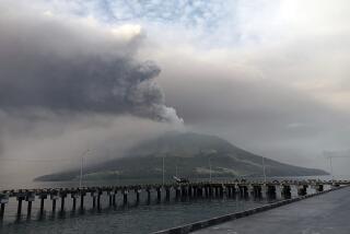
On April 29, the satellite captured two images of the Paluweh volcano spewing a plume of smoke that drifted for miles off the 5-mile wide volcanic island. The volcano, which looks like a wrinkly green blob from space, sits in Indonesia’s Flores Sea.
The satellite actually sent two images of the volcano using different imaging techniques.
At first glance, it’s the color image taken with the satellite’s Operational Land Imager that seems more exciting. The green of the island is a pretty contrast to the dark blue of the water, and right at the top of the island you can see where the smoke from the volcano is dense and thick.
But scientists are geeking out over the gray tone image that was created by the satellite’s Thermal Infrared Sensor (TIRS) because of its ability to so accurately capture the boundaries between the hot lava, which is rendered bright white on the image, and the cooler ash clouds, which look almost black.
The sensor instrument is so sensitive, that it can pick up tiny shifts in temperature, NASA explains. That’s especially impressive because taking the Earth’s temperature from space is not easy--the planet’s atmosphere usually gets in the way and changes thermal signals.
Engineers solved the atmosphere-interference problem by giving the satellite’s Thermal Infrared Sensor two thermal bands that react to the interference slightly differently. By taking measurements from both, and then measuring the difference, scientists say they can get a better sense of the real temperature at the Earth’s surface.
The Landsat Data Continuity Mission satellite launched earlier this year, and is the eighth satellite in the Landsat series, which started collecting information about the Earth in 1972. The satellite circles the Earth about 14 times a day, and returns to each location on Earth every 16 days.
It is still going through some testing and calibrating, but should be fully operational by the end of May when it will be handed over to the U.S. Geological Survey, which will help make all of the information it collects free on the Internet almost in real time. The goal is to make the images publicly available just 48 hours after they are captured.


