Column: Imagine if the 2 Freeway ended in a brilliantly colored, eco-smart park
There are two ways you can look at the long spur of the 2 Freeway as it runs south from the 5 Freeway and descends into Silver Lake and Echo Park.
You can see it as the abandoned beginning of a long-planned connection between the 5 and the 101, shaking your fist at the frustrating gaps that remain in the L.A. freeway network.
Or you can argue that because Los Angeles is simply no longer in the freeway-building business — meaning that gap is virtually certain never to be filled — the mile-long stretch of road is better understood as the potential platform for a new kind of green space in a park-starved city.
As I made clear last year, in a series of articles on reimagining the L.A. freeway for the 21st century, I am firmly in the second camp.
So is Chris Reed, a landscape architect and associate professor at Harvard’s Graduate School of Design. With his firm, Stoss Landscape Urbanism, he has taken my suggestion about the freeway stub and run with it.
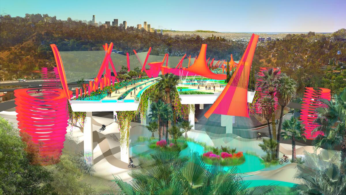
The park would be dotted with towers designed to clean the air and capture solar energy and storm water.
Or maybe it’s more appropriate to say he’s watched over the seed I planted and coaxed it into something with a life of its own. His proposal for turning that part of the freeway into an elevated park is a sort of fantasia — in shades of orange and fuchsia — on the classic Los Angeles themes of water, sunshine and the infrastructural sublime.
Closing the spur to traffic but preserving the elevated structure itself, the park would be dotted with towers designed to clean the air and capture solar energy and storm water.
Some of that water would be used to irrigate new planted areas; on very hot days, huge cooling towers would be switched on to convert a modest amount of water to mist.
THE FREEWAY REIMAGINED: Michael Maltzan’s proposal for the 134 near Pasadena »
Giant shade structures would be wrapped in a photovoltaic skin, generating enough power to operate smog filters designed to suck in and clean polluted air.
The surface of the old freeway (the “State Route 2 Terminus,” to use the official Caltrans language) would be covered with carbon-absorbing paving capable of trapping pollutants from the air while allowing storm water to pass through and flow to ground-level retention ponds.
The area beneath the structure would also be opened to the public, holding both an adventure park in the shadow of the old freeway and walking and bike paths leading to nearby Elysian Park and the Los Angeles River.
There is also an easy possible connection from the remade spur to the 10-acre Corralitas Red Car property, which may soon become a park thanks to efforts by local activists and the Trust for Public Land.
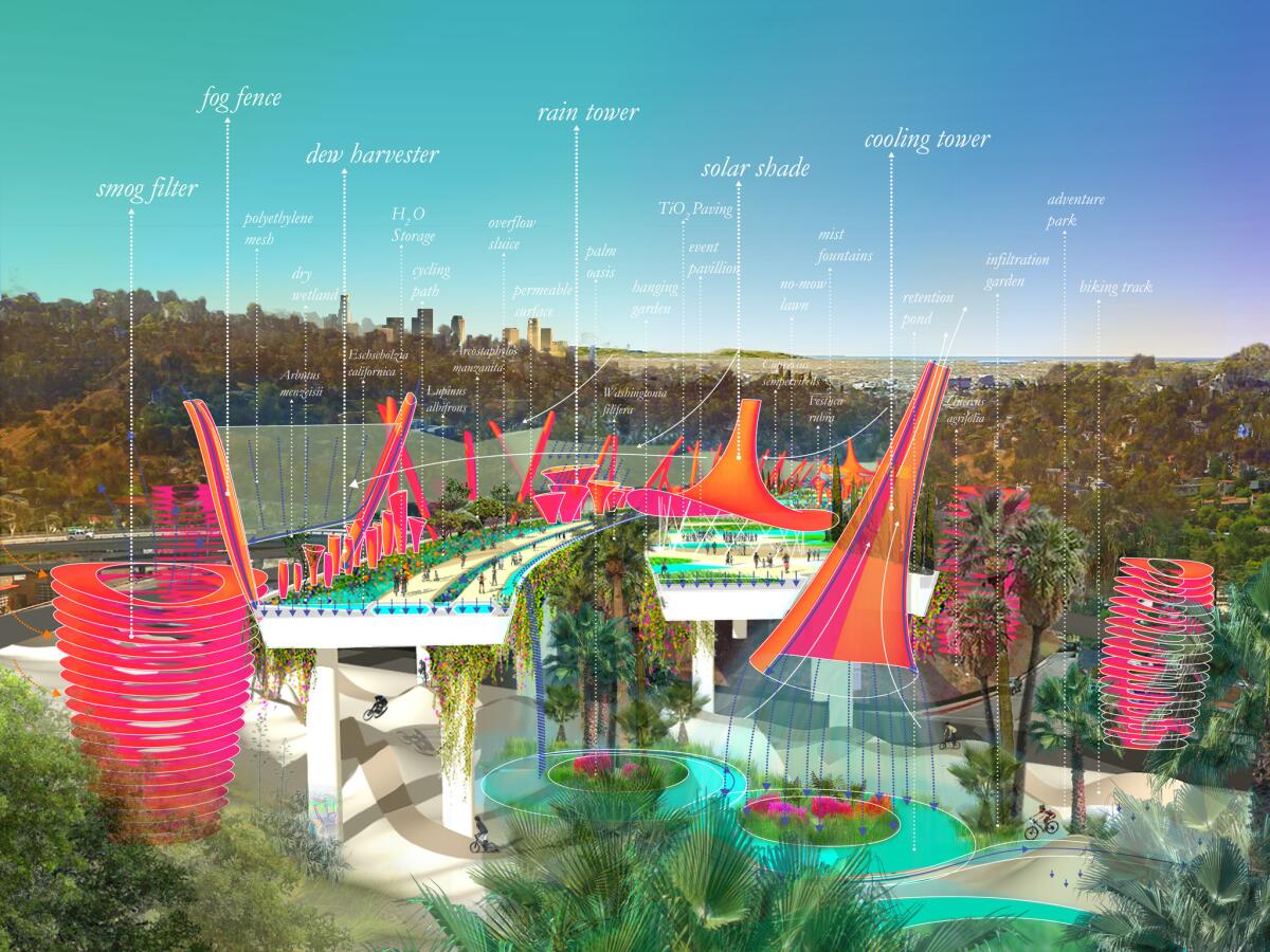
As Reed points out, the proposal contains ideas that could help remake other freeway spurs, including the stretch of the Marina Freeway that runs near Loyola Marymount and crosses Ballona Creek.
The end of the 2, he writes in a description of the design, “is ripe for rethinking in ways that might serve as an incremental model for similar freeway stubs in the region, and eventually for longer portions of freeway. Our proposal does so without pretending it away — like many others, we acknowledge the appeal and heroism of these infrastructural monuments — but by remaking the freeway as a social connector, a smog and carbon absorber, an important piece of sustainable hydrologic infrastructure and a catalyst for civic and recreational activities.”
Residents would benefit in all sorts of ways from this reimagination of the freeway.
As for the cars that now use this section of the freeway, which is essentially a very long off-ramp, Reed suggests rerouting some of them from the 5 Freeway interchange along Alessandro Street, which runs roughly parallel to the freeway spur’s eastern edge and in his proposal is remade as a formal boulevard. Cars continuing south would then make their way to Glendale Boulevard, which sits at the base of the freeway spur and has long absorbed the brunt of its traffic.
Before the residents of Alessandro Street decide to march on the offices of the L.A. Times, it’s worth pointing out a couple of things.
One is that other cities, including San Francisco and Seoul, South Korea, have removed stretches of freeway that once carried far more traffic than the stub end of the 2 — and have lived not only to tell the tale but to wonder why they didn’t make the change earlier.
(In a larger sense, a city that makes its land-use and open-space decisions solely on the basis of anxieties about traffic is a city that will find itself — much like contemporary Los Angeles! — both drastically short on parks and facing sky-high housing prices.)
The other thing to point out is that those residents would benefit in all sorts of ways from this reimagination of the freeway that now runs above their heads. Even if they’d see more traffic on Alessandro itself, living along a landscaped formal boulevard adjacent to a major new park is far more desirable — and far better for their property values — than living next to a roaring highway.
In fact, one great promise of the proposal is what it would mean for economic development in this part of Los Angeles. Pieces of land that have been noisy and polluted would suddenly overlook a quiet green space. There is no doubt they would become immediately more desirable in social, urban and economic terms.
This in turn suggests the potential for the proposal to pay for itself — either with a special tax on increased property values or the sale of a small number of publicly owned parcels alongside or even under the elevated freeway.
Instead of connecting us to each other, in some ways our highways have represented a separation.
— Anthony Foxx, President Obama’s Transportation secretary
Residents of Echo Park and Silver Lake have been debating the future of this stretch of the 2 and of Glendale Boulevard with city officials, Caltrans and the Metropolitan Transportation Authority for many years. Community meetings begat studies, which led to more meetings.
Eventually the groups settled on some improvements to the Glendale Boulevard median, a sound wall and other modest changes. A second phase of more significant upgrades remains in limbo.
It’s clear we need a bigger and bolder plan to break this essentially bureaucratic impasse.
The Stoss proposal, though not meant to be a final design by any means, is certainly that. It also connects L.A. to an expanding conversation about the future of urban highways across the country.
In recent months, notably, this conversation has been led from the top, by Anthony Foxx, President Obama’s Transportation secretary since 2013. In March, Foxx gave a speech at the Center for American Progress in Washington setting out in unusually blunt terms the price many urban neighborhoods paid for the construction of the U.S. interstate highway system in the decades after World War II.
“Instead of connecting us to each other, in some ways our highways have represented a separation,” he said, adding that the freeways rammed through parts of Charlotte, N.C., where he grew up and later served as mayor, were responsible for “destroying the connective tissue” that had long held those neighborhoods together.
“The corner store was gone,” he said, “because the corner was gone.”
He added that decisions about where to build urban freeways were inextricably linked to issues of race and class.
“Decision makers really thought of low-income and minority communities as in many ways the communities of least resistance,” he said.
Foxx’s remarks suggested how dramatically the federal government’s attitude about highway construction has shifted in recent years. No longer does Washington blithely or aggressively subsidize the construction of freeways through the center of American cities.
It’s not enough, though, to pursue a more enlightened kind of decision making when it comes to the placement of new freeways. We also have to grapple with the question of how to repair the damage done by the construction of existing ones.
We need to start talking, to borrow Secretary Foxx’s metaphor, about how to replace both the corners and the corner stores demolished by freeways — how to bring back the sense of community, of full and shared publicness, that so much of our 20th century infrastructure managed to erase. And we need to do it even when it’s complicated or politically controversial.
christopher.hawthorne@latimes.com
ALSO
Frank Gehry’s controversial L.A. River plan gets cautious, low-key rollout
Drones see the world in a way human photographers can’t: See Dronestagram’s winning contest photos
Design team led by Mia Lehrer picked for new downtown L.A. park
Why the Expo Line to Santa Monica marks a rare kind of progress in American cities
More to Read
The biggest entertainment stories
Get our big stories about Hollywood, film, television, music, arts, culture and more right in your inbox as soon as they publish.
You may occasionally receive promotional content from the Los Angeles Times.
