Column: Transforming the end of the 2 Freeway could be the beginning of a new L.A.

- Share via
Around the country, cities are demolishing stretches of highway, turning them into parks or boulevards.
Los Angeles has an opportunity to do something even more dramatic: to close a piece of elevated freeway to traffic but keep it intact as a huge platform for new open space and housing.
In a single gesture, the city could produce significant parkland and a monument to the ambition that produced the Southern California highway network in the first place.
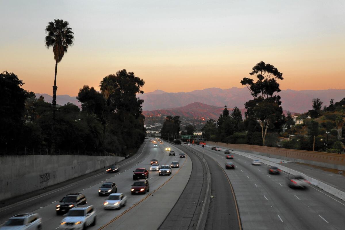
The stretch I have in mind is the stub end of the 2 Freeway as it bends south and west from Interstate 5 and dips into Silver Lake and Echo Park, two miles or so from downtown Los Angeles.
See more of Entertainment’s top stories on Facebook >>
Is this a freeway? A glorified offramp? In fact, it’s something of a hybrid, wide enough to match the 405 through the Sepulveda Pass but in practice a transitional and vastly overscaled road, slowing drivers as they leave the freeway and rejoin street traffic on Glendale Boulevard.
Though many of those motorists are too busy driving to notice, this stretch of the 2, about a mile long, also snakes through a remarkably beautiful natural landscape, a narrow valley with hills dotted with single-family houses on both sides.
Because we’ve been taught as Angelenos that every bit of freeway is not only desperately needed but also practically sacred, it’s tempting to look at this extra bit of the 2 on the map and think that it needs to be extended to connect with the 101 a mile or so south. (That was the original plan; community opposition in the early 1960s kept the freeway from being lengthened, leaving us with the abbreviated spur we know today.)
Considered on its own terms — as a part of a neighborhood rather than a huge transportation network, with local instead of regional potential — it begins to take on a different character.
Closed to traffic, the spur could be remade as an urban park at the stunning, nearly sublime scale of the freeway. It could be a bikeway (with remarkable views) connecting to paths along the nearby Los Angeles River. It could hold housing, schools, a giant urban farm or a large solar array. It could help capture and treat storm water.
In fact, it is large enough to be — and do — all of those things.
A freeway full of cars is among the noisiest, most polluted landscapes in the city. The land along it is among the least healthful and least desirable.
Transforming a freeway into parkland instantly turns all those liabilities into attractions. It transforms noise into quiet, gray into green, dangerous into healthful, a no man’s land into a destination.
There is no other single strategy available to urban planners capable of unleashing so much positive change so directly.
Think of the spur as being made up of three sections. The wide portion near the 5, too close to freeway traffic to be suitable for housing (at least until the promised era of electric, driverless cars arrives), could be ideal for solar arrays or storm water treatment.
The middle third could hold a mixture of park space and new housing. Apartments could also be built alongside or cantilevered out over the bed of the old freeway, rising from what is now Caltrans right-of-way.
The final section, where the 2 joins the street grid and connects to Glendale Boulevard, could become a sloping, south-facing park, dotted with urban farms or public art.
I know what many of you are thinking: What about traffic?
For the most part, when urban highways are decommissioned or rerouted, drivers adapt more quickly and easily than anticipated, keeping the feared traffic apocalypse at bay. This was true with San Francisco’s Embarcadero (taken down after the 1989 Loma Prieta earthquake) and freeways in other cities.
This plan — to redesign an elevated freeway as housing and public space rather than tear it down — is a slightly different animal. Traffic engineers would have to study the potential ripple effects on traffic in other parts of the city (just as they are now considering the effect of closing a section of the Terminal Island Freeway in Long Beach).
Drivers who use the 2 to get from the southern Glendale area to the 101 would have to find new routes. Other drivers would be inconvenienced as well.
Politically, pulling off this transformation would also be — well, complicated. Los Angeles would have to persuade the state to close the spur to traffic and either sell the land to the city or jointly redevelop it.
But dealing with those obstacles would be a small price to pay for the benefits the plan would deliver, particularly in terms of public health.
It could also operate as a model for efforts to re-imagine other underused freeway spurs around the region, including the sunken stretch of the Marina Freeway running west of the 405, near Ballona Creek.
An elevated park filling a retired stretch of freeway may sound reminiscent of the High Line, the hugely popular park built along an abandoned elevated train line in Manhattan.
In symbolic and practical terms, the potential of a remade 2 spur is greater than even that project. It would take a working stretch of freeway in Los Angeles, a city still synonymous with car culture, and reinvent it as a vibrant, diverse urban landscape. Instead of dividing Silver Lake from Echo Park, the elevated parkway (wide enough to dwarf the High Line) could reconnect the two neighborhoods.
If anything, the High Line offers not so much a model here as a cautionary tale. It has been so successful that it has produced a land rush along its length, creating a hyper-gentrified urban playground.
Transforming the tail end of the 2 Freeway would be closer in spirit to current efforts to remake the Los Angeles River. It would be an attempt to take the huge public-works infrastructure that shaped Los Angeles in the middle decades of the 20th century and redesign it for the 21st.
In an age of punishing, seemingly endless traffic, it’s easy to imagine that there is no slack in the Los Angeles freeway system, that every interchange is too narrow, every exit backed up.
There are more than a few places where engineers overbuilt or overextended that network, leaving hulking pieces of infrastructure ready to be transformed.
This is the great secret — and the great opportunity — of the contemporary L.A. freeway system. It is not merely the giant remnant of an old-fashioned, car-centric way of making cities. It has the potential to be the foundation for a new vision of Los Angeles urbanism, recreation, ecology, landscape architecture and mobility.
Twitter: @HawthorneLAT
MORE FROM CHRISTOPHER HAWTHORNE
Petersen Automotive Museum’s new look conveys a happily tasteless exterior
Here are better ideas for the land Caltrans has stockpiled for the 710 Freeway extension
Who will design Obama’s library? Key questions in architecture as 2015 wraps up
More to Read
The biggest entertainment stories
Get our big stories about Hollywood, film, television, music, arts, culture and more right in your inbox as soon as they publish.
You may occasionally receive promotional content from the Los Angeles Times.


