A Wet One’s Blowing Through
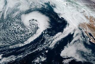
A violent Pacific storm finally marched onshore Monday, pelting parts of Southern California with wind-swept downpours that pushed rivers and creeks to the tops of their banks and threatened widespread mudslides and flooding.
Orange County, spared Monday, will probably get 1/4 to 3/4 inch of rain this morning, diminishing in the afternoon. “In some isolated areas it could be heavier,” said Byron Morton, a meteorologist with Weather Central, which provides forecasts for The Times.
Total rainfall for the season in Santa Ana through Monday was 12.66 inches, compared with 5.92 inches by this time last year. The average is 10.33 inches at this point in the season.
The National Weather Service issued a heavy-surf advisory through today, predicting breakers of 5 to 10 feet along most Orange County beaches.
“The combination of heavy surf, strong southerly winds . . . and the astronomical high tide Tuesday morning could cause minor tidal flooding and coastal erosion,” the advisory stated.
Forecasters said the storm had stalled off the coast for several days before launching its assault, picking up moisture from the sea that it hurled at the mountains and foothills ringing some of the Southland’s major cities.
The storm had dumped more than 13 inches of rain in the hills above the Santa Ynez Valley by nightfall Monday, and torrential runoff from slopes already saturated by earlier storms sent the Santa Ynez River and several tributaries surging above flood stage. Officials warned that homes in low-lying areas near Lompoc and Vandenberg Air Force Base were in danger of flooding.
The Ventura River near Ventura was rapidly approaching flood stage, prompting the evacuation of a riverfront mobile home park and threatening to close U.S. 101 near Oxnard.
By Monday afternoon, the core of the storm had begun moving into the Los Angeles area, where as much as 2 inches of rain was expected by this morning, with up to another inch by tonight. Flood warnings were issued through today in Los Angeles, Ventura, Santa Barbara and San Luis Obispo counties.
As much as 3 feet of snow was forecast in the Tehachapi, San Gabriel and San Bernardino mountains, which already had snowpacks up to 6 feet deep. The National Weather Service said winds up to 40 mph could whip up blizzard conditions and drop mountain visibility to near zero. Gusts twice that strong toppled vehicles on Interstate 5 near Gorman before dawn Monday, forcing closure of the state’s principal north-south highway for several hours.
Tim McClung, a weather service meteorologist, said the snow level would be relatively high: 6,000 to 7,000 feet. He said the heavy rain could cause significant snowmelt below that level.
*
Times staff writers Carol Chambers in the San Fernando Valley and David Kelly and Margaret Talev in Ventura County contributed to this story.
More to Read
Start your day right
Sign up for Essential California for news, features and recommendations from the L.A. Times and beyond in your inbox six days a week.
You may occasionally receive promotional content from the Los Angeles Times.


