Sunday and Monday will begin ‘a quick trip back to summer’ in L.A. region, forecasters say
Like some indestructible monster in a horror flick, summer-like heat in Southern California just keeps coming back.
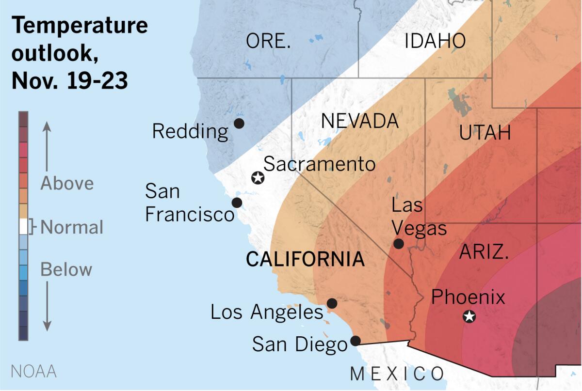
The National Oceanic and Atmospheric Administration’s temperature outlook for Nov. 19-23 favors above-normal temperatures in Southern California and the Southwest. The National Weather Service office in Oxnard tweeted, “Sorry fall lovers, we’re going to take a quick trip back to summer temporarily!”
The weather service predicts much warmer conditions on Sunday and Monday with gusty offshore winds. Gusts could be 20 to 40 mph Monday, the warmest day, with high temperatures between 82 and 92 degrees down to the beaches. The dry air will also result in elevated fire weather conditions, the weather service said.
August and September were the hottest on record, and preliminary data suggest that October 2020 will also go into the record books as the hottest October in the region, according to climate scientist Daniel Swain.
Arizona and California both experienced their warmest April-to-September period in 126 years, according to the U.S. Drought Monitor. This summer was also the most destructive wildfire season on record in California.
“After the cold temperatures of the last week, it might feel like a return to summer,” said Kathy Hoxsie, a meteorologist at the National Weather Service in Oxnard. “The above-normal temperatures will probably remind people of summer,” when temperatures were 10 to 15 degrees above normal. Some places will be 20 degrees above normal on Monday, she said.
Unlike summer, though, Hoxsie pointed out that nighttime temperatures will cool off. Sunday night will be in the low to mid-50s. She said that temperatures take a noticeable dip as soon as the sun sets at this time of year.
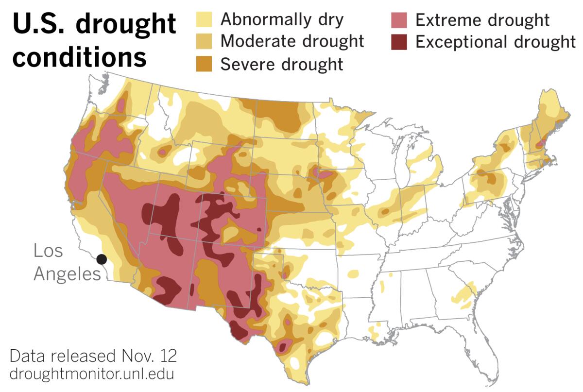
Although a Pacific storm brought significant and widespread precipitation to parts of the Northwest, conditions deteriorated in Northern California and in a broad swath from southwestern California through New Mexico, according to the latest data from the U.S. Drought Monitor released Thursday. Drought persisted or intensified throughout much of the Southwest and Four Corners.
Also Thursday, NOAA said that La Niña strengthened during October. Forecasters put the chances of La Niña lasting through the winter at 95%, and give it a 65% chance of persisting through the spring.
Although it’s early for clear La Niña impacts, NOAA said October did reveal some hints, including more rain in Indonesia, drier conditions in southeastern China and the U.S. Southwest, as well as cooler weather in Canada and the Northern Plains.
A La Niña occurs when the sea surface temperatures in the central and eastern equatorial Pacific are below average. Easterly winds over that region strengthen, and rainfall usually decreases over the central and eastern tropical Pacific and increases over the western Pacific, Indonesia and the Philippines.
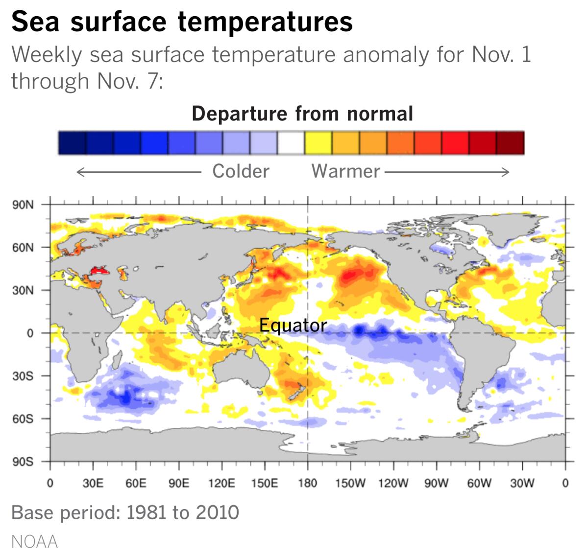
There are numerous global climate factors involved in predicting precipitation, but La Niñas are typically associated with colder, stormier-than-average conditions and increased precipitation across the northern parts of the United States, and warmer, drier and less stormy conditions in the southern portions of the country.
A La Niña is no guarantee of a dry winter, but La Niñas are statistically more likely to be dry than wet, Hoxsie said.
If that warm, dry scenario plays out, the summertime monster may continue to prowl the landscape, with all that portends for the expanding Western drought and the wildfire outlook in the remainder of 2020 and into 2021.
More to Read
Start your day right
Sign up for Essential California for news, features and recommendations from the L.A. Times and beyond in your inbox six days a week.
You may occasionally receive promotional content from the Los Angeles Times.


