La Niña may signal scant relief from California’s seemingly endless loop of hot, dry weather

- Share via
After a brief interlude of mild temperatures Saturday, a warm-up is forecast to begin Sunday as upper-level high pressure builds into California, the National Weather Service said. High temperatures will climb by several degrees on Sunday.
California just recorded its hottest September on record, according to the National Oceanic and Atmospheric Administration, and the state looks to be stuck in a nearly endless loop of hot, dry weather.
With a strong La Niña developing, the dry pattern is looking ever harder to break, and could be settling in to stay for a while. The forecast for the upcoming week is seasonably Santa Ana-ish, and does nothing to contradict that supposition.
Gusty winds are expected to develop below passes and canyons in the Santa Ynez Range of southern Santa Barbara County on Sunday night. North to northeast winds will also affect the Interstate 5 corridor and valleys of eastern Ventura County as well as northern and western L.A. County.
Dry, northerly winds will also arise in the San Francisco Bay area on Sunday, possibly growing stronger in the hills by midweek, raising potential fire weather concerns, the weather service said.
In Southern California, warm, dry conditions may be accompanied by weak Santa Ana winds Monday through Thursday, leading to elevated to locally critical fire weather conditions. Heat advisories may be issued for triple-digit temperatures in the inland valleys, and readings in the upper 80s closer to the coast Tuesday through Thursday.
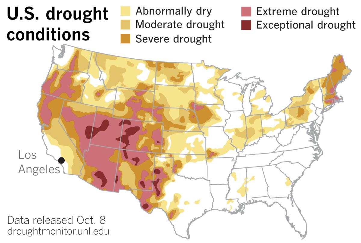
After the aforementioned respite, during which hoped-for rain didn’t materialize in Northern California, the theme of hot, dry conditions continues in California and the West, expanding the drought, according to the most recent U.S. Drought Monitor issued Thursday.
Arizona and California experienced their warmest April-to-September period in 126 years, the Drought Monitor reported. New Mexico and Nevada had their second-warmest such period. With the monsoon season essentially a no-show this year, Utah and Arizona recorded their driest period ever during that same six-month stretch. New Mexico had its second-driest and Colorado had its third-driest. Arizona’s newly established statewide precipitation record came in more than 2 inches drier that the previous record.
As a result of such infernal weather, areas of moderate, severe and extreme drought expanded in coverage throughout the West, according to the Drought Monitor.

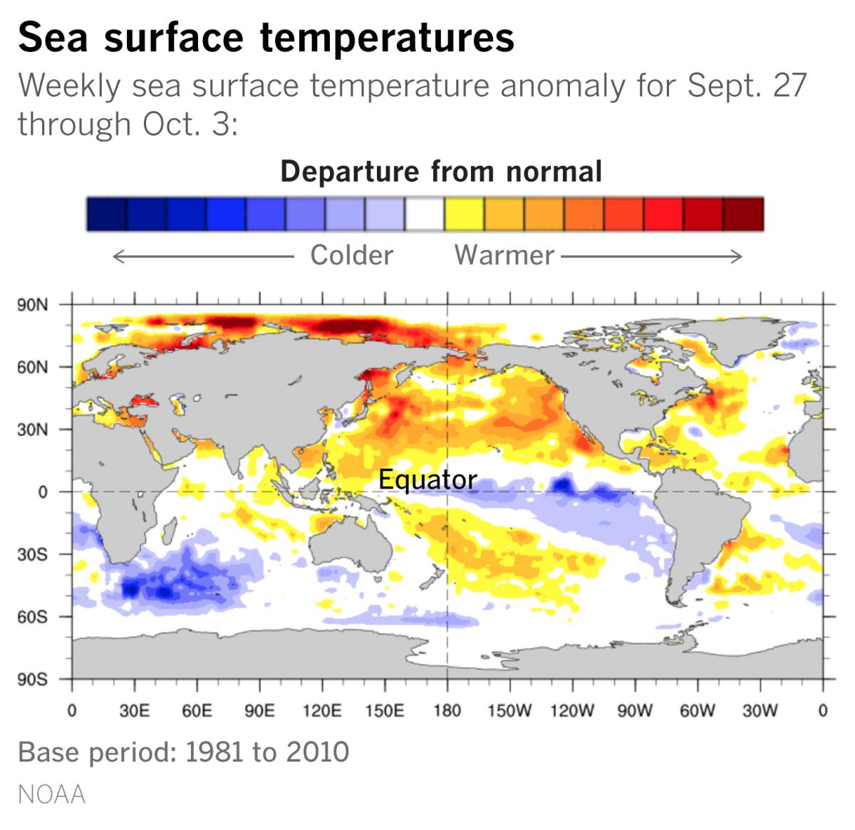
Meanwhile, NOAA said on Thursday that La Niña conditions in the tropical Pacific continue to develop, and forecasters now are expecting a stronger La Niña with about an 85% chance of it persisting through the winter.
A La Niña occurs when the sea surface temperatures in the central and eastern equatorial Pacific are below average. Easterly winds over that region strengthen, and rainfall usually decreases over the central and eastern tropical Pacific and increases over the western Pacific, Indonesia and the Philippines.
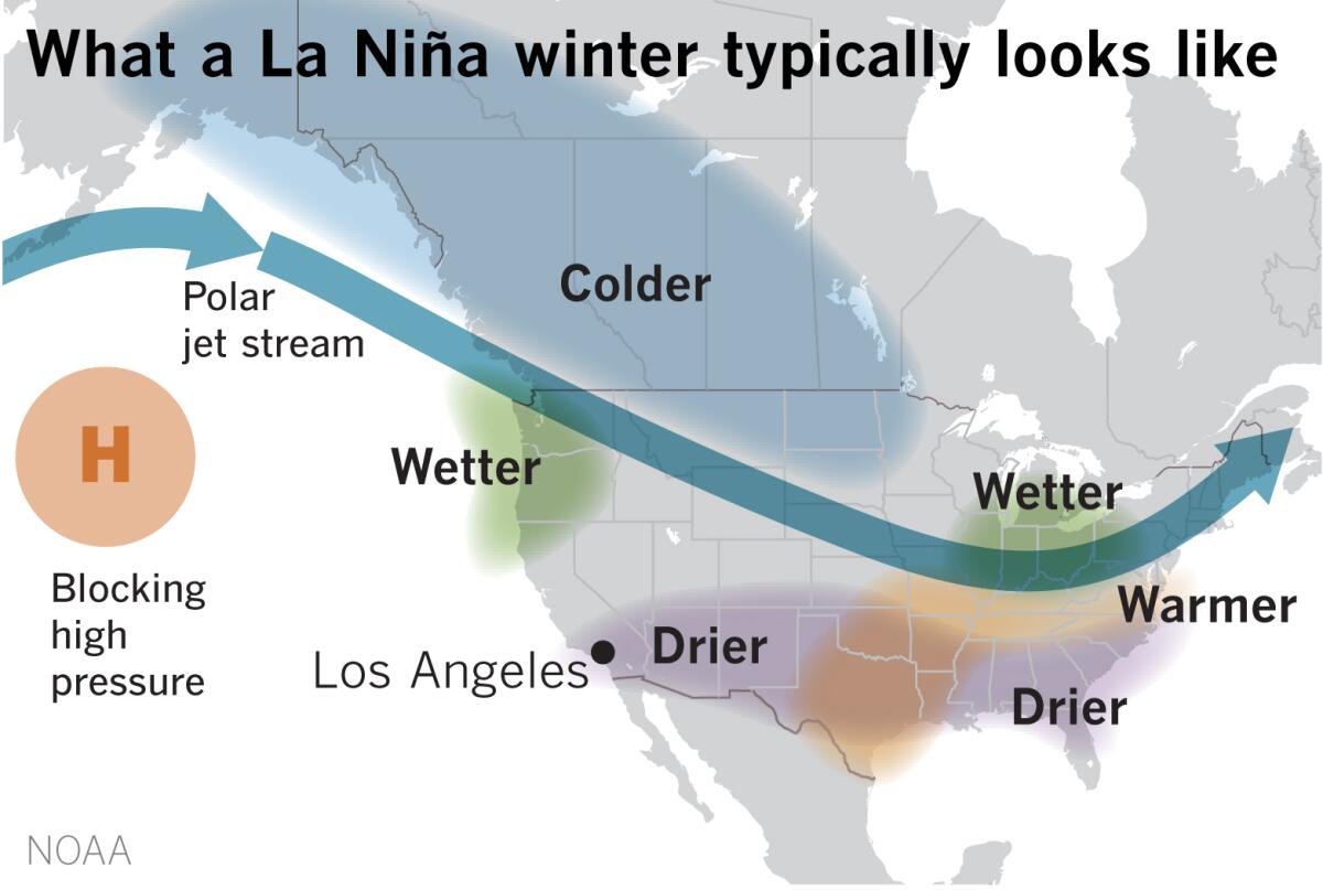
There are numerous global climate factors involved in predicting precipitation, but La Niñas are typically associated with colder, stormier-than-average conditions and increased precipitation across the northern parts of the United States, and warmer, drier and less stormy conditions in the southern portions of the country.
If this scenario unfolds, it would exacerbate drought conditions in Arizona, Colorado, Utah and California and worsen the wildfire outlook for the remainder of 2020 and into 2021.
California is already experiencing its worst fire season on record, surpassing 4 million acres burned — more than double the state’s previous record.

In addition, La Niñas usually weaken wind shear in the Caribbean and tropical Atlantic, contributing to increased hurricane activity in the Atlantic Basin. NOAA’s Climate Prediction Center factored the development of La Niña conditions into its prediction in August that an “extremely active” hurricane season was possible in the Atlantic. The Atlantic hurricane season runs from June 1 through Nov. 30, peaking from late August through the end of September.
NOAA’s outlook is being borne out as the 2020 season is turning out to be among the worst in history for Atlantic hurricanes.
“Looking at the damage from the hurricanes in the Gulf of Mexico, tornadoes and storms in the country’s midsection, and the fires and heat waves in the West, it has been a punishing and heart-breaking six months,” says climatologist Bill Patzert. “Weather forecasters across the county are sounding like the grim reaper these days.”
More to Read
Sign up for Essential California
The most important California stories and recommendations in your inbox every morning.
You may occasionally receive promotional content from the Los Angeles Times.


