Hazard Information for Would-Be Home Buyers
- Share via
Fires in the dry season, floods in the wet and earthquakes all year-round make California a perennial top contender in the category “place most inclined to natural disasters.” Although prospective homeowners may not be able to completely escape these devastating events, a state law originally set to go into effect March 1, and now postponed until June 1, guarantees that at least they will be better informed about the dangers they face before they sign on the dotted line.
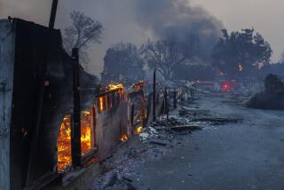
Starting in June, would-be home buyers will be presented with a single-page Natural Hazard Disclosure Statement notifying them if their prospective property lies within a 100-year flood plain or in a dam-inundation area; on or near an earthquake fault or within a seismic hazard zone; if it is particularly vulnerable to wild-land fires or, like the homes burned in the Malibu hills, lies within a “very high fire hazard severity zone.”
Included on the form will be a warning that the hazards may limit the owner’s ability to develop the property, get insurance or receive assistance after a disaster.
The law is a result of Assemblyman Tom Torlakson’s (D-Antioch) AB 6X, which was his response to the many complaints from homeowners caught in the floods of ’97. Many said they had no idea their homes were in potentially hazardous areas, even though existing federal law requires homeowners to purchase insurance if their property is located in a 100-year flood plain. The federal law also requires notification of wild-land fire danger and earthquake vulnerability at the time of purchase.
But at the time of purchase, home buyers are flooded with paperwork and may overlook the pro forma disclosures buried in the fine print of the many documents they must sign. Torlakson’s law is intended to highlight this crucial notification and make it more obvious. It also makes the seller legally responsible for disclosing fire danger and the Realtor or sales agent responsible for disclosing flood and/or earthquake danger.
However, when a number of Realtors sought to test the statute, they ran into a major glitch: There were few updated county maps available for identifying the range of hazards that must be disclosed under Torlakson’s proposal.
“People . . . got blank stares from county employees,” recalled Stan Wieg, a lobbyist with the California Assn. of Realtors. “The statute presumes the maps are there [in county offices] and that may be logical, but it’s not realistic.”
Realtors found that county employees were often unaware of the new requirements or unable to direct applicants to the correct office for the various maps required. The offices of local assessors, recorders and planning departments did not routinely post signs telling the public where maps could be found, a requirement predating Torlakson’s bill. And if maps were available, they might be scattered in offices from one end of a county to the other.
In order to give counties time to train employees, post notices and gather maps into convenient sites, Torlakson agreed to a three-month delay of the start date, originally March 1, for the requirements. County officials have agreed to post notices and put maps in central locations by June 1 so that Realtors and home sellers can fulfill the new statute.
But home buyers may still not have access to crucial data in several areas. Although the state’s Forestry Department mapped high-fire hazard zones in 1995 and sent them to all 58 counties, only 40% of local fire departments have matched the maps to specific addresses.
And the state just began issuing maps in 1997 delineating seismic hazard zones. Engineers at the Department of Mining and Geology have completed just 11 of 265 maps they say will pinpoint high-growth areas most vulnerable to quakes. So far, they’ve mapped the northern half of San Francisco and parts of Los Angeles, Orange and Ventura counties.
However, Los Angeles County, which has computerized geographical information systems already available, should within a year be able to match topographical maps against records of assessed property and identify most hazard-prone lots by parcel number and street address. But most other counties are far from this scenario.
“If everyone had their act together, they could generate a list of affected parcels, and we could print them out in local [real estate] offices,” said Wieg. “But we can’t do that yet.”
*
Please send comments or suggestions to annette.haddad@latimes.com
More to Read
Sign up for Essential California
The most important California stories and recommendations in your inbox every morning.
You may occasionally receive promotional content from the Los Angeles Times.


