Oregon Plumbs Depths of a Seafaring Mystery
- Share via
LINCOLN CITY, Ore. — There is something about a wrecked mystery ship that conjures spine-tingling images of high-seas drama, swashbucklers and pieces of eight.
But there was little of that in the Blanco, a two-masted square-rigger built for the coastal trade to help feed the voracious demand for lumber and other supplies in booming San Francisco and the California and Nevada mines.
The ship left San Francisco Nov. 6, 1864, headed for Coos Bay, Ore.
The next news came in the Oregon Statesman in Salem on Dec. 2, 1865.
“A large brig from San Francisco named Blanco was wrecked a few days since at the mouth of the Silets [sic] River,” wrote Indian agent Ben Simpson. “I have just returned from an examination of the vessel. She is a total wreck. Her masts are gone, her deck broken and her hull is split from deck to keel.”
So there she sat, and there she sits.
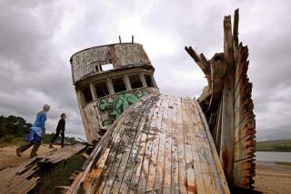
From time to time, although not for years, ships’ ribbing has poked through the shifting sands of Siletz Bay.
No one knows what happened to her crewmen. They could have been lost at sea, killed by Indians or met another fate.
At the time, local Indians said they knew nothing. But Simpson said they were in possession of kegs of nails, zinc sheeting, a calico dress, boots, gaiters and sail cloth.
Only some iron and rope rigging remained in the hull when Simpson found it.
There is no known Indian lore related to the shipwreck. Because of massive tribal relocations by the government in the mid-1800s, it is unlikely that the Siletz Indians living in the region today have many direct ties to those who lived on the coast nearly 140 years ago.
At the behest of Lincoln City, located on Oregon’s central coast, a team of scientists, amateur archeologists all, are hoping to find what’s left of the Blanco.
There have been shipwrecks by the hundreds along Oregon’s coastline over time but, by eliminating other candidates, researchers say it’s likely that the wooden ribs that occasionally tease the curious are those of the Blanco.
A boat builder surveyed what was visible of the wreck in 1951. From what he could determine, the dimensions were roughly those of the Blanco.
The 125-foot Blanco, built as a schooner in Coos Bay in 1859 or 1860 and refitted as a brig, never plundered the Spanish Main and probably had no gold beyond that in the teeth of her crew.
But tourist-conscious Lincoln City would like to put what’s left on display if it can be found.
A handful of local citizens gathered to watch on a recent Sunday as scientists, taking advantage of unusually low tides, and using old photos of the wreck and conflicting recollections of people who had seen it over time, tried to get an idea of where the ship’s remains lie.
Jon Cole, a professor of engineering and environmental science at Washington’s Walla Walla College, said the saltwater and sand likely would have helped preserve the wood.
Whether the ship actually is the Blanco, he said, may have to be determined by radio carbon dating and by other studies of the wood.
The scientists had hoped to use ground-penetrating radar to find the ship, but the possible area is too large.
In addition, they said, the saltwater and dense sand limit what their technology can do.
The project is a hobby for the scientists, who have worked on long-buried cities, walls and tombs in the Middle East and are volunteering their services. This is their first ship.
“We expect the ribs are close to the surface. Our technology doesn’t probe all that deeply,” said Gerald Sandness, a geophysicist with Battelle Pacific Northwest National Laboratory in Richland, Wash.
He said to use seismic gear they need a good idea of where the ship is. They had expected a fairly well-defined area but ended up with acres of possibilities.
“And we only have a few hours to work,” he said shortly before the tide started inching its way back into the bay.
Sandy Pfaff of Lincoln City’s visitor and convention bureau is seeking other photos of the ribs taken from different angles to help triangulate where the wreck lies.
But the sand-choked shallow bay, which was a working harbor decades ago, changes constantly. Houses on a bluff that are being used as reference points from early photos come and go.
“Because of the salt in the water, if we try ground-penetrating radar we’re pretty much sunk,” said Bradley Matson, a measurements engineer with Photon Kinetics in Beaverton, Ore. “We’ll evaluate our methods first. We’ll see how applicable our techniques are.”
The scientists took global positioning readings for future use and say that so far they aren’t sure what technology they will finally use to locate the wreck.
Permission would be needed from the Oregon State Parks Department if they tried to raise the Blanco, said Pfaff, since it would be classified as an archeological project.
It probably would involve a pricey coffer dam to protect the recovery effort.
“They didn’t need a permit to thump around on the sand because it’s not intrusive,” she said. “If it becomes intrusive, I’m not sure life will be as easy as it has been so far.”
“This could be a tough one,” Sandness said. “If we go to geophysics, we will have to do it at a later date.”
More to Read
Sign up for Essential California
The most important California stories and recommendations in your inbox every morning.
You may occasionally receive promotional content from the Los Angeles Times.


