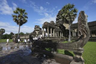
Angkor was a city ahead of its time
- Share via
The ancient Khmer city of Angkor in Cambodia was the largest preindustrial metropolis in the world, with a population near 1 million and an urban sprawl that stretched over an area similar to modern-day Los Angeles, researchers reported Monday.
The city’s spread over an area of more than 115 square miles was made possible by a sophisticated technology for managing and harvesting water for use during the dry season -- including diverting a major river through the heart of the city.
But that reliance on water led to the city’s collapse in the 1500s as overpopulation and deforestation filled the canals with sediment, overwhelming the city’s ability to maintain the system, according to the report in the Proceedings of the National Academy of Sciences.
The hydraulic system became “not manageable, no matter how many resources were thrown at it,” said archeologist Damian Evans of the University of Sydney in Australia, the lead author of the paper.
But during the six centuries that the city thrived, it was unparalleled, particularly because it was one of the very few civilizations that sprang up in a tropical setting, said archeologist Vernon L. Scarborough of the University of Cincinnati, who was not involved in the research.
Just one section of the city, called West Baray, was many times “larger than the entire 9-square-kilometer hillock on which sat Tikal, the largest city in Central America,” he said.
“The scale is truly unparalleled,” added archeologist William A. Saturno of Boston University, who also was not involved.
“Forest environments are not good ones for civilizations . . . because they require intensively manipulating the environment,” he said. “Angkor is the epitome of this, and it is going to be the model for how tropical civilizations are interpreted.”
Old and new technologies
The new data come from an unusual agglomeration of both old and new technologies. The core data came from a synthetic aperture radar unit flown on the space shuttle in 2000 and managed by NASA’s Jet Propulsion Laboratory in La Cañada Flintridge.
The radar pierced low-lying clouds and vegetation to give an accurate picture of soil density, local structures and moisture in soil, which reflects growing conditions.
The images revealed, for example, the characteristic moat-enclosed local temples and artificial ponds used for water storage and irrigation.
This information was supplemented with photographs taken from ultralight aircraft flown over the city at low speeds and altitudes.
Finally, the researchers used motor scooters to traverse the city and closely examine sites revealed on the radar images. But so many sites have been revealed, Evans said, that the researchers are only partway through this process.
The group, collectively called the Greater Angkor Project, released a partial map three years ago. The new one released Monday contains, among other things, an additional 386 square miles of urban area, at least 74 long-lost temples and more than 1,000 newly recognized artificial ponds.
Angkor was the capital of the Khmer Empire, which got its start in AD 802 when the god-king Jayavarman II declared the region’s independence from Java. At its height, the empire covered not only Cambodia but also parts of modern-day Laos, Thailand and Vietnam.
It is perhaps best known for Angkor Wat, the magnificent temple built by King Suryavarman II in the early 12th century.
Angkor has been studied for more than a century, but early scholars were so overwhelmed by the artworks and architecture, as well as the political successions, that they ignored the archeology, said coauthor Roland Fletcher of the University of Sydney.
In the late 1960s, French archeologist Bernard-Philippe Groslier began a more formal study of the ruins, but that work was halted for more than 20 years by the war that broke out in 1970.
After the war, archeologist Christophe Pottier of the Ecole Francaise d’Extreme-Orient in Siem Reap, another coauthor, renewed the work, beginning what eventually grew into the current project.
Disputes over history
In the process, the researchers have begun solving many of the disputes that have arisen over the city’s history, Evans said.
“The debate has always been . . . was it large enough, was the manipulation of the landscape intensive enough to cause environmental problems?” Evans said. “The answer is definitively yes.”
Other arguments have been based on the assumption that Khmer hydraulic engineering technology was rather rudimentary, he said. “What our research has shown is that it was extremely sophisticated and highly complex,” he said.
Many of the reservoirs and walls of canals were constructed of compacted earth, he said, but junctions and other crucial points in the system were “quite sophisticated stone structures.”
The Khmer built, for example, a massive stone structure to divert the Siem Reap River from its old bed through the center of the city. Other sites have stone structures built into the walls to manage the inflow and outflow of water, he said.
The system was complex enough that the Khmer could have grown rice throughout the year and not just during the rainy season, Evans said. It is not yet clear if they did so, however.
“The intentional movement of earth to create the whole water system is just really mind-boggling,” Saturno said. “It was an enormous undertaking” that required not just administrative skills, but also engineering know-how and massive amounts of physical labor.
But in the end, maintenance became too labor-intensive, Evans said. As trees were removed from the landscape, sediment began accumulating in the canals at a rate more rapid than it could be removed. Many dike walls collapsed, although it is not yet known when that occurred.
“We’re going now and excavating [the sites] on the ground, and trying to get a grip on when they happened -- whether they were a precursor of the decline, a symptom or the system gradually falling into ruin after they left,” he said.


