A Rainbow of History in East Mojave Desert
- Share via
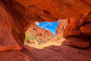
The designation on the map of “National Natural Landmark” is a tip-off, but nothing can prepare hikers for the colorful hills that make up Rainbow Basin. Pink, white, orange, brown, red, black and green sediments form the basin’s rainbow-colored walls.
Rainbow Basin is administered by the U.S. Bureau of Land Management, the agency in charge of the 1.5 million-acre East Mojave National Scenic Area. Rainbow Basin’s location just north of Interstate 15 in Barstow puts it just out of the scenic area (which will become a national park if Sen. Alan Cranston succeeds with his California Desert Conservation bill).
Though geographically gerrymandered out of the scenic area, Rainbow Basin is, to say the least, colorfully scenic. This place in the Calico Mountains is ideal for the hiker to sample the mountains, the geology and the rich historic record of the East Mojave Desert.
The topography of the Mojave, termed “basin and range,” is characterized by south-trending mountain ranges rising abruptly from the desert floor, separated by irregularly spaced basins. (Basins, unlike valleys, are not drained by rivers.) The mountains have been formed by the movement of land along earthquake faults that run through here.
About 15 million years ago, grasslands filled Rainbow Basin, then populated by saber-toothed tigers, mastodons, camels, three-toed horses and even rhinoceroses. Their fossil remains are encased in sedimentary rock that once formed a lake bed. As a result of intense geologic activity over the millennia, what was once at the bottom of the lake is now a series of folded, faulted, colorful hills.
Owl Canyon, one of three moderate hikes in Rainbow Basin, takes its name from the barn owls who live there. Hikers should be reasonably agile in order to tackle Owl Canyon Trail, because getting through the canyon means scrambling over some boulders.
You could spend a pleasant weekend camping and hiking in Rainbow Basin. Stationed at Owl Canyon Campground is a campground host, who can provide hiking and touring tips.
Directions to trail head: Follow Interstate 15 to Barstow, then join Highway 58 to Ft. Irwin Road, following it 5 miles. Turn west on dirt Fossil Road and proceed 3 miles to Owl Canyon Campground. The trail begins at the north end of the campground.
The Hike: Follow the marked trail into Owl Canyon. Half a mile up-canyon look for a small cave on your right. Sandstone and silt stone, shale and volcanic debris are among the exposed rock. The geologic formations en route are not only rainbow-colored but dramatic in shape. Particularly evident are massive down-folds geologists call synclines.
The canyon narrows for a time then opens up at its end into a multicolored amphitheater. Velvet Peak is the high spot above the rocky bowl. Experienced hikers can scramble up the bowl’s rocky ridges for fine views of Rainbow Basin and the vast East Mojave.
Return the same way.
For more information about Rainbow basin or nearby East Mojave National Scenic Area, visit the California Desert Information Center, 831 Barstow Road, Barstow, or call (619) 256-8617.
OWL CANYON TRAIL: Owl Canyon Campground to Velvet Peak; 5 miles round trip; 500-foot elevation gain.
More to Read
Sign up for The Wild
We’ll help you find the best places to hike, bike and run, as well as the perfect silent spots for meditation and yoga.
You may occasionally receive promotional content from the Los Angeles Times.


