Jewel in the Jungle
- Share via
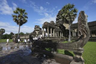
The jewel-like temple called Angkor Wat sits in the middle of 125 square miles of impenetrable Cambodian jungle. Although tourists brave the jungles to visit this shrine to Lord Vishnu, few know what exists under the forest canopy.
Even recent United Nations maps of the area outside the U.N.-protected archeological park read “God Only Knows.”
But not for much longer. New images made by an airborne radar system developed at JPL are allowing researchers to produce detailed topographical maps of the region. “We can construct a map of the area surrounding Angkor that is more accurate than most of the maps we have of the United States,” said JPL radar engineer Scott Hensley.
And the new maps reveal surprising facts about the region. Ancient structures pinpointed by the radar indicate that a thriving city surrounded the site of Angkor Wat as much as three centuries before the temple’s construction in the 12th century.
“The images also reveal large circular villages surrounded by moats, which are very unusual and probably very ancient, dating from perhaps as long ago as 500 BC, well before what we understand to be the foundation of Angkor,” said archeologist Elizabeth Moore of the University of London. The circular structures are unusual because all later construction in the region is rectangular.
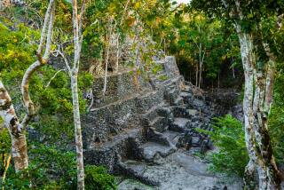
The images also reveal a previously undiscerned mound near the edge of Angkor Wat. When Moore visited the mound in December, she found the remains of as many as six temples, some of which suggest the earlier origin of the city.
“The radar maps not only bring into question traditional concepts of the urban evolution of Angkor, but reveal evidence of temples and earlier civilizations either absent or incorrect on modern topographic maps and in early 20th century archeological reports,” Moore said last week when the latest details were revealed at a JPL news conference.
“Fifty years ago, we thought that the history of Angkor was well known,” said Claude Jacques of the Ecole Pratique des Hautes Etudes in Paris. “Now I find myself changing my mind every year.”
The Angkor Wat temple complex was designed by King Jayavarman II, ruler of the Khmer empire from 802 to 850 AD. He started construction, but it was not finished until the reign of King Suryavarman II, from 1113 to 1150.
The main temple, which is surrounded by a moat and approached by a massive causeway, is the crown jewel of more than 60 temples that dot the area. At the Angkor region’s height, the temples served a population of more than 1 million.
The Khmer people fled the region in the 14th century, fearing attacks from the Siamese army, and the Wat became a Buddhist pilgrimage center. In 1431, it fell to the Siamese and was eventually overgrown by the jungle, not to be seen again until French archeologists rediscovered it in the 1860s.
More recently, the region has been a stronghold of the Khmer Rouge during two decades of war, and large areas remain impenetrable because of their presence and leftover land mines.
The first recent images of the region were taken by the JPL radar when it was carried on the space shuttle Endeavour in 1994. Other images from that flight revealed the long-lost city of Ubar in Oman. The most recent images were taken in December 1996 when the radar toured the Pacific Rim on a NASA DC-8. That trip also provided new views of the Great Wall of China.
Working with three-dimensional images produced from the shuttle radar views, the team discovered a large, shallow mound right next to the Wat. Moore visited the mound, called Kapilapura, in December 1997 and discovered the remains of several previously unknown temples, some of which were clearly built well before the Wat itself. The temples include representations of the Hindu deities Vishnu and Indra, as well as inscriptions.
Indra is often depicted on Khmer lintels because of his ability to bring rain. That talent is important in Cambodia, where the monsoon months of May through October are usually followed by five to six months of dry weather with no rain.
*
The presence of the depictions on the older temples indicates that Angkor Wat was a sacred place long before the famous temple was built.
“This suggests occupation of the 12th century site some 300 years earlier, radically changing accepted chronologies of the site,” Moore said.
The images also show a complex of straight lines extending north of Angkor Wat, which the team believes may be the remains of the city that sat next to the site’s temples and palaces. Such features, which are not readily visible on the ground, stand out clearly on the radar images, revealing what may be the remains of old roads and walls.
The images also show the presence of another temple about 18 miles northwest of Angkor Wat. That temple is 45 feet high and about the size of a football field--roughly half the size of the temple at Angkor Wat. But the site is in a hostile Khmer Rouge camp and Moore was unable to visit it. The headman in a nearby village confirmed the temple’s existence, however, and said its name is Sman Teng.
More to Read
Sign up for Essential California
The most important California stories and recommendations in your inbox every morning.
You may occasionally receive promotional content from the Los Angeles Times.


