Atop the Sands of Death Valley, a Hidden World of Small Animals
- Share via
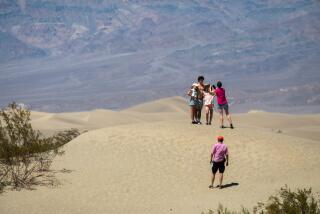
They are not the California desert’s highest, longest or largest, but some dune lovers consider the Panamint Dunes in Death Valley National Park to be the most pristine. The dunes look easy to reach from the road, but a four-mile ascent over the desert floor is required just to reach the base of the tallest, most attractive dunes.
After reaching the top of the star-shaped dunes, most hikers think their effort and time were well spent. The Panamints, like dune ecosystems elsewhere, appear devoid of life but actually offer habitat for several plants and animals. The most visible flora is dune grass, which thrives on the north side of the dunes. Also look for the tracks of the Mojave fringe-toed lizard, kangaroo rat and kit fox.
The best time to take this hike is November through April.
Directions to trail head: From California Highway 190 at Panamint Springs, drive five miles east to Panamint Dunes Road, also called Big Four Mine Road. Turn north (left) and go six miles on the rough gravel road; passenger cars with high ground clearance should do fine. Park when the road begins to swing right toward a mine.
The hike: From the parking area, begin hiking toward the dunes across a rock-strewn alluvial fan that, fortunately for the feet, soon gives way to compacted sand. About 21/2 miles more of tramping across open sand brings you to the base of the dunes.
You will ascend in the company of creosote bushes, your progress slowed by softer sand. After more than a mile, you’ll gain the lower edges of the highest dunes.
Improvise a climb over the ridges and around the hollows of the shifting sand to reach the narrow ridgeline. From atop the dunes, the vista is dreamy: the shimmering Panamint Valley extending far south, the Cottonwood Mountains to the east, colorful Panamint Butte to the southeast and civilization, in the form of Panamint Springs, to the southwest.
Pay particular attention to Telescope Peak to the far southeast. If you navigate straight toward the peak on your return route, you’ll be walking back toward your starting point.
*
For more of John McKinney’s tips, visit https://www.thetrailmaster.com.
More to Read
Sign up for The Wild
We’ll help you find the best places to hike, bike and run, as well as the perfect silent spots for meditation and yoga.
You may occasionally receive promotional content from the Los Angeles Times.


