Ground Shifted Beneath Levees
- Share via
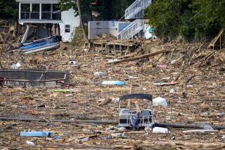
The rapid sinking of the Louisiana coast may have lowered New Orleans levees and contributed to their failure after Hurricane Katrina, resulting in the city’s catastrophic flooding, engineers and other experts say.
Levees and storm walls may be as much as 2 feet lower than they were designed to be, both because elevation data were outdated when the levees were built and because the land has continued to sink, they say.
Experts had sounded alarms in recent years about subsidence, as the sinking is known, warning that the coast was far more vulnerable than most people realized. Federal officials and levee managers say they will begin reviewing the problem in coming weeks.
Subsidence is one of several factors experts are scrutinizing to determine why three levees failed, leaving 80% of the city underwater and hundreds dead.
Experts also are studying the Army Corps of Engineers’ 1990s project that topped existing earthen levees with concrete walls to strengthen New Orleans’ hurricane defenses. The approach was economical but may have left the walls weaker than intended. Three concrete walls failed after Katrina hit Aug. 29, to catastrophic result.
Engineering experts say the designs failed to use the most modern technology, had almost no redundancy to compensate for minor problems during a storm, and were further undermined by weak clay soils in the New Orleans area.
Ivor L. van Heerden, deputy director of the Louisiana State University Hurricane Center, said he was concerned that serious design defects had contributed directly to the wall failures. He has called for an intensive independent investigation.
The corps plans to conduct its own probe with outside experts.
Meanwhile, the corps has quietly been withdrawing its early conclusions about why the levees failed.
Within days of the flooding, federal engineers asserted that the flood-control system was simply never designed for such a powerful storm.
Now, with evidence suggesting Katrina’s intensity fell within the range the levees should have handled, corps spokesmen are saying the organization wants to conduct a full-scale analysis of the design and construction of the levees.
The levee system was designed to withstand a Category 3 hurricane. Katrina’s winds had weakened to 125 mph by the time it reached New Orleans, consistent with a Category 3 storm, according to meteorologist Chris Landsea of the National Hurricane Center in Miami.
Surges from the Gulf of Mexico and Lake Pontchartrain spilled over the walls at the 17th Street Canal, London Avenue Canal and the Inner Harbor Navigation Canal, say Army officials and experts at the New Orleans Sewerage and Water Board, which operates the city’s pumping stations.
Subsidence may have lowered the levee tops, helping to cause the failures, Louisiana State University engineering professor Roy K. Dokka said.
In other areas, including eastern New Orleans, overflow destroyed many miles of levees.
Though it is well known that the Gulf Coast is sinking from Corpus Christi, Texas, to Pensacola, Fla., the rate of subsidence is poorly understood, and many levees in swampy southern Louisiana are significantly lower than they were designed to be, Dokka said.
Many levees are supposed to be 12 or more feet above sea level, but their construction in some cases was based on 30-year-old land surveys.
Dokka had warned in the last two years of an approaching disaster. “The most recent data shows that all of the previous subsidence work was faulty,” he said.
On average, coastal Louisiana has been sinking half an inch annually, he said. But New Orleans East, which saw devastating flooding when levees overflowed, is sinking faster. Many levees are at least 6 inches lower than they were designed to be, and those in New Orleans East and badly damaged Plaquemines Parish are perhaps 2 feet lower.
Such margins could have made the difference in whether the walls failed.
“In East New Orleans, there is no doubt in my mind subsidence is an issue,” Dokka said.
Geological and human forces are causing land elevations to drop, said Virginia R. Burkett of the U.S. Geological Survey’s National Wetlands Research Center in Louisiana.
Over thousands of years, coastal subsidence was offset by Mississippi River sediment deposits, Burkett said. But dams and other water projects on tributaries have halved river sediment since 1950, and levees on the main river channel now carry the remaining sediment deep into the gulf rather than spreading it along the coast.
Offshore oil and gas extraction have accelerated subsidence in some areas, Burkett said. And swamp drainage, particularly under New Orleans, has caused organic soil matter to decay and compact, adding even more to the subsidence.
As levees have sunk, melting glaciers have lifted ocean levels globally, she added.
The problem is expected to worsen in the coming century, further compounding the risk to New Orleans, a city below sea level and at the crown of the Gulf of Mexico hurricane alley.
In presentations to government panels and in scientific papers, Burkett warned last year that subsidence and rising sea levels “portend serious losses of life and property in the New Orleans area, unless flood-control levees and drainage systems are upgraded.”
Determining elevations along hundreds of miles of levees might seem straightforward, but in fact it is highly complex and at the center of a recent multimillion-dollar federal effort.
In 2001, the National Geodetic Survey warned Congress that elevation surveys for Louisiana were “obsolete, inaccurate and unable to ensure safety.”
Two years ago, the agency began recalibrating Louisiana elevation data using the Global Positioning System, Deputy Director David Zilkoski said. But Katrina struck before the project could make a difference.
In the year before Katrina, Zilkoski said, he went from town to town to warn local officials that elevation data in the region were inaccurate, including those that showed evacuation routes.
“We told people, ‘Here’s the bottom line: You are lower than our published numbers,’ ” Zilkoski said.
The issue has grabbed the attention of the Army Corps of Engineers. In coming weeks, Zilkoski said, he will begin helping officials from corps headquarters examine whether levees are lower than they were designed to be.
Meanwhile, LSU’s Van Heerden expressed concern that the 1990s work to place concrete walls atop levees might have contained fundamental design flaws.
The new walls were tied into existing steel sheeting inside the earthen levees. In some cases, the tops of the steel and the footings of the new concrete walls overlapped by just 2 feet. Steel reinforcement bars were welded or looped into the sheeting to tie the structures together, he said.
Van Heerden said he believed the walls on the 17th Street and London Avenue canals failed because they could not resist the water pressure, not because of overflow or foundational erosion.
He said the storm walls snapped where the steel sheeting met the concrete walls. He said it was generally bad practice to use old sheeting as a foundation.
Katrina would also have weakened the levees’ clay soils, a further potential cause of failure.
Geotechnical engineering professor Dobroslav Znidarcic of the University of Colorado at Boulder said he was surprised concrete walls were used for the levees.
Few retaining walls are made of reinforced concrete anymore, he said. Instead, “mechanical stabilized earth” can provide greater strength and resistance to total failure. The system, developed in the late 1980s, sandwiches fabric grids between layers of soil.
“I am concerned their design is prone to catastrophic failure if anything goes wrong,” he said. “It does not have a sufficient level of redundancy.”
More to Read
Sign up for Essential California
The most important California stories and recommendations in your inbox every morning.
You may occasionally receive promotional content from the Los Angeles Times.


