Red flag conditions taper off in Southern California while north looks ahead to windy, dry weather

- Share via
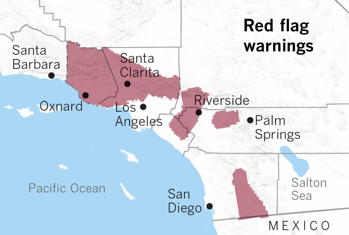
A red flag warning remained in effect for much of Southern California through Sunday evening, as above-average temperatures and dry winds gusting up to 50 mph contributed to dangerous fire conditions.
Warnings were in effect from Ventura County through parts of Orange County, the Inland Empire and San Diego County, according to the National Weather Service.
The mountains of Los Angeles County and the San Fernando and Santa Clarita valleys were also at high fire weather risk, with Santa Ana winds peaking and temperatures surpassing 90 degrees in some areas. Downtown Los Angeles set a daily record with a high of 92 degrees, Los Angeles International Airport hit 91 degrees, and Anaheim reached 94 degrees.
Relative humidity, a measure of how much water vapor is in the air, was between 8% and 15%.
“It’s pretty darn dry out there,” said Kathy Hoxsie, a meteorologist with the National Weather Service in Oxnard.
The red flag warning remained in effect until 6 p.m. Sunday. Regions covered by the warning have experienced large wildfires in recent weeks, including the Tick fire in Santa Clarita, which burned more than 4,600 acres, and the Easy fire in Simi Valley, which burned more than 1,800 acres.
Southern California Edison said it had notified 5,656 customers of a possible power outage within 48 hours but had not yet shut off any lines. The majority of those customers were in San Bernardino County, but some in Santa Clarita, Agua Dulce and Palmdale also received the notification.
Temperatures across L.A. County are expected to dip slightly Monday with most of the region continuing to see temperatures in the high 80s and low 90s before dropping into the 70s on Tuesday, as clouds and moisture from the south move in, Hoxsie said. The system may bring up to half an inch of rain to the county’s eastern side, particularly the San Gabriel Mountains, on Wednesday. That would be enough to wet potential fire fuels, including grass and trees under a canopy cover.
All of coastal Southern California is abnormally dry, according to data released by the U.S. Drought Monitor last week. Very dry weeds and grasses that grew after the last rainfall season, combined with dead vegetation, are a potential fire fuel and of special concern during red flag weather conditions.
“Every day we get closer to it, we’re feeling more confident that we should have precipitation, which is fantastic,” Hoxsie said.
In Northern California, which is also abnormally dry, weather and utilities officials are warning of possible red flag conditions midweek.
Eric Kurth, a meteorologist with the National Weather Service in Sacramento, said relative humidity in the northern Sacramento Valley and the coastal range mountains could drop into the teens Wednesday and Thursday, and drying Diablo winds — the north’s version of Santa Anas — could gust up to 50 mph.
Pacific Gas & Electric Co. warned of a possible “public safety power shut-off” for some customers in the Sierra foothills, northern Central Valley and North Bay if fire conditions persist. Downed power lines have been blamed for igniting fires throughout the state.
PG&E, the state’s largest utility, initiated multiple rounds of shut-offs in October and plunged nearly 2.5 million people into darkness at one point throughout Northern and Central California. Some of the outages lasted several days.
The state’s Public Utilities Commission voted last week to open a formal investigation into the preemptive power outages, which drew strong rebukes from public officials and residents who said the shut-offs were overly broad and poorly executed.
More to Read
Sign up for Essential California
The most important California stories and recommendations in your inbox every morning.
You may occasionally receive promotional content from the Los Angeles Times.


