An atmospheric river with subtropical moisture is taking aim at Southern California next week

- Share via
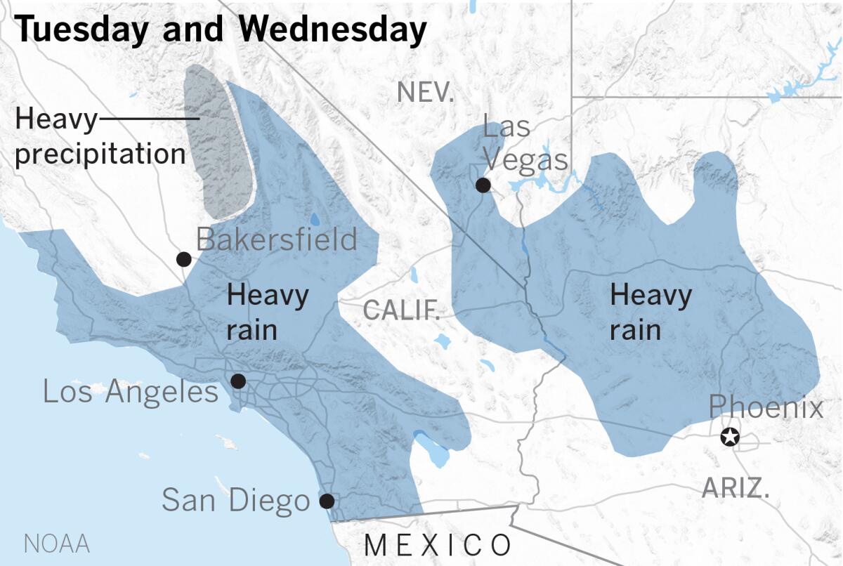
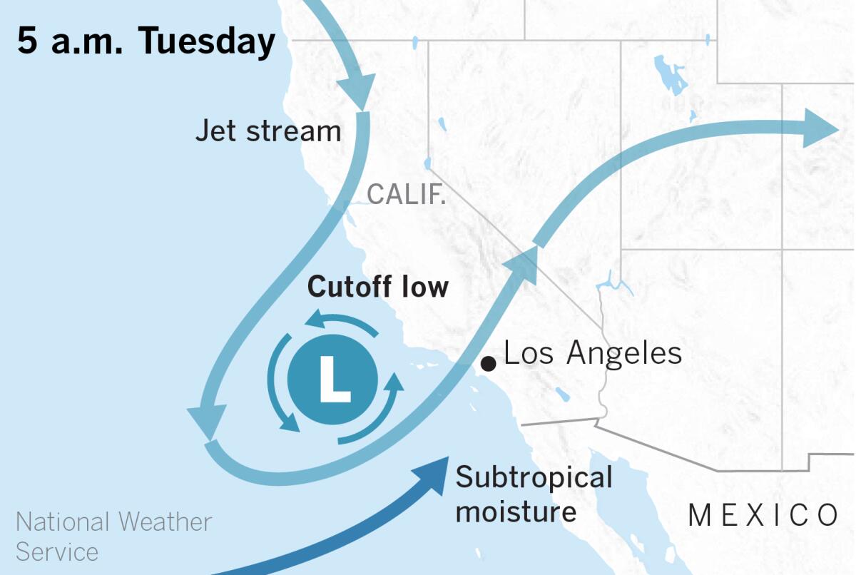
An unstable low-pressure system from the Gulf of Alaska will tap into subtropical moisture, bringing the potential for heavy rain in Southern California on Tuesday and Wednesday, the National Weather Service said. The southern part of the Sierra Nevada could see heavy, wet snow, and parts of Arizona and Nevada are also expected to get heavy rain.
The cutoff low will merge with a weak to moderate atmospheric river, focusing precipitation on Central and Southern California.
Atmospheric rivers are a concentrated stream of water vapor in the middle and lower levels of the atmosphere. The stream of moisture moves across the ocean without interruption until it encounters an obstacle such as coastal mountains in California. Lifting up and over these mountains causes the moisture to condense and fall as precipitation.

The instability of the low-pressure system will make thunderstorms with downpours and small hail possible. Rainfall rates of up to 1 inch per hour are possible in the thunderstorms. There is a limited risk of mud and debris flows in first- and second-year burn areas because of the potentially heavy downpours. Minor urban flooding and rock falls on canyon roads are also possible. There will be heavy seas with gale-force winds off the coast, and beach lightning is possible.
Snow levels will remain well above 7,000 feet until late Wednesday because of the warm nature of the storm, but accumulations of 1 to 2 feet are possible at the highest resort levels.
The region could see 60% to 100% of normal March rainfall with this storm, according to Eric Boldt, a meteorologist with the National Weather Service in Oxnard. Monthly normal rainfall is 2 to 3 inches.
This could be “the storm of the season so far,” said Bill Patzert, a former climatologist with NASA’s Jet Propulsion Laboratory, adding that it “could lift us off our knees, but not out of the continuing drought conditions.”
Jan Null, a veteran meteorologist with Golden Gate Weather Services in Northern California, agreed: “Even in the wettest parts of Southern California the amounts won’t move the needle much; even less on the Central Coast and Southern Sierra and not enough to notice at all north of about Monterey to Yosemite.”
“This looks like a Central and Southern California event. Not a Northern California snow maker,” Patzert said.

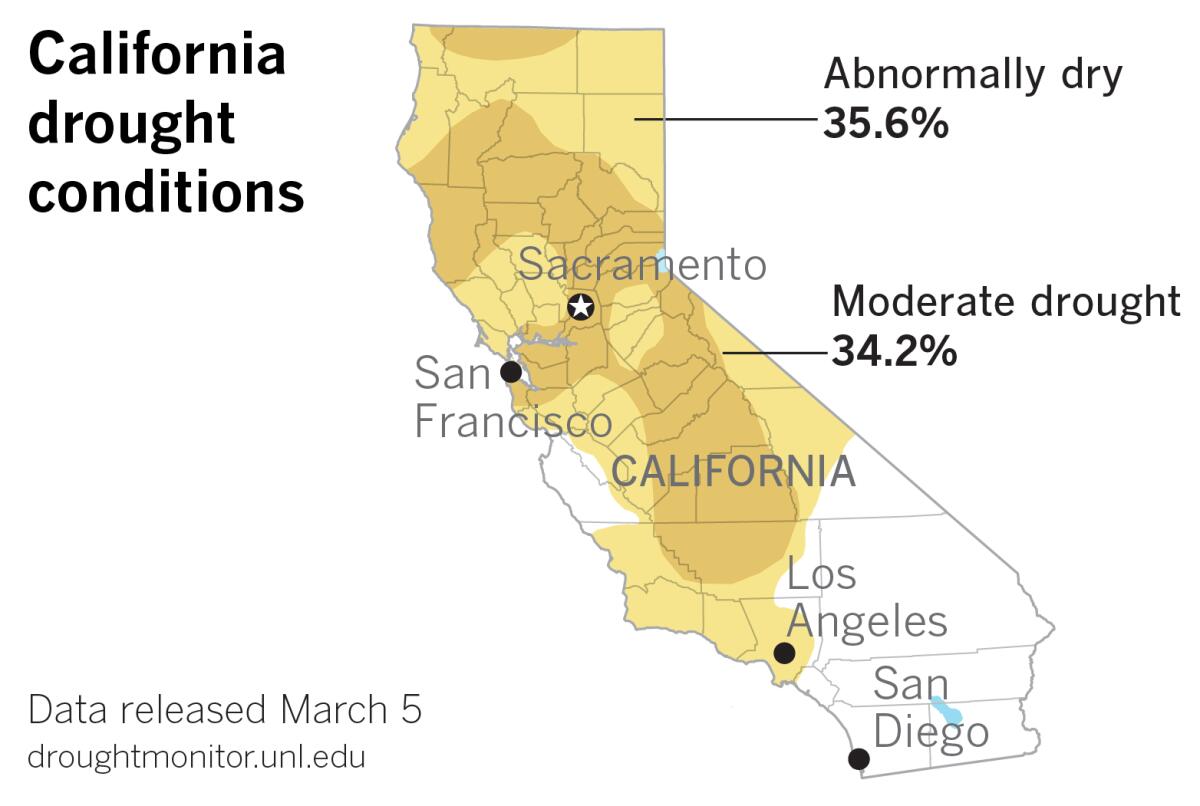
The latest U.S. Drought Monitor report shows that almost all of the areas of the state that are neither abnormally dry nor in moderate drought are in the southern part of the state.
Next week’s storm is expected to begin with rain in San Luis Obispo and western Santa Barbara counties at about sunrise on Monday, with a chance of light rain elsewhere. Rain will spread to all of the Southern California region Tuesday and Wednesday, and peak Tuesday afternoon through Wednesday in Ventura and Los Angeles counties. The coast and valleys can expect from an inch to 2.5 inches, while the foothills and mountains can expect from 2 to 4 inches.
A colder storm is possible the following week on March 17-18 as a wet pattern is expected to continue.
More to Read
Sign up for Essential California
The most important California stories and recommendations in your inbox every morning.
You may occasionally receive promotional content from the Los Angeles Times.


