Wet weather should clear the air in parts of California plagued by smoke since August
- Share via
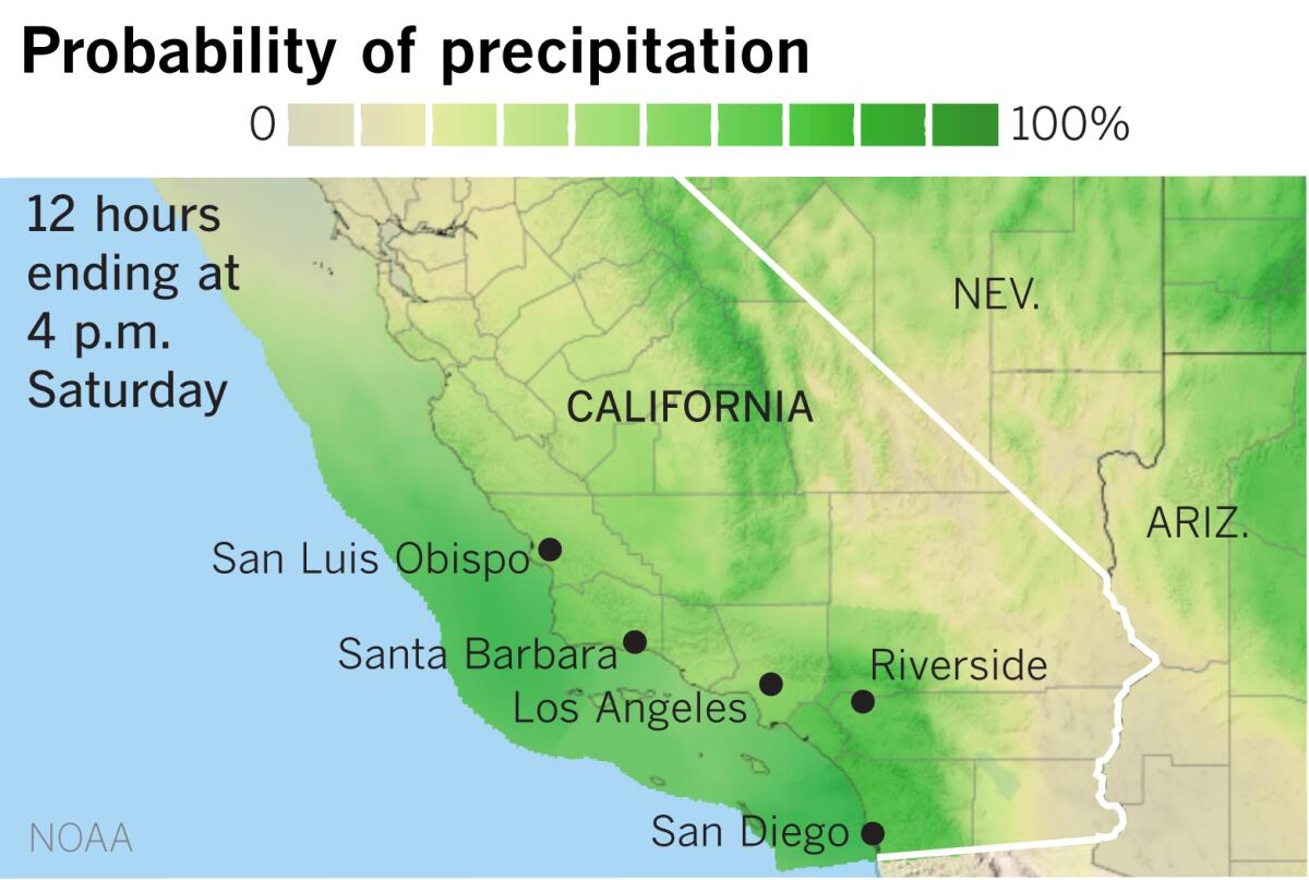
Two back-to-back storms expected this weekend will clear the air for some parts of California that have been besieged by a pall of smoky, unhealthful air since the dog days of summer.
The precipitation will dampen wildfires in the Sierra and finally cleanse the atmosphere in the San Joaquin Valley, said Modesto Vasquez, a meteorologist with the National Weather Service in Hanford. “At least, that’s what we’re hoping for,” he said.
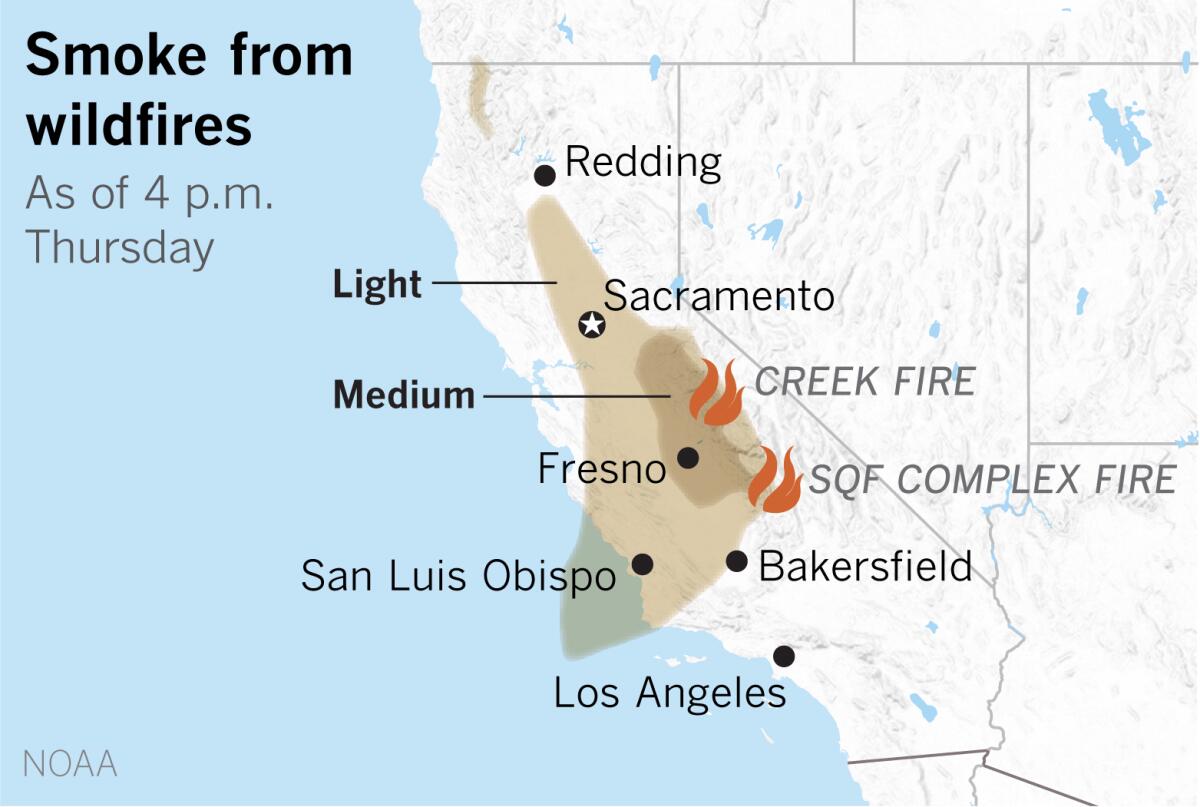
Smoke from numerous fires, including the Creek fire and the SQF Complex fire in the Sierra east of the valley, has choked the air with smoke and particulate matter since the middle of August, the weather service said, adding that the rain “couldn’t be more welcome.”
Initially, winds in advance of the cold front could kick up dust through midday Friday and enhance the fire threat, Vasquez explained. “The fields are very dry, so there could be very dry, dusty conditions on Friday morning,” he said. After that, wind, colder air with precipitation and rising humidity should help the fire situation and clear the air.
A colder air mass behind the first storm could bring snow levels down to 4,500 feet. Interstate 5 through the Grapevine and Highway 58 through the Tehachapi Pass could see ice or light accumulations of snow late Sunday, Vasquez said.
Like the rest of the state, Southern California has suffered with dirty air during this worst-ever fire season — most recently with contributions from the Silverado and Blue Ridge fires in Orange County.
It essentially hasn’t rained in downtown Los Angeles for close to 200 days, climatologist Bill Patzert points out. On April 12, downtown got 0.06 inch of rainfall. Since then, there was the 0.14 inch on May 18, but otherwise it didn’t rain for the last half of April, May — with the exception of that dampening on May 18 — followed by all of June, July, August, September, October and November thus far.
“After seven dry months with record-breaking heat — essentially with no rainfall — the precipitous drop in temperature with our first real rain of the season will be a shocker for Angelenos,” Patzert said. “Regardless, the weather whiplash will be a welcome change and will hopefully dampen this year’s nearly continuous fire season.”
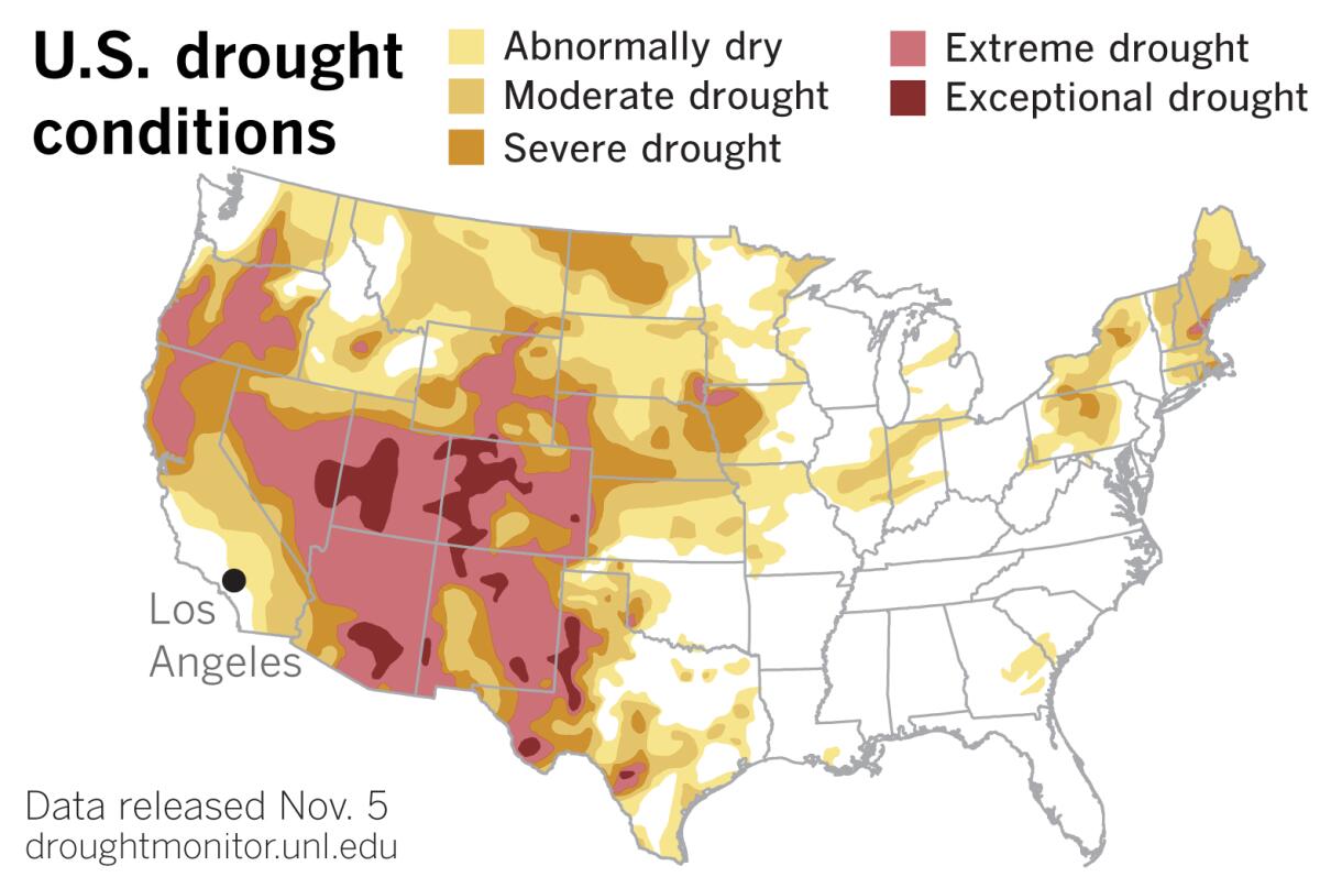
Although there have been some minor improvements in drought conditions in some parts of the West, the Southwest has remained unchanged, the U.S. Drought Monitor reported Thursday.
That means that most of California is unusually dry or in drought. Almost all of Northern California is in severe or extreme drought. An area of moderate drought swings around from Santa Cruz, through the Central Valley toward the Sierra, then southward to Imperial County and the Mexican border. What little is left of the state is either abnormally dry or, in a strip along the coast from Monterey Bay to San Diego, not technically in drought, but nevertheless dry after months of record summer heat and no rain.
The rain expected this weekend will not be a soaking and won’t dent the widespread drought, but Patzert hopes “it will be enough to give the Southland a good rinsing to clean off the soot and ash from recent fires. The Southland needs a good shower.”
More to Read
Sign up for Essential California
The most important California stories and recommendations in your inbox every morning.
You may occasionally receive promotional content from the Los Angeles Times.


