How California is turning drainage canals back to rivers

Under new legislation, long stretches of the river’s flood control channel will have trails and parks
- Share via
The Santa Ana River, born of snowmelt and natural springs near Big Bear Lake, flows through Southern California as one of the region’s most scenic rivers — until it hits Orange County.
After cutting through a deep, lush canyon and flowing through the city of Riverside, the Santa Ana spills into riprap and the county’s dreary concrete flood control channel extending 26 miles to the Pacific Ocean.
The conditions have made the Santa Ana, like other Southern California rivers, a gritty anachronism, especially in a state that prides itself as an environmental leader nationwide. But now, joining a trend that began elsewhere some four decades ago, the Santa Ana is catching up.
“People want their streams back — all of them, including the Santa Ana,” said Stephen Mitchell, a science librarian and co-coordinator of the nonprofit UC Riverside Friends of the Santa Ana River.
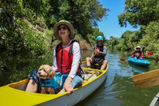
Under recently approved legislation, long stretches of the flood control channel’s banks will have trails, parks and natural areas, and portions of the river itself will be cleared of boulders, low-hanging limbs and other entanglements to open the waterway to kayaking and rafting.
The wonder is that it has taken so long. Many American cities have cleaned up blighted rivers and turned their banks into parks or greenways with entry points that invite visitors to launch canoes, kayaks and boats.
In Reno, the Truckee River Whitewater Park runs through the downtown hotel-casino district. Kayakers paddle New York City’s Bronx River. The Willamette River is now an inviting escape for residents of Portland, Ore.
In Southern California, however, the Santa Ana and half a dozen other once beautiful rivers and streams have remained drainage channels. Their purpose is to prevent the flooding that devastated the region in the middle decades of the last century when flash storms in the San Gabriel Mountains sent massive amounts of water into communities unable to handle the deluge. Too much open land had been developed and paved.
Converting the rivers into efficient drainage channels all but ended the flooding, and for more than half a century, government flood control agencies fought any changes that would diminish carrying capacity, even as environmentalists and river advocates began calling for ecological restoration and recreational improvements in the 1980s.
“They are the last open space we have in working-class and park-poor communities for healthy recreational goals such as walking, hiking and biking trails,” said D.J. Waldie, an author and expert on the local landscape and culture.
But the U.S. Army Corps of Engineers and other flood control agencies wouldn’t budge until the last decade, when commercial interests joined with community activists along the Santa Ana, Los Angeles and San Gabriel rivers — and tributaries including the Rio Hondo, Arroyo Seco and Compton Creek — to demand change.
“The realization that concrete channels can also support park amenities is rising hand in hand with environmental justice concerns,” said Steve Evans, a political consultant for Friends of the River and the California Wilderness Coalition.
“Minority communities, particularly Latino communities along these river systems, are exercising their political power to improve conditions in otherwise park-poor areas,” Evans said.
On the commercial front, the region has grown so dense that river corridors have become frontiers. Industry has been phasing out along the channels and commercial interests have stepped in, seeing opportunities for new housing, retail and office development.
Flood control agencies have for the most part acquiesced, agreeing to improvements that will not reduce carrying capacity during rainstorms.
The Los Angeles River is the best example. It is in the early stages of a renaissance, especially along 11 miles just north of downtown. Now it’s the Santa Ana’s turn.
Under the legislation by state Sen. Lou Correa (D-Santa Ana), the Santa Ana River Conservancy Program will operate within the state Coastal Conservancy to improve conditions for wildlife and provide amenities for hiking, biking, picnicking, fishing, horseback riding and other activities in one of the fastest-growing regions in the nation.
Correa’s measure was modeled after a 17-year-old Coastal Conservancy program dedicated to improving public access to open space and wildlife habitat in the Bay Area.
The Santa Ana, formally known in Orange County as Flood Control Channel EO 1, has numerous hidden, shady places that support a remarkably rich variety of species.
The 2,150 acres of wetlands behind Prado Dam near the Orange-Riverside county border, for instance, comprise a labyrinth of channels, ponds and forests. Despite a development boom in neighboring Chino, Corona and Norco, the wetlands area is still a haven for threatened and federally endangered species including red-sided garter snakes and least Bell’s vireos.
High on Correa’s wish list of recreational projects is construction of 30 miles of trail to complete a 110-mile-long trail from Big Bear Lake to Huntington Beach.
Ultimately, the trail could link a network of river-bottom parks. The city of Redlands, for example, plans to develop riverside green space beneath the San Bernardino Mountains to attract hikers and bicyclists, some of whom would shop and dine in its nearby historic downtown district.
David Myers, executive director of the nonprofit Wildlands Conservancy, and other naturalists recently obtained permission from state parks officials to navigate the stretch of river flanked by Chino Hills State Park on the north and the Cleveland National Forest on the south. They wanted to explore the possibilities of improving public access and recreational opportunities.
The rafters made their way down two miles of river, pulling their way through a tunnel in dense overhanging willow branches, often leaping overboard to give their boats a shove.
Finally they reached a point where the vegetation was impenetrable. They dragged the rafts onto a sandy bank, sopping and exhilarated.
“This place has great potential,” Myers said. “In five or six years, much of this river could be beautiful riparian forests with shady trails.”
@Louis.Sahagun
More to Read
Sign up for Essential California
The most important California stories and recommendations in your inbox every morning.
You may occasionally receive promotional content from the Los Angeles Times.


