After ‘pretty extraordinary’ snowfall, Sierra Nevada braces for another battering from atmospheric river

- Share via
Reporting from TRUCKEE, Calif. — Across the Sierra Nevada this weekend, residents and officials are assessing the damage from a series of powerful storms before a new round from the atmospheric river arrives next week.
Some homes in northern Sierra communities have been left without power for more than a week because of this week’s blizzard, which locals say has been the worst in a decade.
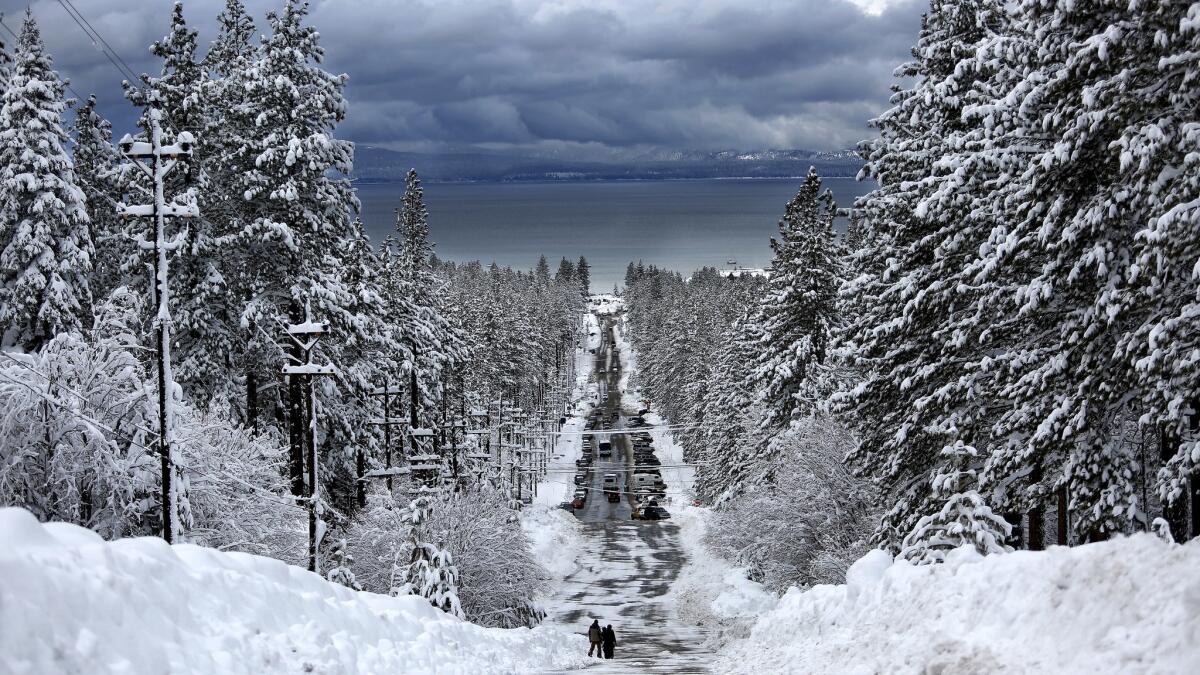
“We had over 10 feet of snow in portions of the community. Everyone had at least 3 to 5 feet of snow, all in about a two-day period. And that’s a pretty extraordinary level of snow,” said Truckee Donner Public Utility District spokesman Steven Poncelet.
The culprit was a moment in the middle of the week when the storm became warmer. Instead of causing nice, dry powder that comes with colder storms, this system dumped slushy, dripping, heavy snow, which locals call “Sierra cement.”
That wet slop stuck to electrical lines and tree limbs. When branches weighed down by snow snapped, they took out power lines with them. Combined with high winds, it was a recipe for problems.
For Truckee, the series of blizzards has been so bad that the schools have been closed because of snow for eight consecutive days, something locals can’t remember happening in decades. Some residents have been trapped in their snowbound homes for three days, with some roads only plowed Friday since the last storm began. Even the U.S. Postal Service was forced to close nine post offices Thursday, citing the lack of power and access.
Poncelet warned that people returning to their second homes in Lake Tahoe for the Martin Luther King Jr. Day weekend could find downed trees and power lines, and a lot of snow to shovel just to get to their doorway.
But the predicted arrival of another big storm next week could pose problems in Truckee, where rain could cause flooding problems.
“You’re going to have now a massive amount of snow on the ground that the rain is going to essentially melt, so the chances of flooding and mudslides is going to be pretty high,” Poncelet said.
This week’s storms cut off mountain passes and contributed to at least four deaths, and forecasters say there’s no sign of a prolonged dry spell anytime soon. Months of intense rain and snow ended a five-year drought for much of Northern California, though the south of the state is still dealing with water shortages.
“Atmospheric rivers happen every year. And for whatever reason, they have been missing California for the last several years,” said Tom Dang, a National Weather Service meteorologist in Sacramento. “And they are just aimed at us one right after another this year.”
The next storm is expected by Wednesday.
“Taking any kind of action to be prepared is better than taking no action and just thinking about it,” said Brad Alexander, spokesman for the California Office of Emergency Services. “If people were impacted by these last storms … they need to quickly get their emergency plans together. This last one is proof that you need to have one right in front of you.”
At least 20 towns, cities and counties have declared states of emergency as a result of the most recent set of storms, Alexander said. Dramatically, all of Truckee and the California side of Lake Tahoe lost power for more than 12 hours after a large tree fell on the main electricity transmission line in the region.
Rural residents in the Napa and Sacramento valleys were flooded out of their homes when heavy rain and snowmelt overwhelmed local rivers.
Major highways that were damaged by rock- and mudslides or flooded may be eligible for federal aid, Alexander said. State officials are going door to door to assess the damage but will have their work slowed by next week’s storms.
“It would be like one major fire series happening right after another major fire series,” Alexander said.
With the biggest blizzard in a decade under their belt, Californians need to work for the next few dry days to clear snow- and leaf-clogged storm drains before the next system hits, the National Weather Service warned.
“Flooding is definitely a concern,” said Dawn Johnson, meteorologist with the weather service’s Reno office. There is so much precipitation across the Sierra Nevada — at 163% of its historical average Friday, with nearly 20 feet of snow accumulated at Mammoth Mountain and more than 23 feet at Northstar. Flooding is a risk especially at creeks, streams, ditches, low-lying areas and anywhere that has poor drainage.
“Because we’re so saturated, all these smaller streams could flood easily,” Johnson said.
Next week’s version is shaping to be a weaker relative of an unusually warm storm that struck the Sierra last weekend, which dumped 8 to 12 inches of rain on the high Sierra crest before the midweek blizzard. But the latest forecast has some reason for optimism — it’s more cold, less wet and not as powerful: only 2 to 4 inches of rain is currently expected to fall on the crest of the mountain range. Rain is expected at elevations lower than 8,000 feet, meaning rain could arrive at the base of some ski resorts while snow falls at the peaks.
Next week’s storm will melt some snow, but not the entire snowpack, Johnson said.
California’s water year — which runs from Oct. 1 to Sept. 30 — started off remarkably, with four times October’s average rainfall, according to the Department of Water Resources. Though November lagged behind, storms in the last two months have helped the northern half of the state bounce back from years of drought.
According to the U.S. Drought Monitor’s report released Thursday, more than 40% of California is out of drought conditions, all of it in the northern half of the state. Southern California’s conditions have also improved, but it would take at least another year of above-average rainfall to replenish reservoirs and groundwater basins, officials said.
Southern California could receive up to 2 inches of rain with next week’s storms, forecasters say.
Despite the weather headaches, many were still celebrating the best snow year in recent memory. At the Donner State Memorial State Park Visitor Center on Friday, there was already 4 to 5 feet of snow on the ground — and it’s only the middle of January, marveled Nikki Combs, a park interpreter. During drought years, there were only 2 to 3 feet of snow.
The roads into Tahoe were already getting jammed Friday, even though snow chain restrictions had been lifted. With blue skies forecast, Combs predicted, “everyone is going to be here.”
For locals, there has been a mix of excitement over the snow and weariness from having to deal with power outages and constant snow shoveling.
“Those of us who are here because we love the mountains, this is wonderful. Everybody loves it,” said Kim Szczurek, administrative services director for the town of Truckee. But with all the fallen trees, damage to roads and drainage systems and difficulty plowing the streets, “it’s just difficult to deal with.”
Lin reported from Truckee and Serna from Los Angeles.
ALSO
Laurel Canyon closed ‘until further notice’ after mudslide
Heavy rain topples massive tree in Northridge
Two out of three Border Patrol job applicants fail polygraph test, making hiring difficult
UPDATES:
5:32 p.m.: This post was updated with material from Truckee.
More to Read
Sign up for Essential California
The most important California stories and recommendations in your inbox every morning.
You may occasionally receive promotional content from the Los Angeles Times.


