Caltrans Tries to Answer Day’s Toughest Questions
- Share via
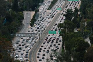
You’re driving down the Santa Ana Freeway and the traffic seems to be flowing smoothly -- perhaps a little too smoothly. Is gridlock just beyond the next curve?
The California Department of Transportation unveiled a new system on Monday that is expected to help motorists answer that question. It won’t ease congestion, but officials are hoping it will ease congestion anxiety.
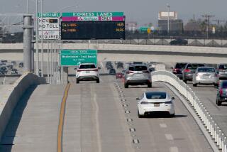
Caltrans is posting estimated travel times on 14 electronic freeway signs across the region, part of a pilot program that the agency eventually hopes to expand.
On the westbound Santa Monica Freeway in downtown Los Angeles on Monday afternoon, a flashing sign told motorists that the drive to the San Diego Freeway should take 10 minutes. The sign was so jarring that traffic nearly came to a halt as motorists slowed to read it. But past the sign, congestion cleared, and the trip actually took about seven minutes.
“It gives motorists more information so they can make decisions on how they will like to plan their commute,” said Caltrans spokeswoman Jeanne Bonfilio. “If we give them a travel time, they can say ‘I might want to take this route instead.’ We are trying to put travel information into the hands of the motorists.”
The information on the signs comes from 15,000 sensors Caltrans has placed on freeways to measure traffic speed. The fiber optic system has a sensor every half mile of urban freeway, transmitting information every 30 seconds. Officials pick key commute markers and calculate the commute time given the traffic flow. Each sign contains commute times for two destinations.
Rosane Castro noticed the sign Monday morning while driving east on the Pomona Freeway to her job as a court reporter. It reported relatively normal conditions, so she stayed on her usual route. But she said she would consider changing her commute if the sign reported a major delay.
“It’s just quicker to look at the sign so you can make a decision on which way to take,” said Castro, 35. “We are known for having bad traffic, and it seems like somebody is taking time to think about changing that.”
Estimated commute times are posted on electronic signs in other cities, including Chicago and San Francisco, where officials report generally positive results.
Jack Gaines, a spokesman for the Caltrans division serving the Bay Area, said the signs have been most helpful in calming drivers by informing them of delays ahead. He said he suspects the tips have helped reduce road rage by giving motorists the option of finding detours before the traffic backs up.
“People don’t swerve as much anymore. They don’t freak out wondering how long it’s going to take,” he said. “They can gauge or they can call ahead and say ‘I’m going to be late,’ because they know how long they’re going to be stuck in that jam.”
Traffic experts agreed that knowing about delays beforehand could relieve on-the-road tension.
“In general, the research shows very clearly that the better information about arrival time significantly reduces the burden people perceive,” said Brian Taylor, director of UCLA’s Institute of Transportation Studies. He pointed to a study showing people felt less stressed on the Metro’s Rapid bus line when they were able to see how many minutes until the next bus arrived.
“Improving people’s states of information will in general make them less frustrated,” said James Moore, chairman of USC’s Daniel J. Epstein Department of Industrial and Systems Engineering.
In the past, Caltrans has hesitated to use the changeable message signs because they create some congestion as people slow to read them, Moore said. Caltrans is reluctant to give commuters instructions, he said, because that might create legal liability. But Moore said he applauds Caltrans’ initiative.
Hamid Bahadori, a principal transportation engineer for the Auto Club of Southern California, said the success of the program will depend in large measure on whether Caltrans can provide accurate and timely information. He noted that travel times alone do limited good for motorists unless they can figure out alternative routes.
“If I see the travel time is 15 minutes but I get on the freeway and it really takes me 45 minutes, the information is not reliable, and people will learn to categorically dismiss it,” Bahadori said. “This information is going to be more useful in connection with more alternative routes.”
The new project won’t cost additional money because the sensors and freeway signs are already in place. The test period will last for three to six months on the 14 initial signs. If all goes well, Caltrans plans to extend the program to all 120 freeway signs across the region, said spokeswoman Deborah Harris.
A sign on the southbound Golden State Freeway in Pacoima lists times for the Ventura Freeway and downtown. A sign on the eastbound San Bernardino Freeway in City Terrace lists time for the 605 Freeway and the Orange Freeway. The times are posted between 5 a.m. and 7 p.m.
Although some motorists reported delays as drivers slowed to read the signs, experts don’t expect the delays to continue. Bahadori said there were similar bottlenecks three years ago when Caltrans started placing Amber Alerts on the electronic signs. But those delays eventually eased as motorists became more familiar with the signs.
Until now, Caltrans has relied on radio stations to get the word out about traffic accidents and delays. Luis Rivera, a producer for Airwatch America, which provide traffic updates for KFI-AM (640), believe the signs will be a useful tool but won’t be competition for him.
“In a way, I think, it probably helps out,” he said. “We’re all in the same game and we work closely with Caltrans” and the California Highway Patrol.
Commuters are quick to note that the signs can help only so much.
“There has to be more freeways,” said Jeff Sun, 43, who commutes daily from Chino Hills to downtown Los Angeles. “If you put a sign, it doesn’t help.”
*
(BEGIN TEXT OF INFOBOX)
Estimated travel times
Caltrans posts estimates at 14 locations to indicate how long it should take to reach two destinations.
*--* Sign location First destination Second destination Eastbound Santa Monica at Downtown 605 Freeway National Blvd. Eastbound Pomona at 605 Freeway Orange Freeway Indiana St. Southbound Ventura at 134 Freeway Downtown White Oak Ave. Southbound Golden State at Long Beach Freeway 605 Freeway Broadway Westbound Santa Monica at San Diego Freeway Pacific Coast Highway Western Ave. Northbound Hollywood at San Diego Freeway Moorpark Freeway Melrose Ave. Eastbound San Bernardino 605 Freeway Orange Freeway at City Terrace Drive Northbound Harbor at Century Freeway Downtown Pacific Coast Highway Northbound San Diego at Harbor Freeway LAX Lakewood Blvd. Northbound Golden State at Ventura Freeway Ronald Reagan Freeway Stadium Way Westbound Century at Harbor Freeway LAX Lakewood Blvd. Eastbound Century at Van Long Beach Freeway 605 Freeway Ness Ave. Westbound San Bernardino 605 Freeway Downtown at White Ave. Southbound Golden State at Ventura Freeway Downtown Terra Bella St.
*--*
Los Angeles Times
More to Read
Sign up for Essential California
The most important California stories and recommendations in your inbox every morning.
You may occasionally receive promotional content from the Los Angeles Times.


