Counts, Maps, Photographs 450 in National Park : Geographer Takes Note of Utah’s Arches
- Share via
PROVO, Utah — Park rangers in Utah’s Arches National Park have never been able to tell visitors exactly how many natural rock arches exist in the park.
One of nature’s rarest and most beautiful creations, the majestic structures rise from the red sands of the southeastern Utah desert, spanning anywhere from a few inches to more than 300 feet.
Dissatisfied with the lack of information on the arches, Dale Stevens, professor of geography at Brigham Young University, took a semester-long leave from teaching duties to study and map them.
With a grant from the BYU College of Family, Home and Social Sciences, Stevens spent last fall searching throughout the park and measuring, photographing and classifying every arch he could find. Now, he may know more about the arches than anyone else.
Number on List Grows
Just 12 years ago, only 88 arches had been identified. By the fall of 1984, when Stevens began his study, the number was 288. When he finished, he had a list of more than 450.
Arches can be found in many countries, but no other area of the world has as many as the Four Corners section of the United States--the chunk of land where corners of Utah, Arizona, Colorado and New Mexico meet. Arches National Park gave Stevens a defined, workable area to study, so he confined his research within its boundaries.
Teaming up with Ed McCarrick, a retired accountant from New Jersey and part-time ranger with the National Park Service, Stevens divided the park into 12 sections and scouted each one methodically.
“The big difficulty was just finding them all,” says Stevens. Arches National Park covers 114 square miles, 73,234 acres. “The areas where arches are found are made up of standing rocks, pinnacles and fins. Once you’re within them it’s like a maze.
“We had to climb to several of the arches and rappel down to some of them to take measurements.”
Slow Weathering Process
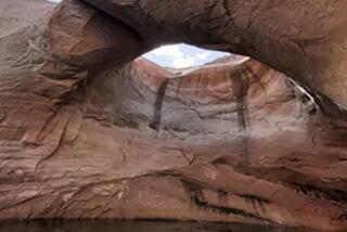
The formation of an arch takes anywhere from several hundred years to hundreds of thousands of years, Stevens says. The first requirement is a slab of vertical rock, usually sandstone. The weathering process slowly eats away at the rock, first forming a cave-like indentation, then giving way until light is visible through it.
Neither water nor wind “cuts a hole through” the rock, as is commonly misunderstood, he explains, but stress lines develop in an arched form at weak points, such as in bedding planes (where one rock mass rests upon another), until the weight of the rock bears down and the weak material falls away.
Eventually all arches fall, and Stevens has observed the formations in their various stages. One arch looks as if little more than a touch of the finger would collapse it, while the height of rock above the opening of another is well over 200 feet.
Free-standing arches are visible from all sides; cliff wall arches have a cliff as a backdrop; and natural bridge arches span water courses.
The result of Stevens’ research will be two products: a book co-authored by Stevens and McCarrick, and a map of the park with each arch pinpointed. The reverse side of the map will give historic, geological and descriptive information about the arches. The book will contain a photograph of each arch, a description of it, how to get to it and what stage of formation it is in.
More to Read
Sign up for The Wild
We’ll help you find the best places to hike, bike and run, as well as the perfect silent spots for meditation and yoga.
You may occasionally receive promotional content from the Los Angeles Times.


