Berth Site May Have Been Too Shallow for Ship
- Share via
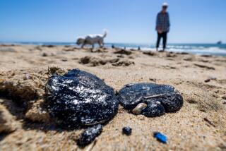
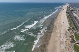
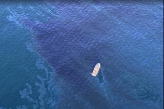
The tanker American Trader may have been operating in water five feet shallower than indicated on depth charts when it apparently impaled itself on its own anchor and spilled 394,000 gallons of crude oil in the ocean off Orange County, a Coast Guard official said Wednesday.
Authorities have turned up “preliminary indications” that the 811-foot tanker may have been operating in 46 or 47 feet of water instead of the 51 to 53 feet listed on navigational charts, said Cmdr. Scott Porter, Coast Guard assistant chief for marine safety in California.
If that discrepancy proves true, it would mean the ship may have had less than five feet of water under its hull as it passed over its anchor, which is about 4 feet wide and 10 feet long.
The ship’s anchor apparently punched two holes in the hull, triggering the worst oil spill in two decades off Southern California. Some Coast Guard officials have speculated that a depth discrepancy may have occurred when sand from the shore was swept by currents, forming a shoal.
Concerned that the depth changes might have been a factor in the accident at an oil pipeline mooring off Huntington Beach, the Coast Guard has decided to look for similar potential safety problems at about 15 other berths off the California coast.
“We want to make sure this is not a problem that could result in a disaster anywhere else,” Porter said. “The fact that this one (off Huntington Beach) has been used safely for years and years, and now there’s a problem, certainly raises a question with the others.”
Porter emphasized that the Coast Guard was undertaking the action as a precaution. Authorities would “take appropriate actions within the Coast Guard regulations” if other apparent discrepancies crop up at other moorings.
Although the Coast Guard has shut down the Huntington Beach mooring to vessels with a draft--the depth of water that a vessel draws--of greater than 20 feet, the other on the California coast remain open.
The National Oceanic and Atmospheric Administration supplies navigational charts for waters off the United States. Those charts are updated weekly using reports of depth changes or obstacles supplied to the Coast Guard by captains.
Brian Gorman, a spokesman for NOAA, said the agency takes great pains to ensure that charts are accurate. “Our chief concern is the protection of life and property,” Gorman said.
The navigational chart for the ocean off Huntington Beach was last updated by NOAA in September, 1988. Since then, there have been no reports by commercial or private vessels of changes in ocean depth in the stretch around the Huntington Beach mooring, Coast Guard officials said.
As investigators continued to search for the exact cause of the accident, state officials sponsoring spill-related legislation contended that a lack of prevention and adequate inspection might have contributed to last week’s accident.
They said that a vacuum in oversight was created more than 10 years ago when state budget cuts abolished a watchdog unit that monitored and wrote operating standards for oil tankers, marine terminals and offshore moorings. The six-person unit under the State Lands Commission was disbanded before it had time to address tanker safety issues, officials said.
Left behind were inconsistent inspection programs by the Coast Guard and the owners of terminals, said Assemblyman Ted Lempert (D-San Mateo).
“What we are trying to do is have a comprehensive approach,” said Lempert, who is sponsoring a bill to create a $500-million oil-spill fund and increased prevention efforts. “We are so unprepared. Very little is going on in prevention and response right now in the state.”
Lempert’s bill also would restore the authority of the State Lands Commission to do thorough inspections of and promulgate regulations for oil tankers and almost 50 marine terminals.
“We hope the legislation will give us that opportunity again,” said Charles Warren, executive director of the Lands Commission. “We think the political conditions have changed under the circumstances and now warrant an effort to obtain permission and funds to do those inspections once more.”
The unit, funded by state and federal grants in 1979, wrote regulations and monitored the operation of marine oil terminals, including offshore moorings. Warren said that it was created after a series of spills in San Francisco Bay revealed deficiencies in monitoring by regulatory agencies.
Ultimately, the unit drafted a 400-page manual for oil terminal operations and found malfunctioning equipment and procedural problems at several terminals.
“We had some oversight but that was lost,” said Donald J. Everitts, a State Lands Commission official who headed the watchdog program. “It was a useful operation for two years. Our inspections did find violations, but the program died before we could get into the tanker safety aspect.”
Everitts declined to say whether anything that the agency did might have prevented the Huntington Beach spill.
Currently, the Coast Guard is responsible for making yearly inspections of the so-called spread mooring terminals, which are found off El Segundo, Huntington Beach, Carlsbad, Santa Barbara County, San Luis Obispo County and in Monterey Bay.
But those inspections, Coast Guard officials say, include reviews of operating procedures and ensuring that mooring buoys are secure and well-lighted. Depth is not routinely checked at the moorings.
Owners of offshore terminals do other inspections, but they differ from facility to facility. John Miller, a vice president at Golden West Refining Co., which is leasing the ill-fated mooring site from the state, said his firm only inspects the bottom around the facility after major storms or if a ship captain notices something unusual.
More to Read
Sign up for Essential California
The most important California stories and recommendations in your inbox every morning.
You may occasionally receive promotional content from the Los Angeles Times.


