Space Radar to Study Shifting Sands : Science: Geologists hope that experiment aboard shuttle Endeavour will better define the texture of the Earth. It could lead to a greater understanding of the global environment.
- Share via
The shifting sands of the desert have been known to sever interstate highways in the Southwest and bury oil field equipment in the Arabian deserts, often to the consternation of scientists who had thought the sand would not behave quite the way it did.
The movement of sand and dust across the ground is determined by a complex interrelationship among wind velocity, wind intensity and the surface texture of the ground. Because it has not been possible to precisely determine the surface texture over vast areas of deserts and farmlands, scientists have been unable to define one of the chief components of sand movement.
But an April mission of the space shuttle Endeavour will launch geologists on an ambitious program that could change that. The shuttle will carry a radar imaging experiment that will collect data on surface texture in several areas of the globe, including California’s Mojave Desert and Death Valley.
The experiment is part of one of the most ambitious efforts to study the Earth in detail from space. And if it works as well as scientists hope, it may become a permanent part of the National Aeronautics and Space Administration’s comprehensive study of global change.
“We’re trying to better understand the global environment and how it is changing,” said Diane Evans, a geologist at NASA’s Jet Propulsion Laboratory in Pasadena and principal scientist for the project.
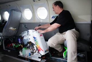
The shuttle imaging radar, as the instrument is called, includes the most massive piece of flight hardware ever built at JPL--a 23,100-pound antenna that measures nearly 40 by 13 feet. It will collect data from 400 sites scattered around the planet.
The study of the movement of sand and dust across the Earth is just one of several parts of the project, and it can only be done with a space-borne radar camera, Evans said. That is the one technology capable of making precise measurements of the texture of the ground on a global scale.
As the shuttle orbits the Earth, instruments on 50-foot-tall towers at the various sites will measure the direction and velocity of the wind at different heights. The radar camera aboard the shuttle will give scientists the third component they need to understand the movement of the sand--the precise surface texture of the ground.
“Our experiment is to use radar to characterize the surface roughness,” said Ronald Greeley, professor of geology at Arizona State University and leader of an international team of scientists that will carry out the sand experiment. The technology could someday enable scientists to map nearly the entire Earth from orbit and determine which areas are most susceptible to severe sand and dust storms, and how damaging the storms might be.
The radar camera will bounce its signals off the ground, and the strength of the echo should reveal just how rough the surface is. A rough surface will scatter more of the beam and thus reflect a weaker signal back to the shuttle.
What the scientists are after is the “aerodynamic roughness” of the surface, not just its texture, Greeley said. Some surfaces may look smooth to the human eye, he added, but they may behave aerodynamically as though they were very rough. And it is the aerodynamic behavior that determines sand transport.
“If you look at a lake bed in the desert, sand can move across that surface pretty easily (because it is smooth),” he said. “On the other hand, if you went out to a very rough surface, sand is going to get trapped, it’s not going to move very easily.”
Greeley believes that the shuttle’s radar system will help his team determine which surface texture is aerodynamically smooth or rough, and thus which areas are most vulnerable to fierce dust and sand storms.
Ultimately, the program could help scientists match the success achieved by U.S. Department of Agriculture officials decades ago. Researchers determined more than 50 years ago that the fierce storms of the Dust Bowl era were caused in part by agricultural procedures that left valuable topsoil vulnerable to wind transport. The wind picked up the soil and blew it away, robbing farmers of the rich dirt needed for crops and creating havoc for people who were blinded by blowing dust.
Once the process was understood, farmers changed their procedures--including when they plowed the land--and the era of the Dust Bowl came to an end.
“Today, we don’t have the kind of dust storms we had then,” Greeley said.
The radar camera could become a valuable tool in predicting sand storms and preventing them.
Evans said another valuable application of the radar technology is in the measurement of water content in clouds and snow because radar waves are sensitive to moisture.
“We may be able to measure the wetness of the snowpack from space,” she said.
Such a technique would provide a far more comprehensive and reliable estimate of the amount of water in the Sierra snowpack each season, and thus permit a more exact estimate of the amount of runoff that could be expected. Now, that estimate is based on winter measurements done on the ground at a few sites that may--or may not--be typical of the overall snowpack.
The experiment will also study vegetation around the world, and it is particularly useful for that because the radar waves will penetrate beneath treetops and tell scientists what is growing on the ground below.
The radar project will be the primary experiment aboard the Endeavour, which is scheduled to blast off from the Kennedy Space Center in Florida on April 7. It is to be flown a second time in August and data from the two flights will help NASA administrators decide whether they want to put the instrument aboard a satellite and leave it permanently in space where it can study the Earth on a continuing basis.
Because the 52 scientists from 13 countries involved in the project want to see as much of the Earth as possible, the Endeavour will be launched on a trajectory that will cover most of the globe. The shuttle’s orbit will range from 57 degrees north of the Equator to 57 degrees south, allowing it to survey everything from northern Canada to South Africa.


