Into the Canyons of South Fork
- Share via
For geographical orientation, Southland hikers often divide the San Gabriel Mountains into front country, back country, foothills, high country, east end, west end, urban interface and alpine wilderness. The north (desert) side rarely comes up for discussion.
The San Gabriels thrust abruptly up from the desert floor, stopping much of the Mojave’s heat and hot air from reaching the Los Angeles Basin. From vista points near the crest of Angeles Crest Highway (California 2) at Dawson Saddle (7,901 feet), travelers get grand panoramas of the Mojave Desert, which, from this vantage point, seems close to the metropolis. Clear-day vistas are quintessential west Mojave: dry lake beds and isolated buttes.
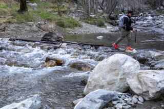
The desert side of the San Gabriels is characterized by deep V-shaped gorges. Perhaps the most dramatic of these is the South Fork of Big Rock Creek, a steep canyon that extends from the northern crest of the range down to the San Andreas Fault Zone and the intensively fractured Devils Punchbowl.
South Fork Trail climbs from the high desert to the highway, from pinyon pine to ponderosa pine. Vegetation changes with elevation--from sage and cactus to manzanita, incense cedar and spruce. The path traces the South Fork of Big Rock Creek Canyon adjacent to Devils Punchbowl and ascends to Islip Saddle (6,685 feet) on Angeles Crest Highway.
Directions to trail head: From California Highway 14 (Antelope Valley Freeway) south of Palmdale, take the Pearblossom Highway exit and drive five miles east to California Highway 138. Continue 8.5 miles more east on 138 to Longview Road. Turn south (signed for Devils Punchbowl County Park) and travel 2.2 miles to Fort Tejon Road. Signs point to the Devils Punchbowl, but follow the signs left toward Valyermo. Join Valyermo Road for 3.5 miles to signed Big Rock Creek Road. Turn right and travel three miles to the signed turnoff for South Fork Campground and proceed one mile on the dirt road to the special day use/hikers’ parking lot below the campground. The signed trail departs from the parking area.
Hikers wishing to make a one-way descent on South Fork Trail will find the upper trail head at Islip Saddle parking area, located at mile 64.1 on Angeles Crest Highway.
The hike: From the parking area below South Fork Campground, join the signed trail heading south. Almost immediately, you’ll reach a trail junction with the path leading to Devils Punchbowl. Stay left and pass South Fork Campground.
After 0.25 mile, cross to the other side of Big Rock Creek and switchback up the canyon wall. The trail continues its ascent, sometimes at quite a height above Big Rock Creek. With your ascent the environment changes from desert to forest, though not immediately, and you can note some intriguing combinations of desert and woodland plant life.
South Fork Trail meets Angeles Crest Highway where the Pacific Crest Trail climbs northward toward Mt. Williamson.
John McKinney is the author of “Day Hiker’s Guide to California’s State Parks” (Olympus Press, $14.95).
(BEGIN TEXT OF INFOBOX / INFOGRAPHIC)
South Fork Trail
WHERE: Big Rock Creek Canyon
DISTANCE: From South Fork Campground to Islip Saddle is 1o.4 miles round trip with 2,100-feet elevation gain.
TERRAIN: Desert side of the San Gabriels.
HIGHLIGHTS: Desert views from pinyon pine-cloaked slopes.
DEGREE OF DIFFICULTY: Moderately strenuous.
FOR MORE INFORMATION: Angeles National Forest; tel. (626) 574-5200.
More to Read
Sign up for The Wild
We’ll help you find the best places to hike, bike and run, as well as the perfect silent spots for meditation and yoga.
You may occasionally receive promotional content from the Los Angeles Times.


