Dry conditions in California continue to expand, but will March rains dent the drought?

- Share via
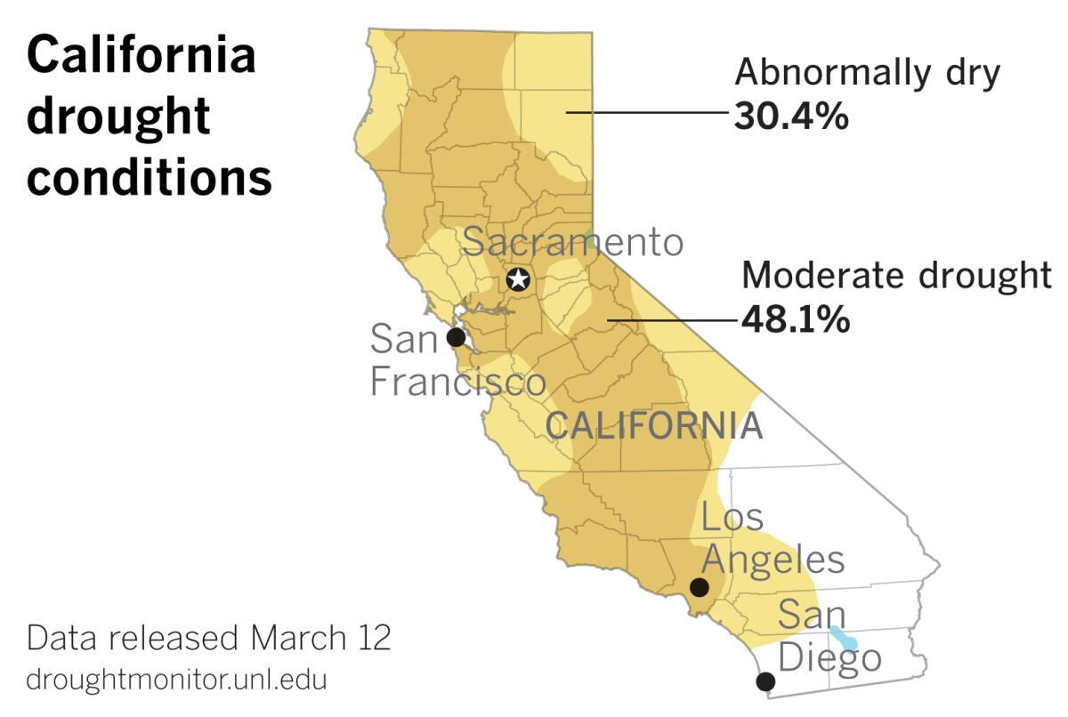
The most recent U.S. Drought Monitor data, released Thursday, show that about 48% of California is in moderate drought. That’s up from 34% a week ago.
An additional 30% of the state is abnormally dry, according to the data.
The data were compiled Tuesday, so the figures do not reflect moisture from Southern California’s most recent storm. Northern California, which is generally farther behind seasonal precipitation norms, received little benefit from that storm, which primarily dampened the southern and central parts of the state.
The Drought Monitor map issued Thursday shows that portions of several Central and Southern California counties that were abnormally dry a week ago have now slipped into drought. Most of San Luis Obispo, Santa Barbara, Ventura and Los Angeles counties have joined the majority of Kern County in the moderate-drought category. The abnormally dry designation has spread south and east to cover Orange and western portions of San Bernardino and Riverside counties. The northwestern corner of San Diego County, where Camp Pendleton is located, is also abnormally dry.
In the northern part of the state, areas of moderate drought in Humboldt, Trinity and Shasta counties have expanded and merged with a band of drought territory along the Oregon border in Siskiyou County. This creates an almost continuous band of moderate drought stretching from Long Beach to the Oregon line.
Although the reservoirs are in good shape from previous wet years, drought in the mountains of Northern California bodes ill for agricultural and municipal water users in Southern California and the San Joaquin Valley. The winter snowpack in the Northern Sierra feeds California’s major reservoirs, which provide water for large parts of the state.
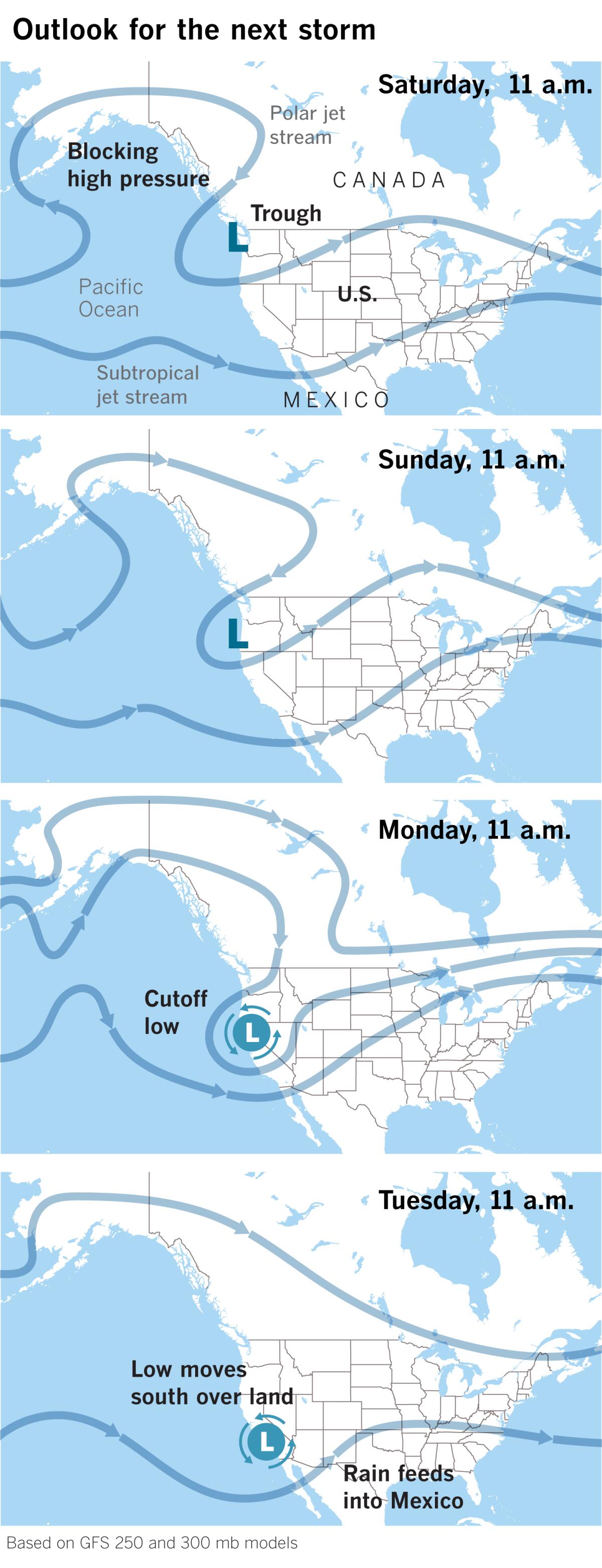
The National Weather Service in Monterey predicts that the storm door will open again this weekend and remain open through next week. As a high-pressure ridge pushes into Alaska, an upper low will move south along the West Coast. The system will move slowly but will be showery in nature, so rainfall amounts are not expected to be impressive. Rain is forecast to start in the North Bay Area as early as Saturday morning and spread southward through the day.
The system is expected to be cold, since it is hooking into air from northern Canada, but the colder air will not arrive until Sunday and Monday. Snow is possible over the higher peaks.

How much help will the system provide for the snowpack? “The uncertainty in terms of moisture is about whether the low comes down over land or water,” said Bill Patzert, former climatologist with NASA’s Jet Propulsion Laboratory. It will be moisture-starved if it comes south mostly over land — “If it comes sliding southward down the spine of the Sierra,” in Patzert’s words, as some of the disappointingly dry “inside slider” systems have done this season.
Lisa Phillips, a meteorologist with the National Weather Service in Oxnard, sees the low-pressure system staying close to the coast but picking up some moisture, although lacking the subtropical moisture associated with this week’s system.
Regardless, the system will bring much colder air and gusty northwest winds. Timing the arrival of precipitation in Southern California is tricky — it could start Monday afternoon or evening, spreading from north to south.
Because of the storm’s northern origin, snow levels will be much lower than with this week’s storm, and snow is expected to affect Interstate 5 over the Grapevine. Snow levels will start out above 5,000 feet but drop to 3,000 feet or lower by Tuesday morning, according to the National Weather Service. Blowing snow, icy conditions and reduced visibility could make travel at higher elevations hazardous.
Precipitation could last through Wednesday afternoon and possibly beyond.
As with this week’s storm, the majority of subtropical moisture will stay to the south. The subtropical jet stream is active this winter as it is every winter, according to Eric Boldt of the National Weather Service in Oxnard, but this year it has been plowing into Mexico, well south of California. Moisture has been carried across Mexico and into the the U.S. Southeast, resulting in severe weather and flooding.
March’s storms have at least been more promising than those of January or February. “Welcome, but not drought busters,” concluded Patzert.
More to Read
Sign up for Essential California
The most important California stories and recommendations in your inbox every morning.
You may occasionally receive promotional content from the Los Angeles Times.


