As rain pelts soggy Southern California, residents are urged to stay vigilant for mudslides


- Share via
A slow-moving winter storm that pelted Los Angeles with steady rain Monday was expected to subside briefly Tuesday before roaring back at nightfall with heavy downpours, strong winds and the possibility of thunder and lightning.
Authorities, fearing the effect of additional rain on hillsides and creek beds already saturated by a massive storm earlier this month, issued flash flood warnings for a swath of L.A. from Malibu to Griffith Park as well as portions of the San Fernando Valley.
Residents were encouraged to remain in their homes and stay vigilant for signs of mudslides.
There were scattered reports of mudslides throughout the day, including on Pacific Coast Highway near Santa Monica; the U.S. 101 near La Conchita in Ventura County; and north of Malibu, where large boulders were said to block lanes at the intersection of Malibu Canyon and Piuma roads north of Malibu.
An evacuation warning was issued due to possible mud and debris flows along Santa Maria Road north of Topanga Canyon Boulevard through 9 a.m. Wednesday.
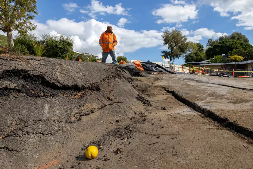
Damage in the city of L.A. as of Monday evening appeared mostly limited to flooded freeway ramps, a few power outages and a couple dozen downed trees.
In the Sepulveda Basin, Burbank Boulevard between Balboa Street and the 405 Freeway and Woodley Avenue from Victory to Burbank boulevards were closed because of flooding, according to the L.A. City Emergency Management Department. Along the northbound 405, the offramp for Skirball Center Drive and Mulholland Drive remains closed due to a sinkhole last week.
In Santa Barbara, where some places in the Santa Ynez mountains recorded nearly 10 inches of rain by noon, flooding on the tarmac forced the closure of the airport, and a woman’s body was found near a swollen creek.
It was unclear whether the death in a downtown Santa Barbara section of Mission Creek was related to the storm. Sgt. Ethan Ragsdale said in a statement that the body was “entangled in the trees off the bank of the creek.” Detectives have not identified the woman but do not believe that she was a victim of foul play, according to the statement.
The storm, which began Sunday, is forecast to bring 2 to 5 inches of rain to L.A. — and as much as 5 to 8 inches along the foothills and in the Santa Monica and San Gabriel mountains — before moving out of the area Wednesday. Richard Thompson, a meteorologist at the National Weather Service in Oxnard, said the “second impulse” or phase of the weather system will began rolling in from the ocean late Tuesday and bring more intense and unpredictable conditions.
“The atmosphere is really unstable,” he said. Up to an inch of rain could fall in an hour, with a 20% chance of thunderstorms and risk of water spouts, dangerous wind gusts and even tornadoes.
“That’s a very low probability, but the potential is there,” he said.

Based on their expertise, forecasters at the National Weather Service in Oxnard correctly anticipated that even the machine-calculated, eye-popping rain totals were probably an underprediction.
Rainfall through Monday evening varied widely.
Long Beach recorded just under half an inch by Monday evening, while Pasadena had 1.54 inches, Beverly Hills 2.19, downtown 1.05 and Porter Ranch 2.95. To the north, Ventura saw 3.39 inches, Lompoc 3.44 and the Alisal Reservoir near Solvang 6.11.
Many areas are still recovering from the four-day early February atmospheric river that inundated much of the state and dropped up to 14 inches of rain on L.A. alone.
In Rancho Palos Verdes, residents in neighborhoods vulnerable to landslides were bracing for the possibility of the saturated ground shifting underneath their houses as more rain fell.
The landmark Wayfarers Chapel closed indefinitely last week due to increasing land movement, disrupting the plans of couples who had planned to get married there.
L.A. County Supervisor Janice Hahn urged Gov. Gavin Newsom to visit the area and see the damage, noting that Rancho Palos Verdes officials planned to ask him to declare a state of emergency.
“I think if the Governor came here and saw the buckling streets, the homes sinking and cracking apart, and the historic Wayfarers Chapel on the verge of collapsing, he would understand the urgency of this request,” she wrote in a news release.
More and faster land movement has wreaked havoc across Portuguese Bend on the Palos Verdes Peninsula, where a slow-moving landslide has lurked for decades.
Further south, residents are still reeling from the historic rainfall and dramatic flash floods that submerged much of San Diego in January. Late Monday, President Biden issued a major disaster declaration and made federal funding available for those seeking temporary housing, home repairs and other recovery needs. (Residents and business owners who sustained losses in San Diego County can begin applying for assistance at www.DisasterAssistance.gov.)
Brian Ferguson, deputy director of the state Office of Emergency Services, said Monday of this latest storm that people should keep their guards up, even if the rainfall seems comparatively minor.
“It’s a different type of storm than we had before, but it is definitely still potentially deadly,” he said, adding that the waterlogged ground means that hillsides are primed to give way.
“There’s so much saturation that there could be a risk of debris flows and landslides for several weeks after the rain stops,” he said. A particular concern, he said, is high wind. Gusts as strong as 60 miles per hour were recorded Monday, raising the risk of toppled trees or snapped-off branches.
“The No. 1 killer in the last storm was trees and tree limbs falling on people,” he said.
In Santa Barbara, officials used cranes to remove debris from the flooded runways, and it was unclear when planes could resume operations.
“The airport is surrounded by creeks and waterways, and those are overflowing,” said Jackie Ruiz, public information officer for the county Office of Emergency Management.
The highest precipitation in the state was recorded in the San Marcos Pass in the mountains north of Santa Barbara, where 10.86 inches of rain fell by Monday evening. Yet business remained steady at the historic Cold Spring Tavern.
“We had almost an hour wait for lunch,” said Bianca Anderson, the assistant manager, adding that crowds that normally spill out on the former stagecoach stop instead packed into the bar. “We had the fireplace going, and it was cozy.”
Times staff writers Rong-Gong Lin II and Anthony De Leon contributed to this report.


Sign up for Essential California
The most important California stories and recommendations in your inbox every morning.
You may occasionally receive promotional content from the Los Angeles Times.
More From the Los Angeles Times


Podcasts

Many Altadena & Pacific Palisades residents can’t afford to rebuild. What will this displacement mean for their communities?

In 2016, Sherri Papini from Redding faked her kidnapping, a hoax uncovered three weeks later. This week’s podcast revisits why the “happy housewife” plotted it and why the decade-old story is back.

Trump’s new budget guts federal solar/wind aid, favoring fossil fuels. Sammy Roth talks with Jesse Jenkins about its potential to worsen climate pollution & raise energy costs.


