A San Andreas fault mystery: The ‘slow-moving disaster’ in an area where the Big One is feared

A San Andreas fault mystery: The ‘slow-moving disaster’ in area where the Big One is feared
- Share via
The San Andreas fault begins its dangerous dance through California at the Salton Sea, at a spot that seismologists long have feared could be the epicenter of a massive earthquake.
But in recent months, this desolate location where the North American and Pacific plates rub together has become the focus of intense interest for a type of movement that is less the Big One than the Slow One.
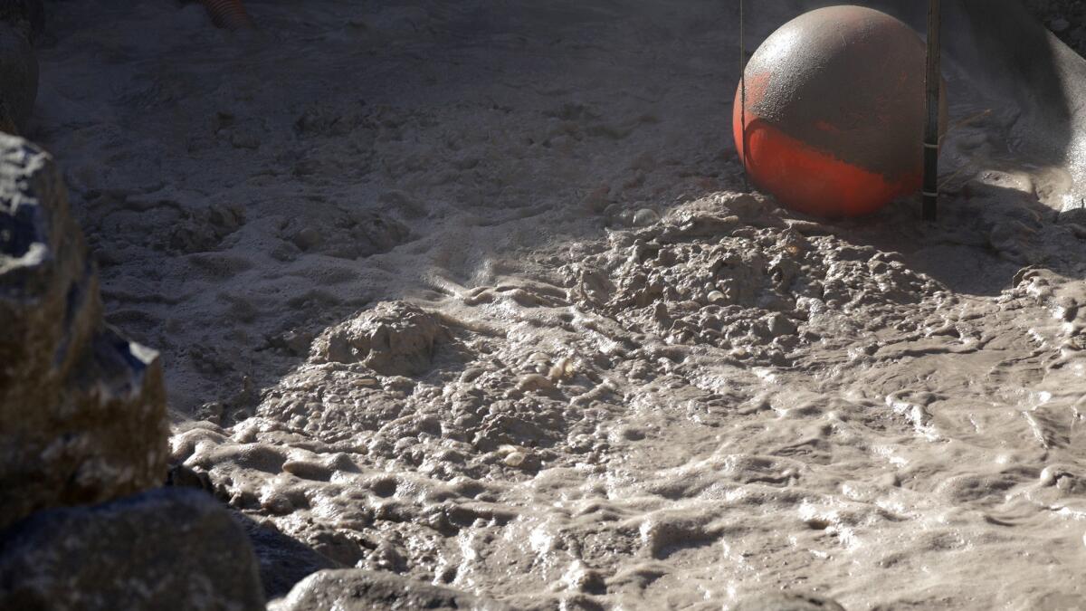
A muddy spring mysteriously has begun to move at a faster pace through dry earth — first 60 feet over a few months, and then 60 feet in a single day, according to Imperial County officials.
There’s no evidence suggesting this is an immediate precursor to a large earthquake, said U.S. Geological Survey geophysicist Ken Hudnut, who visited the moving spring in July. In fact, the area has been seismically quiet in recent months, with relatively few earthquakes.
Hudnut and other experts stress the movement is not seismic activity. But it’s occurring partly as a result of historic earthquake activity that caused cracks, allowing gases produced deep underground to reach the earth’s surface.
The biggest worry is that the slow-moving scientific mystery could become destructive in other ways.
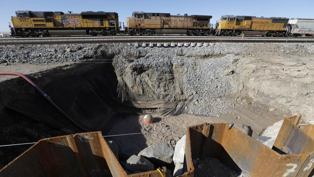
In its path are Union Pacific freight railroad tracks that connect the Inland Empire to Yuma, Ariz.; a petroleum pipeline owned by Kinder Morgan, one of North America’s largest energy companies; a stretch of fiber optic telecommunications lines owned by Verizon; and a portion of Highway 111, a major roadway connecting Interstate 10 in the Coachella Valley to the California-Mexico border.
“It’s a slow-moving disaster,” said Alfredo Estrada, Imperial County’s fire chief and emergency services coordinator.

Imperial County declared an emergency this summer, enabling officials to expedite efforts to prevent damage and perhaps even to stop the movement of the spring from getting closer to the railroad tracks.
So far, they haven’t worked.
Officials have been trying to drain water from the moving spring. Union Pacific built a 100-foot long wall of large boulders and steel more than 75 feet deep in the earth in an effort to protect the railroad.
But in October, the muddy spring sneaked underneath the wall, moving it ever closer to railroad tracks.
Overall, the pit, which produces a faint odor of rotten eggs, has moved more than 240 feet from where it was documented as being a decade ago. Based on publicly available satellite images, the spring hadn’t appeared to move much until roughly 2015, Hudnut said, but movement became particularly noticeable earlier this year.
Union Pacific has been forced to build temporary tracks to avoid running trains over land impacted by the spring. Trains are now moving more slowly through the area, according to the company.
The railroad may need to consider more permanent solutions, including building a bridge to bypass potentially unstable land, a company spokesman said.

Caltrans is also prepared to shut down a portion of Highway 111 if the mud spring approaches the roadway, and has already planned a set of detours, said agency spokesman Ed Joyce.
Indeed, the movement of the spring, even at its fastest, is far slower than the speed of a common snail.
The spring has been traveling much like a moving sinkhole, with carbon dioxide bubbling up from a pool in a ditch, with the mud about 30 feet and 40 feet below the desert surface, Hudnut said.
As the spring moves through a soft sedimentary rock called mudstone, it leaves behind a sunken, sodden trail below the desert surface, Hudnut said.
Geologically, how mud springs form is somewhat similar to how sinkholes form — movement of liquid deep underground that undermines the earth’s surface, Hudnut said. A cavity forms underground, and expands upward until it breaks through to the surface, forming a circular pit that gets larger as it continues to erode from below.
Imperial County officials said the muddy spring of interest has been documented since the 1950s, and hadn’t moved for decades. Signs of movement were detected years ago, said David Lynch, a geophysicist who has been studying muddy springs for 12 years.
It was only in the last six months that it picked up enough speed that it began to pose a threat to man-made infrastructure, Imperial County officials said.
Muddy springs have been well known features of Imperial County’s Salton Trough for decades. They are not like Old Faithful at Yellowstone, a hot spring that involves water circulating underground that becomes superheated from molten rock.
The spring in question is actually only about 80 degrees Fahrenheit, Hudnut said. It’s bubbling not from boiling water, but carbon dioxide being created from deep underground the earth’s surface.
The carbon dioxide is probably being formed as a result of the geologic processes deep underneath this part of California. As thousands of years of loose sediment dumped by the Colorado River get pushed deeper underground, where there’s more pressure and heat, the material is getting cooked and transformed into sandstone or greenschist rock, which produces carbon dioxide, Hudnut said.
That carbon dioxide is likely coming out of the ground where there are fractures in the earth, Hudnut said.
More than a decade ago, Lynch and Hudnut published a study in the Bulletin of the Seismological Society of America documenting a number of muddy springs and similar geological phenomena. When mapped, the geothermal features formed a line that appeared to be a continuation of the San Andreas southeast of the conventionally accepted terminus of the fault. They wrote that the geothermal features “may represent a surface manifestation of the San Andreas fault southeast of the Salton Sea.”
The movement of muddy springs is not unheard of.
Max Rudolph, an assistant professor at UC Davis who studies geothermal activity in the Salton Trough, said similar features in other areas have moved, but it has taken decades or longer for there to be noticeable movement.
“We know [that in the 19th century] before the Salton Sea was present in the Salton Trough, early travelers described a treacherous environment with bubbling mud pots and springs that made travel across the trough nearly impossible,” he said, indicating that geothermal activity in that area has dramatically changed over hundreds of years.
The Salton Sea was formed accidentally in 1905 when the Colorado River breached its banks.
Onlookers would be wise to stay away from the spring. If people were to fall in, the toxic air and lack of oxygen would suffocate them in minutes, Lynch said. But the carbon dioxide thins out within a few feet of the hole.
The nearest community to the muddy spring is Niland, about five miles away.
Lynch said he expects the mud spring will continue moving. But its slow place should give agencies and companies plenty of time to prepare.
“It’s a quirky thing,” said Lynch, who has been consulting with Union Pacific since May. “If there was no railroad nearby, you wouldn’t even know about it. This would just be something out there chewing out the desert.”
alejandra.reyesvelarde@latimes.com
Twitter: @r_valejandra
More to Read
Sign up for Essential California
The most important California stories and recommendations in your inbox every morning.
You may occasionally receive promotional content from the Los Angeles Times.


