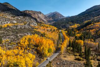
Eastern Sierra: A backpack to Pioneer Basin
- Share via
Backpackers in the Eastern Sierra got a late start this summer, thanks to last winter’s huge snowpack. Early-season hikers encountered snow-covered mountain passes and dicey-to-impossible creek crossings. Forest officials are still urging caution when crossing backcountry streams, which are running higher than normal. But the snow runoff is past its peak, leaving the upper elevations mostly snow-free and teeming with wildflowers and hungry trout —along with mosquitoes.
A late August backpack in the John Muir Wilderness to spectacular Pioneer Basin took us up and over 12,000-foot Mono Pass, from the appropriately named Mosquito Flat trailhead near Rock Creek , an 1,800-foot elevation gain. The trail at first rises above the glaciated Little Lakes Valley, with its stunning views of towering peaks. We peeled off to the Mono Pass trail, and 3.5 miles later, encountered the partly snowed-in pass. With a full backpack it was tricky footing across the snowfield, but we followed others’ footsteps and were glad for hiking poles. (Tip: On the return trip, we noticed a dirt footpath above the snow that we missed on the way in).
We camped a few miles past the pass, at Upper Trail Lake, a breezy spot just below 11,000 feet, and blessedly mosquito-free. From there it was mostly downhill, with a mild crossing of ankle-deep Golden Creek before getting to the Mono Recesses area, a series of hanging valleys above Mono Creek. A word to the ankle-twisting-prone: This route is mega-popular with horse pack trips and the trail has suffered for it: sturdy hiking boots and poles are a must because the trail is rocky and gouged in many spots.
After several miles and a descent of about 600 feet (trying not to think about the slog we’d have back up on the way out, ouch!), we reached Pioneer Basin, a bowl with six lakes and stunning views. We stayed at the lowest lake for two nights and day-hiked on our layover day under bright-blues skies along streams and wildflower-filled meadows to several of the upper lakes. The fishing was rewarding, with small brook trout hitting nearly every fly we cast. Colorful golden trout prowl these high-elevation lakes, and a few trout I caught and released appeared to be rainbow/golden hybrids. The mosquitoes were fierce where we camped; head nets were a must, particularly at sunset. The blood-suckers were scarcer higher up in the basin.
Despite the popularity of this part of the John Muir Wilderness, we had Pioneer Basin to ourselves on this Sunday through Wednesday trip — nobody camped at the lakes as far as we could tell. We came across only a few day-hikers from a pack trip, which was base-camped near where Third Recess meets Mono Creek, several miles away. Horse pack “spot trips” are very popular in the Mono Recesses area, with visitors riding in with food and supplies and being picked up days later, or “dunnage” trips, where a load is ridden in and visitors hike in carrying only day packs. The trail continues along Mono Creek, eventually joining up with the John Muir Trail near Quail Meadows and Lake Thomas Edison.
Our last morning started with a bang — an earthquake that we heard before we felt, jolted us in our sleeping bags. We heard a distant rockfall about 30 minutes later — unsettling events, considering we had an eight-mile hike along steep, rocky paths on our way back to the trailhead. Luckily we had a clear path on the way out.
There’s not much you can do if a quake hits in the backcountry, but here are some tips for trekking this wilderness gem: acclimate for at least one night before heading out. We stayed at Mammoth Lakes for several nights and were still feeling the altitude in the first days of our backpack. Also, bear canisters are a must; we didn’t see any sign of ursine, but all food and toiletries should be safely stashed in a bear-proof container. And don’t plan on any roaring campfires — they’re forbidden at this tree-scarce elevation above 10,000 feet.
Conditions should be optimal in the High Sierra through September, or until the snow starts to fly. A day hike we took last October in Little Lakes Valley was a treat thanks to early-season snowfall...the same snow we encountered nearly a year later.
For more information, contact the Inyo National Forest in Bishop at (760) 873-2400. Wilderness permits are required and cost $5 per person. We ordered ours ahead of time (760) 873-2483 and picked them up at the Mammoth Ranger Station in Mammoth Lakes (760) 924-5500.
More to Read
Sign up for The Wild
We’ll help you find the best places to hike, bike and run, as well as the perfect silent spots for meditation and yoga.
You may occasionally receive promotional content from the Los Angeles Times.


