Talk About Mapping a Detailed Business Plan: Their Plan is More Maps
- Share via
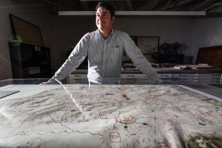
Michael Beard had been assessing the market potential for his new line of decorator wall maps by tacking them to bulletin boards in student unions, computer centers and geography departments from Cal Poly Pomona to the University of Washington in Seattle.
He was encouraged to find that most were stolen the same day he put them up.
But Beard saw even broader potential when a United Parcel Service delivery man paused at the map on Beard’s office wall back in Medford, Ore.
“He started talking about places where he’d gone hunting, fishing and rafting,” Beard recalls. “He could really see where he had been. And my partner and I began to realize that we hadn’t counted on that response to our maps from ordinary people who are more used to paying $3 in a vending machine for a road map.”
That was four years ago.
Today, Raven Maps & Images, a tiny company founded by two expatriate Californians, has caught the wave of public interest in all things environmental.
Sales of Raven’s striking, highly detailed, yet inexpensive maps have jumped 40% to 50% a year since 1986, guided by just such seat-of-the-pants consumer research. Most comes through a toll-free number and direct-mail marketing using mailing lists rented from the Sierra Club, Greenpeace, the Wilderness Society and other environmental organizations.
Beard reports that every year since 1986, Raven has doubled the number of catalogues it has sent out. They will mail as many as 500,000 copies in two weeks and expect to mail 1 million in their 1991 season.
Beard projects sales for the seven-employee company to top $700,000 in 1990, though this could increase dramatically depending upon the success of a long labor of love, an other-worldly three-view portrait of the globe that the firm will begin to market later this month.
Though Beard and Stuart Allan, his partner and the firm’s cartographer, haven’t pitched retailers, about 100 map and travel-equipment stores nationwide have seen their maps and arranged to sell them--including Pasadena Map Co. in Pasadena and ALS (for Air, Land and Sea) Maps in West Covina.
“They have beautiful coloration, and they’re darned accurate,” says Jack Sera, an owner of ALS Maps. Sera reports that they sell especially well whenever he has the room to give them adequate display.
“Their maps are very detailed,” says Carolyn S. Hickey, manager of Pasadena Map Co. “But it’s a real easy map to find things on, and a map you would enjoy looking at, because it’s not real busy.”
That was the map maker’s intent, at least with the company’s most popular series, the individual state maps.
“The main difference from other state maps,” says Allan, “is that at a glance you see elevation and land form. If you look at a contour map, you have to figure it out.”
“People call me up all the time and tell me that with the California wall map, it’s the first time they ever understand what the Central Valley is, “ says Beard.
In fact, the sense of depth on the state series is so immediate that many people take them to be three-dimensional relief maps.
Other Raven products, maps that have been digitized and transformed by computer, are favorites on the walls of computer scientists and geologists. One is a map of Mt. St. Helens that looks like a carefully crumpled handkerchief. Another, billed as Blue Whale’s Hawaii, is a striking view of the islands as a whale at sea level might see them--both above and below the surface.
Once the map information, often taken from U.S. Geological Survey maps, is entered into the computer, the maps can be presented from various perspectives.
Such computer graphics are not unknown. But what attracts scientists and environmentalists to Raven’s versions are both their beauty and their accuracy.
“Many people are computer experts, but don’t know beans about geology,” says Russell Guy, vice president and co-founder of Geoscience Resources, Inc., a Burlington, N.C., scientific supply company. “Raven maps were produced by professional geologists.”
Geoscience buys maps from more than 100 foreign and 35 state governments, as well as from such commercial map makers as Raven.
“Very, very few map makers for the public market have done this,” says Guy. “It’s very expensive and difficult to do.”
Often in professional map making, expensive products are targeted at a small, exclusive clientele. But Beard and Stuart decided they didn’t want their work seen only in corporate boardrooms or similarly secluded circumstances. They decided to print on relatively inexpensive paper stock and to make their profit from volume.
Most of the state series are priced at $20, or $45 for a map laminated with a 1.5-mil vinyl coating on both sides. The larger world map will cost $35, or $60 in the laminated version.
“Volume is kind of a main thing here,” says Beard. “We could have produced these maps only on museum quality linen and charged a very fancy price for them. We decided to print them at the $45 laminated rate, so more people could have them.”
More to Read
Inside the business of entertainment
The Wide Shot brings you news, analysis and insights on everything from streaming wars to production — and what it all means for the future.
You may occasionally receive promotional content from the Los Angeles Times.


