March Going Out Much Like a Lion
- Share via
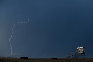
A large swirl of storm clouds hovered over San Diego County Monday, bringing surges of heavy rain and snow that played a role in scores of traffic accidents and prompted forecasters to issue flood, blizzard and tornado warnings.
Lifeguards spotted a waterspout over the sea 1.6 kilometers off Oceanside Harbor at 4:15 p.m., prompting the National Weather Service to issue a tornado warning for the northwestern part of the county. The warning lasted 45 minutes.
Another waterspout and two funnel clouds were spotted over the ocean at about 11:30 a.m. off Oceanside and Camp Pendleton, said Wilbur Shigehara, a forecaster for the National Weather Service.
More than half an inch of rain fell at Lindbergh Field by Monday afternoon, and a total of 1 to 2 inches is expected before the scattered, vigorous storm system leaves the area Wednesday, Shigehara said.
“We’ll get breathers now and then,” Shigehara said, “with at least two more periods of intense rain with possible thundershowers and hail.”
Rainwater ran high in gutters and collected in pools and on roadways Monday as intermittent showers prompted the weather service to issue warnings of urban flooding and mudslides.
The northbound Leucadia off-ramp of Interstate 5 was closed because of flooding, California Highway Patrol spokesman John Marinez said. CHP officers responded to 78 accidents, in which 22 drivers suffered minor injuries. Marinez added that storms after dry spells routinely bring in more than 100 accidents.
“There are a lot of people spinning out,” Marinez said. “There’s a lot of water pockets out on our roads, and people are traveling at unsafe speeds. They are driving over their heads.”
Rare blizzard conditions were forecast for mountain areas, with wind gusts of up to 40 m.p.h. and snow levels down to 1,500 feet, Shigehara said.
Roads were clear and chains were not required early Monday evening, but conditions could change rapidly, Marinez said.
The storm is expected to drop 1 to 2 feet of snow in the mountains, and 1 to 2 inches of rain at Lindbergh Field. This is already the ninth wettest March on record.
A drier weather pattern is expected to develop Thursday, keeping the area dry and warmer at least until early next week, Shigehara said. A storm off of Hawaii stands an outside chance of coming into the area by Sunday, but will likely stall over the ocean and dissipate, he said.
“But this doesn’t mean the wet pattern is over,” he said. “We’re not out of the woods yet.”
Shigehara pointed out that, although the season’s rainfall is 1.77 inches above normal, it will take several seasons of above-normal rainfall to end the drought.
“Some people joke that this is the wettest drought ever,” he added. “Just because you’re in a drought doesn’t mean you don’t get flooding.”
More rain than normal fell during three seasons in the past five years of drought. In the past 30 years, San Diego got an average 9.32 inches of rain per season. In the 1985-86 season, the first year of drought, 14.1 inches fell. In 1987-88, 13.18 inches fell. The lowest amount was 1988-89, which only got 5.65 inches of rain.
“What if we turn dry again?” he said. “We’ll be back in the drought again. The rains we’ve had will only be a memory,” Shigehara said.
More to Read
Sign up for Essential California
The most important California stories and recommendations in your inbox every morning.
You may occasionally receive promotional content from the Los Angeles Times.


