Spirited Seaside of Patrick’s Point
- Share via
Though Patrick’s Point State Park, lies in the heart of the redwoods, other trees--Sitka spruce, Douglas fir and red alder--predominate on the park’s rocky promontories. The park in Humboldt County takes its name from Patrick Beegan, who homesteaded this dramatic, densely forested headland in 1851.
For hundreds of years, the Yurok people spent their summers in the Abalone Point area of the headlands. The Yurok gathered shellfish and hunted sea lions. Game and a multitude of berries were plentiful in the surrounding forest.
The area now called Patrick’s Point also had some spiritual significance to the Yurok. They believed Sumig, spirit of the porpoises, retired to Patrick’s Point when humans began populating the world.
Rim Trail follows an old Yurok pathway over the park’s bluffs. Spur trails lead to rocky points that jut into the Pacific and offer commanding views of Trinidad Head to the south and Big Lagoon to the north.
Directions to trail head: Patrick’s Point State Park is 30 miles north of Eureka and five miles north of Trinidad. Exit Highway 101 on Patrick’s Point Drive and follow the road to the park. Once past the park entrance station, follow the signs to Palmer Point.
The hike: The trail plunges into a lush community of ferns, salmonberry and salal. The scolding krrrack-krrrack of the Steller jay is the only note of dissent heard along the trail.
Abalone Point is the first of a half-dozen spur trails that lead from Rim Trail to Rocky Point, Mussel Rocks, Patrick’s Point, Wedding Rock and Agate Beach. Take any or all of them. (These side trails can sometimes be confused with Rim Trail; generally speaking, the spurs are much more steep than Rim Trail, which contours along without much elevation change.)
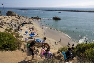
From Patrick’s Point and the other promontories, admire the precipitous cliffs and rock-walled inlets. Gaze offshore at the sea stacks, a line of offshore rocks battered by the surging sea. Seals and sea lions haul out on the rocks, which also double as rookeries for gulls, cormorants and pigeon guillemots.
Rim Trail meanders through a tapestry of trillium and moss rhododendron and azalea. Sword ferns point the way to a grove of red alder.
Rim Trail ends at the north loop of the Agate Beach Campground road.
Hikers wishing to explore Agate Beach should continue a short distance along the road to the signed trail head for Agate Beach Trail. This short, but very steep, trail switchbacks down to the beach.
In marked contrast to the park’s rocky shore that you observed from Rim Trail, Agate Beach is a wide swath of dark sand stretching north to the state parks at Big Lagoon.
Beachcombers prospect for agates in the gravel bars and right at the surf line. The agates found here are a nearly transparent variety of quartz, polished by sand and the restless sea. Jade, jasper and other semiprecious stones are sometimes found here. One more noteworthy sight is the huge quantity of sea-sculpted driftwood on this beach.
California’s North Coast / Rim Trail Where: Patrick’s Point State Park. Distance: From Palmer’s Point to Agate Beach Campground, 4 miles round trip. Terrain: Dramatic spruce and fir-forested headland perched above the Pacific. Highlights: One of the gems of the state park system; Agate Beach, famous for its agates and wave-sculpted driftwood. Degree of difficulty: Easy. Precautions: Avoid walking too close to the edge of the eroded, hazardous bluffs. For more information: Contact Patrick’s Point State Park, Trindad, Calif. 95570, (707) 677-3570.
More to Read
Sign up for The Wild
We’ll help you find the best places to hike, bike and run, as well as the perfect silent spots for meditation and yoga.
You may occasionally receive promotional content from the Los Angeles Times.


