By the Shores of Millerton Lake
- Share via
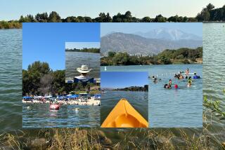
Millerton Lake, located in what is almost the exact geographic center of California, draws a lot of mainstream America to its shores: boaters, fishermen, water-skiers, campers, hikers. As many as three quarters of a million people each year come to this recreation area, 20 miles northeast of Fresno on the way to Yosemite National Park.
The park offers visitors a chance to pan for gold with its Gold Tours on Saturdays during November and March. On Saturdays in December, January and February, the park offers Eagle Tours: Visitors board boats and catch glimpses of wintering bald eagles, as well as dozens of other bird species.
Millerton Lake was created in 1944 when Friant Dam was built across the canyon of the San Joaquin River, which flows down from the High Sierra foothills into the Central Valley.
The lake inundated the historic town of Millerton. The town had evolved from an Army camp, Ft. Miller, into the Fresno County seat, complete with an impressive courthouse built in 1867.
Millerton Lake measures about a mile wide near the dam site, three miles at its widest. The lake backs up 16 miles into its river canyon.
Hikers heading for the hills surrounding the lake will find grassland, chaparral and oak woodland environments.
Best hike is South Shore Trail, sometimes called Winchell Ridge Trail, which follows the contours of the lake four miles from Blue Oak Picnic Area to the Marina at Winchell Bay. Because the first half of the trail closely parallels the road, most hikers will find the second half more satisfying; they begin at the South Bay Picnic Area.
Directions to trail head: From California 99 in Fresno, take California 41 north and proceed 20 miles to the California 145 turnoff. Follow the signs five miles east to the main park entrance on the south shore of Millerton Lake State Recreation Area. The park road follows the lake shore to the Blue Oak Picnic Area, where you’ll find trail head parking. Start your hike here or, better yet, continue another two miles to the South Bay Picnic Area.
The hike: From the picnic area, the trail turns east to McKenzie Point. It’s mellow walking with little elevation gain, as the path contours over oak-dotted grassy slopes.
The Upper Sonoran Life Zone is what botanists call the foothills around Millerton Lake. There are lots of oaks--blue, live and valley--plus the occasional digger pine and some chaparral.
You’ll get fine vistas of the lake, as well as over-the-shoulder views of the Millerton Courthouse. After skirting Winchell Bay, you’ll reach the marina, a no-nonsense facility that holds little interest for hikers.
Signs help walkers stay on the trail, which crosses Winchell Road just below another park entrance station, and continues along the lake shore before passage is forbidden due to private property rights.
More to Read
Sign up for The Wild
We’ll help you find the best places to hike, bike and run, as well as the perfect silent spots for meditation and yoga.
You may occasionally receive promotional content from the Los Angeles Times.


