Watered-Down Fun at Auburn
- Share via
The dam builders didn’t get their way on the American River.
In 1967, construction began on Auburn Dam, which would have turned the gorges and canyons near Sacramento into Auburn Lake. But the project was shelved after the collapse of a Montana dam, similar in design to Auburn, and conservation efforts by such groups as Friends of the River. The federal Bureau of Reclamation then allowed the state of California to use a portion of the river as a recreation area.
Though unlikely, the project could be revived: The dam was conceived in the 1940s and a few die-hard locals have been pushing for its construction ever since. As a result, no expensive roads or facilities have been constructed in the 30,000-acre Auburn State Recreation Area. Any such improvements would be covered by water if Auburn Lake came into existence.
Fishing, river-rafting, hiking and camping are popular activities at the park, about 25 miles east of Sacramento along more than 30 miles of the north and middle forks of the American River.
A favorite stretch of trail follows the American River from Ruck-a-Chucky Campground to the Ruck-a-Chucky Rapids. Early spring wildflowers--fairy lanterns, Indian paintbrush, lupine and many more--brighten the path.
Directions to trail head: From Interstate 80 on the outskirts of Auburn, exit on Auburn-Forest Hill Road and head east eight miles. Turn right on the dirt Drivers Flat Road (bumpy, but suitable for passenger cars with good ground clearance) and go 2 1/2 miles to Ruck-a-Chucky Campground and road’s end at the trail head.
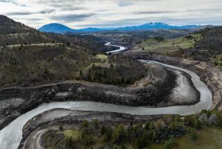
The hike: From the signed trail head, follow the closed road along the river. The American River, which has its headwaters in the deep snows of the Sierra Nevada, has deposited quite a collection of sand, rounded cobblestones and great boulders en route, and carved an impressive canyon as well.
If you look high above the riverbanks, you might see some little platforms marked by rock walls where Gold Rush-era miners lived.
Ruck-a-Chucky Rapids is not a stretch of river that wizened river-rafters run, so there is a portage trail that leads along the banks to get around the rapids.
Western Pioneer Trail
WHERE: Auburn State Recreation Area.
DISTANCE: From Ruck-a-Chucky Campground to rapids, 3 miles round trip.
TERRAIN: Banks of the American River, near Sacramento.
HIGHLIGHTS: Dramatic stretch of river.
DEGREE OF DIFFICULTY: Easy to moderate.
PRECAUTIONS: Drivers Flat Road may be closed after rainstorms due to muddy conditions.
FOR MORE INFORMATION: Contact the Auburn State Recreation Area, P.O. Box 3266, Auburn, Calif. 95604, (916) 885-4527.
More to Read
Sign up for The Wild
We’ll help you find the best places to hike, bike and run, as well as the perfect silent spots for meditation and yoga.
You may occasionally receive promotional content from the Los Angeles Times.


