The Shifting Global Picture
- Share via
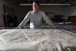
Bill Warren is one of those men who rarely asks for directions. “I’m a retired engineer,” he says. “Engineers have good spatial visualization.” It was his wife, Jane, an antiques dealer, who got him lost in the world of antique (pre-1900) maps in 1985, when she gave him a 1659 map depicting California as an island.
Warren’s interest soon grew into a serious collection of more than 100 maps, most of which date from the 1600s to the 1800s. He’s particularly interested in maps of northeast Asia and of California as an island. But he also appreciates his 1939 and 1999 maps of movie stars’ homes and a 1926 Atlantic City boardwalk map. “Maps are beautiful works of art. They’re fun and they’re an example of how man’s perception of his world changed with time.”
Map makers often improvised to cover what they didn’t know, he says. One of his maps from 1799 shows an ocean covering Oregon, Washington and parts of Canada. “If they had no clue what was there, they made it up,” says Warren, adding that most cartographers were just trying to make the best of the information they were given. “Maps were shorthand for explorers who kept notes, drawings and measurements so they could report what they’d seen.”
Inaccuracies endured for years because the copper plates that maps were printed from were expensive to replace. Thus, California wasn’t often shown as part of North America until the early 1700s.
Cartography has also reflected contemporary cultural prejudices: In a 1732 map in Warren’s collection, an “America” figure rises from a shell dispensing pearls and jewels onto Europe with one hand and guillotines and whips onto Native Americans with the other.
Warren, a past president of the California Map Society, now splits his time between his personal collection and more rarefied pursuits. He’s spent the last six months doing volunteer work on the Huntington Library’s map collection. Warren is about a quarter of the way through cataloging an archive of 1800 maps that founder Henry E. Huntington purchased in the 1920s. Among the surprises is a 1775 map depicting the British burning Cambridge after Bunker Hill. When Warren finishes, the library will have a computerized map catalog available to researchers. “A map is like a picture,” he says. “It can tell you in an instant so much information--it can take a book to literally figure it out. Maps are a terrific aid to describing history.”
More to Read
Sign up for The Wild
We’ll help you find the best places to hike, bike and run, as well as the perfect silent spots for meditation and yoga.
You may occasionally receive promotional content from the Los Angeles Times.


